

- Forecast
- Maps
- Live
- Weather State
- Spot Information


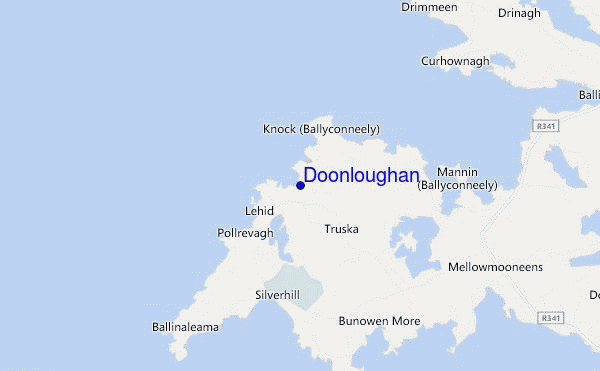
Doonloughan surf Forecast / Mayo and Achill Island / Ireland
- Map Icons:
 Break
Break Live Wave Height (m)
 Live Wind Speed (km/h)
 Surf Rating (10 Max)
 Ocean Swells (m)
- Wind Speed (km/h)
How big are the waves at Doonloughan today?
The current surf forecast for Doonloughan at 12PM is: 0.2m 6s primary swell from a North-northwest direction (forecast issued at 06:00am April 25). An open ocean swell of 0.5m 8s is not directed at the surf break, a second open ocean swell of 0.4m 14s is not directed at the surf break. The wind direction is predicted to be glassy.
| Time (IST) & Date | Wave Height | Wave Period |
|---|---|---|
| Morning (25 Apr) | 0.5ft (0.2m) | 7s |
| Afternoon (25 Apr) | 0.5ft (0.2m) | 8s |
| Evening (25 Apr) | 6.5ft (2.0m) | 9s |
Table - waves today at Doonloughan. (Swell directed towards the surf break)
Thursday 25 | Friday 26 | Saturday 27 | Sunday 28 | Monday 29 | Tuesday 30 | Wednesday 01 | Thursday 02 | |||||||||||||||||||||||||||||||||||||||||||||||||||||
| 4 AM | 7 AM | 10 AM | 1 PM | 4 PM | 7 PM | 10 PM | 1 AM | 4 AM | 7 AM | 10 AM | 1 PM | 4 PM | 7 PM | 10 PM | 1 AM | 4 AM | 7 AM | 10 AM | 1 PM | 4 PM | 7 PM | 10 PM | 1 AM | 4 AM | 7 AM | 10 AM | 1 PM | 4 PM | 7 PM | 10 PM | 1 AM | 4 AM | 7 AM | 10 AM | 1 PM | 4 PM | 7 PM | 10 PM | 1 AM | 4 AM | 7 AM | 10 AM | 1 PM | 4 PM | 7 PM | 10 PM | 1 AM | 4 AM | 7 AM | 10 AM | 1 PM | 4 PM | 7 PM | 10 PM | 1 AM | 4 AM | 7 AM | 10 AM | 1 PM | |
Rating (10 max) | ||||||||||||||||||||||||||||||||||||||||||||||||||||||||||||
Swell Height Map |    |    |    |    |    |    |    |    | ||||||||||||||||||||||||||||||||||||||||||||||||||||
| Wave Height (m) & direction (?) | ||||||||||||||||||||||||||||||||||||||||||||||||||||||||||||
| Period(s) (?) | 7 | 7 | 7 | 6 | 8 | 8 | 10 | 10 | 11 | 11 | 11 | 12 | 13 | 12 | 12 | 12 | 11 | 11 | 11 | 10 | 10 | 10 | 10 | 9 | 9 | 9 | 9 | 8 | 8 | 8 | 8 | 8 | 8 | 8 | 12 | 12 | 11 | 11 | 8 | 8 | 9 | 9 | 9 | 9 | 10 | 10 | 10 | 10 | 10 | 10 | 10 | 10 | 9 | 9 | 9 | 9 | 8 | 8 | 8 | 8 |
Wave (?)Graph | ||||||||||||||||||||||||||||||||||||||||||||||||||||||||||||
| Energy (?) | 12 | 4 | 4 | 4 | 7 | 391 | 911 | 1046 | 999 | 935 | 988 | 1100 | 1211 | 1020 | 761 | 650 | 438 | 345 | 286 | 216 | 209 | 173 | 166 | 121 | 116 | 82 | 80 | 73 | 76 | 89 | 155 | 145 | 116 | 21 | 100 | 98 | 125 | 85 | 246 | 228 | 177 | 150 | 123 | 99 | 143 | 128 | 128 | 86 | 233 | 242 | 234 | 188 | 141 | 108 | 82 | 58 | 54 | 51 | 32 | 30 |
Wind (km/h) | ||||||||||||||||||||||||||||||||||||||||||||||||||||||||||||
| Wind State (?) onshore cross-onshore cross-shore cross-offshore offshore glassy | on | on | glass | glass | cross- on | cross- on | cross | cross | cross | cross | cross | cross- on | cross- on | cross- on | cross | cross | cross | cross | cross | cross- on | cross- on | cross- on | cross- on | cross- on | cross- on | on | cross- on | cross | cross | cross- on | cross- on | cross | cross- off | cross- off | cross | cross | cross | cross | cross- off | cross- off | cross- off | off | off | off | cross | cross | cross | cross- off | cross | cross | cross | cross | cross | cross | glass | glass | glass | glass | glass | cross- on |
High Tide / height (m) | 7:05AM 3.54 | 7:20PM 3.65 | 7:37AM 3.46 | 7:51PM 3.59 | 8:11AM 3.33 | 8:25PM 3.47 | 8:50AM 3.16 | 9:05PM 3.31 | 9:36AM 2.96 | 9:53PM 3.14 | 10:37AM 2.78 | 10:57PM 3.00 | 11:57AM 2.67 | 12:16AM 2.95 | ||||||||||||||||||||||||||||||||||||||||||||||
Low Tide / height (m) | 1:04PM 0.43 | 1:25AM 0.45 | 1:34PM 0.54 | 1:57AM 0.53 | 2:06PM 0.69 | 2:33AM 0.67 | 2:41PM 0.86 | 3:15AM 0.83 | 3:24PM 1.06 | 4:09AM 0.99 | 4:21PM 1.26 | 5:24AM 1.08 | 5:44PM 1.40 | 6:57AM 1.01 | ||||||||||||||||||||||||||||||||||||||||||||||
Thursday 25 | Friday 26 | Saturday 27 | Sunday 28 | Monday 29 | Tuesday 30 | Wednesday 01 | Thursday 02 | |||||||||||||||||||||||||||||||||||||||||||||||||||||
| Sunrise | - | 6:16 | - | - | - | - | - | - | - | 6:15 | - | - | - | - | - | - | - | 6:13 | - | - | - | - | - | - | - | 6:11 | - | - | - | - | - | - | - | 6:09 | - | - | - | - | - | - | - | 6:07 | - | - | - | - | - | - | - | 6:05 | - | - | - | - | - | - | - | 6:03 | - | - |
| Sunset | - | - | - | - | - | 9:00 | - | - | - | - | - | - | - | 9:01 | - | - | - | - | - | - | - | 9:02 | - | - | - | - | - | - | - | 9:05 | - | - | - | - | - | - | - | 9:07 | - | - | - | - | - | - | - | 9:08 | - | - | - | - | - | - | - | 9:10 | - | - | - | - | - | - |
Rain (mm) | - | - | - | - | 1 | - | - | - | - | - | - | - | - | - | - | - | - | - | - | - | - | - | - | - | - | - | - | - | - | - | 1 | 1 | 1 | 1 | 1 | - | - | - | 1 | 1 | 1 | 1 | 1 | - | 1 | - | - | - | - | - | - | - | - | - | - | - | - | - | - | - |
| Temp. °C | 9 | 9 | 9 | 9 | 9 | 10 | 8 | 7 | 7 | 7 | 8 | 9 | 9 | 9 | 8 | 7 | 7 | 7 | 8 | 8 | 9 | 9 | 9 | 8 | 8 | 8 | 9 | 9 | 10 | 10 | 10 | 10 | 10 | 10 | 10 | 10 | 10 | 10 | 9 | 9 | 9 | 8 | 9 | 10 | 10 | 11 | 10 | 9 | 9 | 9 | 11 | 14 | 13 | 13 | 12 | 12 | 11 | 10 | 10 | 11 |
| Feels °C (?) | 6 | 6 | 8 | 7 | 6 | 6 | 1 | 0 | 0 | 1 | 2 | 3 | 1 | 0 | 1 | 1 | 2 | 3 | 4 | 3 | 3 | 2 | 3 | 4 | 4 | 5 | 6 | 5 | 5 | 6 | 7 | 7 | 6 | 7 | 5 | 5 | 3 | 4 | 4 | 3 | 3 | 4 | 5 | 7 | 7 | 6 | 6 | 5 | 5 | 4 | 6 | 8 | 9 | 9 | 10 | 11 | 10 | 9 | 9 | 10 |
FREE! Surf-Forecast.com widget for your website
The surf report / weather widget below is available to embed on third party websites free of charge and provides a summary of our Doonloughan surf forecast. Simply grab the html code snippet that we provide and paste it into your own site. You can choose your preferred language and metric/imperial units for the surf forecast feed to suit users of your site. Click here to get the code.


 Nearest