

- Forecast
- Maps
- Live
- Weather State
- Spot Information
Dunes Surf Forecast
/ Baja Norte (67 surf breaks) /
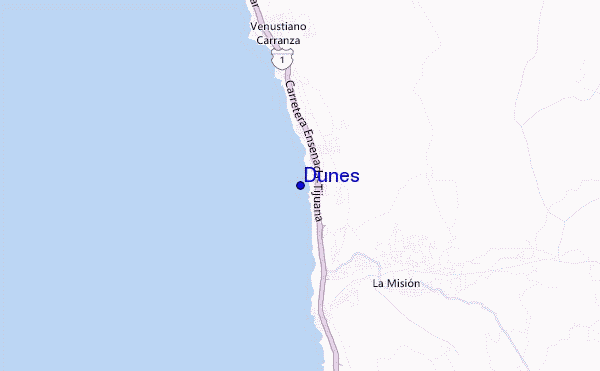
Dunes surf Forecast / Baja Norte / Mexico
- Map Icons:
 Break
Break Live Wave Height (m)
 Live Wind Speed (km/h)
 Surf Rating (10 Max)
 Ocean Swells (m)
- Wind Speed (km/h)
How big are the waves at Dunes today?
The current surf forecast for Dunes at 11PM is: 0.9m 14s primary swell from a South-southwest direction and 0.5m 18s secondary swell from a Southwest direction, 0.4m 4s secondary swell from a West-northwest direction (forecast issued at 04:00pm April 19). The wind direction is predicted to be cross-shore and the swell rating is 2.
| Time (PDT) & Date | Wave Height | Wave Period |
|---|---|---|
| Morning (19 Apr) | - | - |
| Afternoon (19 Apr) | 3ft (0.9m) | 14s |
| Evening (19 Apr) | 3ft (0.9m) | 14s |
Table - waves today at Dunes. (Swell directed towards the surf break)
Friday 19 | Saturday 20 | Sunday 21 | Monday 22 | Tuesday 23 | Wednesday 24 | Thursday 25 | Friday 26 | |||||||||||||||||||||||||||||||||||||||||||||||||||||
| 2 PM | 5 PM | 8 PM | 11 PM | 2 AM | 5 AM | 8 AM | 11 AM | 2 PM | 5 PM | 8 PM | 11 PM | 2 AM | 5 AM | 8 AM | 11 AM | 2 PM | 5 PM | 8 PM | 11 PM | 2 AM | 5 AM | 8 AM | 11 AM | 2 PM | 5 PM | 8 PM | 11 PM | 2 AM | 5 AM | 8 AM | 11 AM | 2 PM | 5 PM | 8 PM | 11 PM | 2 AM | 5 AM | 8 AM | 11 AM | 2 PM | 5 PM | 8 PM | 11 PM | 2 AM | 5 AM | 8 AM | 11 AM | 2 PM | 5 PM | 8 PM | 11 PM | 2 AM | 5 AM | 8 AM | 11 AM | 2 PM | 5 PM | 8 PM | 11 PM | |
Rating (10 max) | ||||||||||||||||||||||||||||||||||||||||||||||||||||||||||||
Swell Height Map |    |    |    |    |  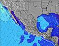 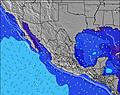 | 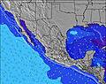 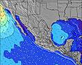  |    | 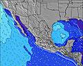 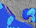 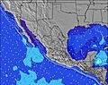 | ||||||||||||||||||||||||||||||||||||||||||||||||||||
| Wave Height (m) & direction (?) | ||||||||||||||||||||||||||||||||||||||||||||||||||||||||||||
| Period(s) (?) | 14 | 14 | 14 | 14 | 13 | 13 | 18 | 18 | 18 | 18 | 18 | 18 | 18 | 18 | 16 | 17 | 16 | 16 | 16 | 16 | 16 | 16 | 16 | 16 | 16 | 16 | 16 | 16 | 16 | 16 | 17 | 17 | 17 | 16 | 16 | 16 | 16 | 16 | 16 | 16 | 16 | 11 | 15 | 15 | 15 | 15 | 15 | 15 | 15 | 18 | 18 | 14 | 18 | 18 | 18 | 18 | 8 | 9 | 9 | 9 |
Wave (?)Graph | ||||||||||||||||||||||||||||||||||||||||||||||||||||||||||||
| Energy (?) | 289 | 277 | 265 | 261 | 257 | 257 | 255 | 323 | 323 | 404 | 491 | 326 | 322 | 318 | 169 | 220 | 422 | 499 | 493 | 590 | 346 | 186 | 157 | 161 | 198 | 196 | 248 | 248 | 201 | 261 | 563 | 399 | 220 | 206 | 371 | 366 | 248 | 322 | 248 | 245 | 248 | 214 | 183 | 178 | 150 | 181 | 150 | 174 | 174 | 159 | 155 | 103 | 154 | 249 | 449 | 366 | 330 | 499 | 554 | 567 |
Wind (km/h) | ||||||||||||||||||||||||||||||||||||||||||||||||||||||||||||
| Wind State (?) onshore cross-onshore cross-shore cross-offshore offshore glassy | cross- on | cross | cross | cross | cross | cross | cross- off | cross- on | cross | cross- on | cross | glass | cross- off | cross | glass | on | cross- on | cross- on | glass | glass | glass | glass | glass | on | on | cross- on | cross- on | cross | glass | cross | cross | cross- on | cross- on | cross | cross | cross | cross | cross- off | glass | cross- on | cross | cross | cross | cross | cross | cross | cross- on | cross- on | cross- on | cross | cross- on | cross- on | cross- on | on | on | on | cross- on | cross- on | cross | cross- on |
High Tide / height (m) | 8:00PM 1.82 | 7:49AM 1.75 | 8:17PM 1.91 | 8:26AM 1.74 | 8:35PM 1.98 | 9:03AM 1.71 | 8:54PM 2.05 | 9:40AM 1.66 | 9:15PM 2.09 | 10:19AM 1.58 | 9:38PM 2.11 | 11:00AM 1.48 | 10:03PM 2.11 | 11:47AM 1.38 | 10:32PM 2.08 | |||||||||||||||||||||||||||||||||||||||||||||
Low Tide / height (m) | 1:34PM 0.51 | 1:59AM 0.76 | 1:58PM 0.56 | 2:29AM 0.61 | 2:21PM 0.62 | 3:00AM 0.49 | 2:43PM 0.70 | 3:32AM 0.39 | 3:04PM 0.80 | 4:05AM 0.33 | 3:25PM 0.89 | 4:41AM 0.32 | 3:44PM 0.99 | 5:20AM 0.34 | 4:02PM 1.07 | |||||||||||||||||||||||||||||||||||||||||||||
Friday 19 | Saturday 20 | Sunday 21 | Monday 22 | Tuesday 23 | Wednesday 24 | Thursday 25 | Friday 26 | |||||||||||||||||||||||||||||||||||||||||||||||||||||
| Sunrise | - | - | - | - | - | - | 6:11 | - | - | - | - | - | - | - | 6:11 | - | - | - | - | - | - | - | 6:09 | - | - | - | - | - | - | - | 6:07 | - | - | - | - | - | - | - | 6:07 | - | - | - | - | - | - | - | 6:05 | - | - | - | - | - | - | - | 6:05 | - | - | - | - | - |
| Sunset | - | 7:20 | - | - | - | - | - | - | - | 7:20 | - | - | - | - | - | - | - | 7:21 | - | - | - | - | - | - | - | 7:22 | - | - | - | - | - | - | - | 7:22 | - | - | - | - | - | - | - | 7:22 | - | - | - | - | - | - | - | 7:23 | - | - | - | - | - | - | - | 7:24 | - | - |
Rain (mm) | - | - | - | - | - | - | - | - | - | - | - | - | - | - | - | - | - | - | - | - | - | - | - | - | - | - | - | - | - | - | - | - | - | - | - | - | - | - | - | - | - | - | - | - | - | - | - | - | - | - | - | - | - | - | - | - | - | - | - | - |
| Temp. °C | 16 | 16 | 14 | 14 | 13 | 13 | 14 | 17 | 17 | 16 | 14 | 15 | 14 | 15 | 16 | 18 | 19 | 18 | 16 | 16 | 16 | 15 | 16 | 18 | 18 | 17 | 15 | 14 | 14 | 14 | 14 | 17 | 17 | 16 | 15 | 14 | 13 | 13 | 14 | 16 | 16 | 15 | 14 | 14 | 14 | 14 | 14 | 15 | 15 | 15 | 14 | 14 | 14 | 13 | 14 | 15 | 15 | 15 | 15 | 14 |
| Feels °C (?) | 13 | 14 | 12 | 13 | 12 | 12 | 13 | 15 | 15 | 14 | 13 | 15 | 13 | 15 | 16 | 17 | 18 | 18 | 17 | 17 | 16 | 15 | 16 | 17 | 17 | 16 | 14 | 14 | 14 | 13 | 13 | 14 | 15 | 13 | 13 | 12 | 11 | 12 | 14 | 13 | 12 | 10 | 10 | 10 | 11 | 12 | 12 | 12 | 11 | 11 | 12 | 13 | 13 | 12 | 13 | 13 | 12 | 12 | 13 | 13 |
FREE! Surf-Forecast.com widget for your website
The surf report / weather widget below is available to embed on third party websites free of charge and provides a summary of our Dunes surf forecast. Simply grab the html code snippet that we provide and paste it into your own site. You can choose your preferred language and metric/imperial units for the surf forecast feed to suit users of your site. Click here to get the code.


 Nearest