

- Forecast
- Maps
- Live
- Weather State
- Spot Information
Kerloch Surf Forecast
/ Brittany – Finistere (75 surf breaks) /
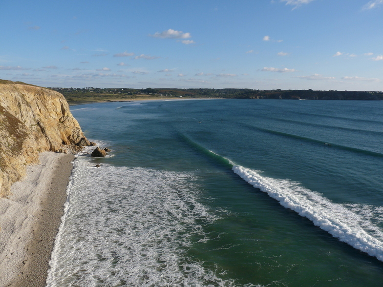

Kerloch surf Forecast / Brittany – Finistere / France
- Map Icons:
 Break
Break Live Wave Height (m)
 Live Wind Speed (km/h)
 Surf Rating (10 Max)
 Ocean Swells (m)
- Wind Speed (km/h)
How big are the waves at Kerloch today?
The current surf forecast for Kerloch at 8PM is: 0.7m 13s primary swell from a West-northwest direction and 1.1m 8s secondary swell from a Northwest direction (forecast issued at 07:00pm April 18). An open ocean swell of 0.2m 2s is not directed at the surf break. The wind direction is predicted to be cross-offshore and the swell rating is 2.
| Time (CEST) & Date | Wave Height | Wave Period |
|---|---|---|
| Morning (18 Apr) | - | - |
| Afternoon (18 Apr) | 4.5ft (1.3m) | 9s |
| Evening (18 Apr) | 2.5ft (0.7m) | 13s |
Table - waves today at Kerloch. (Swell directed towards the surf break)
Thursday 18 | Friday 19 | Saturday 20 | Sunday 21 | Monday 22 | Tuesday 23 | Wednesday 24 | Thursday 25 | Fri 26 | ||||||||||||||||||||||||||||||||||||||||||||||||||||
| 5 PM | 8 PM | 11 PM | 2 AM | 5 AM | 8 AM | 11 AM | 2 PM | 5 PM | 8 PM | 11 PM | 2 AM | 5 AM | 8 AM | 11 AM | 2 PM | 5 PM | 8 PM | 11 PM | 2 AM | 5 AM | 8 AM | 11 AM | 2 PM | 5 PM | 8 PM | 11 PM | 2 AM | 5 AM | 8 AM | 11 AM | 2 PM | 5 PM | 8 PM | 11 PM | 2 AM | 5 AM | 8 AM | 11 AM | 2 PM | 5 PM | 8 PM | 11 PM | 2 AM | 5 AM | 8 AM | 11 AM | 2 PM | 5 PM | 8 PM | 11 PM | 2 AM | 5 AM | 8 AM | 11 AM | 2 PM | 5 PM | 8 PM | 11 PM | 2 AM | |
Rating (10 max) | ||||||||||||||||||||||||||||||||||||||||||||||||||||||||||||
Swell Height Map |    |    |    |    |   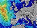 |  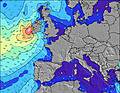 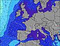 |  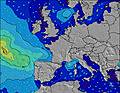  |    |    | |||||||||||||||||||||||||||||||||||||||||||||||||||
| Wave Height (m) & direction (?) | ||||||||||||||||||||||||||||||||||||||||||||||||||||||||||||
| Period(s) (?) | 8 | 13 | 13 | 13 | 12 | 12 | 12 | 12 | 12 | 12 | 12 | 11 | 11 | 11 | 11 | 11 | 11 | 10 | 10 | 10 | 10 | 10 | 10 | 10 | 10 | 10 | 10 | 10 | 10 | 9 | 9 | 9 | 9 | 12 | 11 | 18 | 11 | 11 | 12 | 12 | 10 | 10 | 10 | 9 | 9 | 9 | 9 | 9 | 5 | 9 | 9 | 9 | 9 | 9 | 9 | 8 | 8 | 8 | 8 | 8 |
Wave (?)Graph | ||||||||||||||||||||||||||||||||||||||||||||||||||||||||||||
| Energy (?) | 176 | 178 | 176 | 218 | 433 | 359 | 347 | 336 | 359 | 359 | 303 | 233 | 229 | 194 | 133 | 133 | 90 | 63 | 58 | 33 | 33 | 19 | 19 | 17 | 8 | 8 | 7 | 7 | 7 | 7 | 7 | 7 | 2 | 3 | 3 | 6 | 9 | 9 | 12 | 14 | 18 | 17 | 31 | 27 | 26 | 27 | 27 | 27 | 41 | 26 | 25 | 25 | 25 | 24 | 24 | 22 | 22 | 12 | 12 | 11 |
Wind (km/h) | ||||||||||||||||||||||||||||||||||||||||||||||||||||||||||||
| Wind State (?) onshore cross-onshore cross-shore cross-offshore offshore glassy | cross | cross- off | cross- off | cross | cross | cross | cross | cross | cross- off | cross- off | cross- off | cross- off | off | off | cross- off | cross- off | off | off | off | cross- off | cross- off | off | off | off | off | off | off | off | off | off | off | off | off | off | off | cross- off | cross- off | off | off | cross | cross | cross | cross | cross- off | cross | cross | cross- off | cross | cross | cross | cross | cross- on | cross- on | cross- on | cross | cross- off | off | cross- off | cross- off | cross- off |
High Tide / height (m) | 2:53PM 3.85 | 3:10AM 4.14 | 3:38PM 4.17 | 3:50AM 4.45 | 4:13PM 4.49 | 4:24AM 4.74 | 4:43PM 4.78 | 4:55AM 4.98 | 5:12PM 5.03 | 5:25AM 5.16 | 5:41PM 5.20 | 5:55AM 5.26 | 6:10PM 5.29 | 6:25AM 5.26 | 6:40PM 5.29 | |||||||||||||||||||||||||||||||||||||||||||||
Low Tide / height (m) | 8:53PM 1.77 | 9:25AM 1.46 | 9:41PM 1.46 | 10:04AM 1.15 | 10:18PM 1.15 | 10:38AM 0.87 | 10:51PM 0.87 | 11:09AM 0.65 | 11:23PM 0.65 | 11:38AM 0.51 | 11:53PM 0.51 | 12:08PM 0.45 | 12:23AM 0.46 | 12:37PM 0.48 | 12:54AM 0.50 | |||||||||||||||||||||||||||||||||||||||||||||
Thursday 18 | Friday 19 | Saturday 20 | Sunday 21 | Monday 22 | Tuesday 23 | Wednesday 24 | Thursday 25 | Fri 26 | ||||||||||||||||||||||||||||||||||||||||||||||||||||
| Sunrise | - | - | - | - | - | 7:20 | - | - | - | - | - | - | - | 7:18 | - | - | - | - | - | - | - | 7:16 | - | - | - | - | - | - | - | 7:13 | - | - | - | - | - | - | - | 7:11 | - | - | - | - | - | - | - | 7:09 | - | - | - | - | - | - | - | 7:09 | - | - | - | - | - | - |
| Sunset | - | 9:13 | - | - | - | - | - | - | - | 9:15 | - | - | - | - | - | - | - | 9:15 | - | - | - | - | - | - | - | 9:17 | - | - | - | - | - | - | - | 9:19 | - | - | - | - | - | - | - | 9:21 | - | - | - | - | - | - | - | 9:22 | - | - | - | - | - | - | - | 9:23 | - | - |
Rain (mm) | - | - | - | - | - | - | - | - | - | - | - | - | - | - | - | - | - | - | - | - | - | - | - | - | - | - | - | - | - | - | - | - | - | - | - | - | - | - | 1 | - | - | - | - | - | - | - | 1 | - | - | - | - | - | 1 | 1 | 1 | 1 | - | - | - | - |
| Temp. °C | 11 | 10 | 8 | 8 | 9 | 9 | 10 | 11 | 12 | 12 | 12 | 11 | 10 | 9 | 9 | 12 | 13 | 10 | 7 | 7 | 7 | 8 | 9 | 11 | 10 | 8 | 8 | 9 | 9 | 8 | 9 | 10 | 10 | 8 | 9 | 9 | 9 | 8 | 7 | 8 | 8 | 9 | 10 | 10 | 11 | 11 | 12 | 11 | 11 | 11 | 11 | 11 | 11 | 11 | 11 | 9 | 8 | 9 | 8 | 8 |
| Feels °C (?) | 7 | 5 | 5 | 6 | 5 | 4 | 6 | 7 | 7 | 7 | 8 | 7 | 6 | 5 | 4 | 8 | 8 | 3 | 1 | 2 | 3 | 5 | 4 | 3 | 2 | -1 | 2 | 3 | 3 | 2 | 2 | 2 | 1 | 0 | 3 | 4 | 4 | 3 | 5 | 6 | 5 | 6 | 7 | 6 | 6 | 5 | 6 | 4 | 4 | 4 | 5 | 5 | 5 | 6 | 6 | 4 | 1 | 2 | 2 | 4 |
FREE! Surf-Forecast.com widget for your website
The surf report / weather widget below is available to embed on third party websites free of charge and provides a summary of our Kerloch surf forecast. Simply grab the html code snippet that we provide and paste it into your own site. You can choose your preferred language and metric/imperial units for the surf forecast feed to suit users of your site. Click here to get the code.


 Nearest