

- Forecast
- Maps
- Live
- Weather State
- Spot Information

Surf Forecasts
Reef
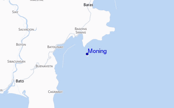
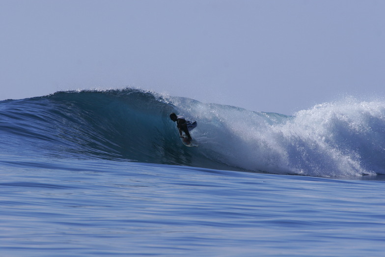
Moning surf Forecast / Catanduanes / Philippines
48hr Weather and Surf, issued 1 am Tuesday 16 Apr 2024 PST
Forecast update in hr min s Update imminent
Moning surf forecast is for near shore open water. Breaking waves will often be smaller at less exposed spots.
Today's Moning sea temperature is 28.7°C (Statistics for 16 Apr 1981-2005 - mean: 28.4 °C max: 29.6 °C min: 27.6 °C)
- Map Icons:
 Break
Break Live Wave Height (m)
 Live Wind Speed (km/h)
 Surf Rating (10 Max)
 Ocean Swells (m)
- Wind Speed (km/h)
Moning surf forecast is for near shore open water. Breaking waves will often be smaller at less exposed spots.
Today's Moning sea temperature is 28.7°C (Statistics for 16 Apr 1981-2005 - mean: 28.4 °C max: 29.6 °C min: 27.6 °C)
How big are the waves at Moning today?
The current surf forecast for Moning at 2PM is: 1.3m 11s primary swell from a East-northeast direction and 0.3m 12s secondary swell from a East-southeast direction (forecast issued at 01:00am April 16). The wind direction is predicted to be onshore.
| Time (PST) & Date | Wave Height | Wave Period |
|---|---|---|
| Morning (16 Apr) | 4.5ft (1.3m) | 11s |
| Afternoon (16 Apr) | 4.5ft (1.3m) | 11s |
| Evening (16 Apr) | 4.5ft (1.3m) | 11s |
Table - waves today at Moning. (Swell directed towards the surf break)
Updates in hr min s Update imminent
Tuesday 16 | Wednesday 17 | Thursday 18 | Friday 19 | Saturday 20 | Sunday 21 | Monday 22 | Tuesday 23 | |||||||||||||||||||||||||||||||||||||||||||||||||||||
| 11 PM | 2 AM | 5 AM | 8 AM | 11 AM | 2 PM | 5 PM | 8 PM | 11 PM | 2 AM | 5 AM | 8 AM | 11 AM | 2 PM | 5 PM | 8 PM | 11 PM | 2 AM | 5 AM | 8 AM | 11 AM | 2 PM | 5 PM | 8 PM | 11 PM | 2 AM | 5 AM | 8 AM | 11 AM | 2 PM | 5 PM | 8 PM | 11 PM | 2 AM | 5 AM | 8 AM | 11 AM | 2 PM | 5 PM | 8 PM | 11 PM | 2 AM | 5 AM | 8 AM | 11 AM | 2 PM | 5 PM | 8 PM | 11 PM | 2 AM | 5 AM | 8 AM | 11 AM | 2 PM | 5 PM | 8 PM | 11 PM | 2 AM | 5 AM | 8 AM | |
Rating (10 max) | ||||||||||||||||||||||||||||||||||||||||||||||||||||||||||||
Swell Height Map |  |  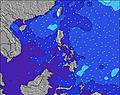 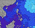 | 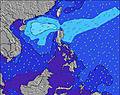 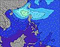 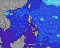 | 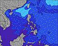 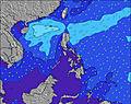 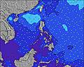 | 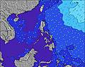 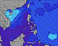 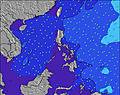 | 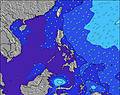 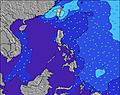 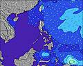 | 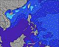 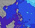 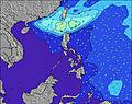 | 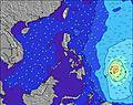 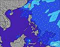 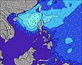 | 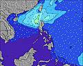 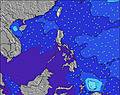 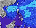 | |||||||||||||||||||||||||||||||||||||||||||||||||||
| Wave Height (m) & direction (?) | ||||||||||||||||||||||||||||||||||||||||||||||||||||||||||||
| Period(s) (?) | 11 | 11 | 11 | 11 | 11 | 11 | 11 | 11 | 11 | 11 | 11 | 10 | 11 | 10 | 10 | 10 | 10 | 10 | 10 | 10 | 10 | 10 | 11 | 11 | 11 | 11 | 11 | 11 | 11 | 11 | 13 | 13 | 13 | 13 | 13 | 13 | 13 | 13 | 13 | 13 | 12 | 12 | 12 | 12 | 12 | 12 | 12 | 12 | 12 | 12 | 12 | 11 | 11 | 12 | 12 | 12 | 12 | 11 | 10 | 10 |
Wave (?)Graph | ||||||||||||||||||||||||||||||||||||||||||||||||||||||||||||
| Energy (?) | 407 | 407 | 407 | 400 | 400 | 392 | 392 | 382 | 382 | 326 | 319 | 313 | 319 | 313 | 313 | 308 | 308 | 308 | 367 | 367 | 367 | 367 | 326 | 332 | 350 | 350 | 350 | 407 | 350 | 286 | 673 | 653 | 653 | 643 | 613 | 484 | 414 | 408 | 402 | 395 | 304 | 304 | 304 | 283 | 245 | 260 | 255 | 215 | 222 | 269 | 280 | 182 | 176 | 115 | 111 | 164 | 280 | 79 | 73 | 71 |
Wind (km/h) | ||||||||||||||||||||||||||||||||||||||||||||||||||||||||||||
| Wind State (?) onshore cross-onshore cross-shore cross-offshore offshore glassy | cross- on | on | on | on | on | on | cross- on | cross- on | on | on | on | cross- on | on | on | on | on | on | on | on | cross- on | on | on | on | on | on | on | on | on | on | on | on | on | on | on | on | on | on | on | on | on | on | on | cross- on | on | on | on | on | on | on | on | on | on | on | on | on | on | on | on | on | on |
High Tide / height (m) | 12:06AM 1.26 | 10:43AM 1.35 | 2:01AM 1.30 | 12:56PM 1.30 | 3:01AM 1.39 | 2:29PM 1.37 | 3:35AM 1.49 | 3:24PM 1.47 | 4:02AM 1.58 | 4:06PM 1.57 | 4:26AM 1.67 | 4:41PM 1.66 | 4:49AM 1.74 | 5:15PM 1.72 | 5:13AM 1.80 | |||||||||||||||||||||||||||||||||||||||||||||
Low Tide / height (m) | 4:51AM 1.07 | 6:26PM 0.65 | 7:26AM 1.06 | 8:01PM 0.64 | 8:50AM 0.93 | 9:00PM 0.59 | 9:33AM 0.77 | 9:40PM 0.54 | 10:05AM 0.62 | 10:13PM 0.50 | 10:34AM 0.48 | 10:42PM 0.48 | 11:02AM 0.34 | 11:10PM 0.48 | ||||||||||||||||||||||||||||||||||||||||||||||
Tuesday 16 | Wednesday 17 | Thursday 18 | Friday 19 | Saturday 20 | Sunday 21 | Monday 22 | Tuesday 23 | |||||||||||||||||||||||||||||||||||||||||||||||||||||
| Sunrise | - | - | - | 5:28 | - | - | - | - | - | - | - | 5:28 | - | - | - | - | - | - | - | 5:26 | - | - | - | - | - | - | - | 5:26 | - | - | - | - | - | - | - | 5:26 | - | - | - | - | - | - | - | 5:24 | - | - | - | - | - | - | - | 5:24 | - | - | - | - | - | - | - | 5:24 |
| Sunset | - | - | - | - | - | - | 5:54 | - | - | - | - | - | - | - | 5:54 | - | - | - | - | - | - | - | 5:55 | - | - | - | - | - | - | - | 5:55 | - | - | - | - | - | - | - | 5:55 | - | - | - | - | - | - | - | 5:55 | - | - | - | - | - | - | - | 5:55 | - | - | - | - | - |
Rain (mm) | - | - | - | - | - | - | - | - | - | - | - | - | - | - | - | - | - | - | - | 1 | 1 | - | - | - | - | - | - | - | - | - | - | - | - | - | - | - | - | - | - | - | - | - | - | - | - | - | - | - | - | - | - | - | - | - | - | - | - | - | - | 1 |
| Temp. °C | 26 | 27 | 26 | 28 | 29 | 29 | 28 | 26 | 26 | 26 | 26 | 27 | 28 | 29 | 28 | 27 | 27 | 26 | 26 | 27 | 28 | 29 | 28 | 27 | 27 | 27 | 27 | 28 | 29 | 29 | 28 | 27 | 27 | 27 | 27 | 28 | 29 | 29 | 28 | 27 | 27 | 27 | 27 | 28 | 29 | 29 | 28 | 27 | 27 | 27 | 26 | 28 | 29 | 29 | 28 | 27 | 27 | 28 | 27 | 28 |
| Feels °C (?) | 28 | 29 | 29 | 29 | 31 | 31 | 30 | 28 | 28 | 29 | 29 | 31 | 32 | 32 | 31 | 31 | 31 | 29 | 30 | 30 | 31 | 32 | 30 | 31 | 30 | 30 | 31 | 31 | 32 | 31 | 31 | 30 | 30 | 29 | 29 | 30 | 31 | 31 | 30 | 30 | 30 | 29 | 30 | 30 | 31 | 32 | 30 | 30 | 29 | 30 | 28 | 31 | 30 | 32 | 30 | 29 | 31 | 32 | 31 | 31 |
FREE! Surf-Forecast.com widget for your website
The surf report / weather widget below is available to embed on third party websites free of charge and provides a summary of our Moning surf forecast. Simply grab the html code snippet that we provide and paste it into your own site. You can choose your preferred language and metric/imperial units for the surf forecast feed to suit users of your site. Click here to get the code.


 Nearest