

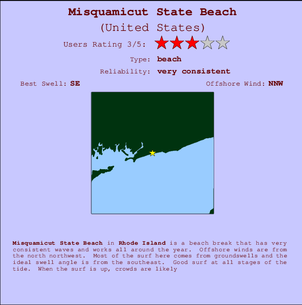
Misquamicut State Beach Surf Guide
Misquamicut State Beach in Rhode Island is a fairly exposed beach break that is often working and works all around the year. Offshore winds blow from the north northwest. Most of the surf here comes from groundswells and the ideal swell direction is from the southeast. Good surf at all stages of the tide. When the surf is up, crowds are likely
Misquamicut State Beach Spot Info
| Type: | Rating: | Reliability: | Todays Sea Temp*: |
|---|---|---|---|
| very consistent | 20.0°C*ocean temperature recorded from satellite |
Surfing Misquamicut State Beach:
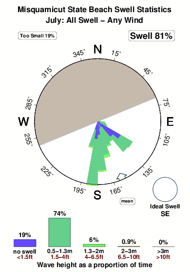
The best conditions reported for surf at Misquamicut State Beach occur when a Southeast swell combines with an offshore wind direction from the North-northwest.

Previsioni Energia d'onda (Potenza): 12hrs


Misquamicut State Beach Surf:
Friday, 17 July 2026, 06:44 Local time| Venerdì 17 | ||||
| 5AM | 8AM | 11AM | 2PM | |
| Wave (m) | ||||
| Periodo (s) | 5 | 5 | 5 | 6 |
| Vento (km/h) | ||||
| Stato del vento | off | off | cross- off |
cross |
- /breaks/Misquamicut-State-Beach/forecasts/latest
Misquamicut State Beach Surf Guide
Misquamicut State Beach in Rhode Island is a fairly exposed beach break that is often working and works all around the year. Offshore winds blow from the north northwest. Most of the surf here comes from groundswells and the ideal swell direction is from the southeast. Good surf at all stages of the tide. When the surf is up, crowds are likely
Misquamicut State Beach Spot Info
Type: Rating: Reliability: Todays Sea Temp*:  Beach
Beach 3
3very consistent 20.0°C*ocean temperature recorded from satelliteSurfing Misquamicut State Beach:
The best conditions reported for surf at Misquamicut State Beach occur when a Southeast swell combines with an offshore wind direction from the North-northwest.
Previsioni Energia d'onda (Potenza): 12hrs
Utilizzare la scheda di navigazione in alto per visualizzare Misquamicut State Beach temperatura del mare, Misquamicut State Beach fotografie, Misquamicut State Beach dettagliate previsioni onde, il vento e le previsioni meteo, Misquamicut State Beach webcam, vento corrente da Rhode Island stazioni meteo e Misquamicut State Beach previsioni marea. Il link United States mappe maree apre l'immagine grande, che mostra United States e dei mari circostanti. Queste mappe possono essere animate per mostrare le diverse componenti del moto ondoso, energia delle onde, periodo d'onda, altezza delle onde, insieme con le previsioni del vento e meteo, meteo corrente e osservazioni sullo stato del mare dal United States onda-boe, le navi passanti e stazioni meteo costiere. Ciascuna delle pagine di previsioni per questo surf break rappresenta uno strumento di wavefinder globale e regionale per individuare le migliori condizioni di surf nella zona intorno Misquamicut State Beach.
Misquamicut State Beach Surf:
Friday, 17 July 2026, 06:44 Local timeVenerdì 17 5AM 8AM 11AM 2PM Wave (m) Periodo (s) 5 5 5 6 Vento (km/h) Stato del vento off off cross-
offcross - /breaks/Misquamicut-State-Beach/forecasts/latest
- /breaks/Misquamicut-State-Beach/forecasts/latest/six_day
Misquamicut State Beach Surf Guide
Misquamicut State Beach in Rhode Island is a fairly exposed beach break that is often working and works all around the year. Offshore winds blow from the north northwest. Most of the surf here comes from groundswells and the ideal swell direction is from the southeast. Good surf at all stages of the tide. When the surf is up, crowds are likely
Misquamicut State Beach Spot Info
Type: Rating: Reliability: Todays Sea Temp*: Beach3very consistent 20.0°C*ocean temperature recorded from satelliteSurfing Misquamicut State Beach:
The best conditions reported for surf at Misquamicut State Beach occur when a Southeast swell combines with an offshore wind direction from the North-northwest.
Previsioni Energia d'onda (Potenza): 12hrs
Utilizzare la scheda di navigazione in alto per visualizzare Misquamicut State Beach temperatura del mare, Misquamicut State Beach fotografie, Misquamicut State Beach dettagliate previsioni onde, il vento e le previsioni meteo, Misquamicut State Beach webcam, vento corrente da Rhode Island stazioni meteo e Misquamicut State Beach previsioni marea. Il link United States mappe maree apre l'immagine grande, che mostra United States e dei mari circostanti. Queste mappe possono essere animate per mostrare le diverse componenti del moto ondoso, energia delle onde, periodo d'onda, altezza delle onde, insieme con le previsioni del vento e meteo, meteo corrente e osservazioni sullo stato del mare dal United States onda-boe, le navi passanti e stazioni meteo costiere. Ciascuna delle pagine di previsioni per questo surf break rappresenta uno strumento di wavefinder globale e regionale per individuare le migliori condizioni di surf nella zona intorno Misquamicut State Beach.
Misquamicut State Beach Surf:
Friday, 17 July 2026, 06:44 Local timeVenerdì 17 5AM 8AM 11AM 2PM Wave (m) Periodo (s) 5 5 5 6 Vento (km/h) Stato del vento off off cross-
offcross - /breaks/Misquamicut-State-Beach/forecasts/latest
Misquamicut State Beach Surf Guide
Misquamicut State Beach in Rhode Island is a fairly exposed beach break that is often working and works all around the year. Offshore winds blow from the north northwest. Most of the surf here comes from groundswells and the ideal swell direction is from the southeast. Good surf at all stages of the tide. When the surf is up, crowds are likely
Misquamicut State Beach Spot Info
Type: Rating: Reliability: Todays Sea Temp*: Beach3very consistent 20.0°C*ocean temperature recorded from satelliteSurfing Misquamicut State Beach:
The best conditions reported for surf at Misquamicut State Beach occur when a Southeast swell combines with an offshore wind direction from the North-northwest.
Previsioni Energia d'onda (Potenza): 12hrs
Utilizzare la scheda di navigazione in alto per visualizzare Misquamicut State Beach temperatura del mare, Misquamicut State Beach fotografie, Misquamicut State Beach dettagliate previsioni onde, il vento e le previsioni meteo, Misquamicut State Beach webcam, vento corrente da Rhode Island stazioni meteo e Misquamicut State Beach previsioni marea. Il link United States mappe maree apre l'immagine grande, che mostra United States e dei mari circostanti. Queste mappe possono essere animate per mostrare le diverse componenti del moto ondoso, energia delle onde, periodo d'onda, altezza delle onde, insieme con le previsioni del vento e meteo, meteo corrente e osservazioni sullo stato del mare dal United States onda-boe, le navi passanti e stazioni meteo costiere. Ciascuna delle pagine di previsioni per questo surf break rappresenta uno strumento di wavefinder globale e regionale per individuare le migliori condizioni di surf nella zona intorno Misquamicut State Beach.
Misquamicut State Beach Surf:
Friday, 17 July 2026, 06:44 Local timeVenerdì 17 5AM 8AM 11AM 2PM Wave (m) Periodo (s) 5 5 5 6 Vento (km/h) Stato del vento off off cross-
offcross Tide Times:
Per Weekapaug Point, Block Island Sound, Rhode Island, %{dist} %{km} da %{location}.
PROSSIMA È ALLE (ora locale) rimanente alta marea bassa marea Misquamicut State Beach Tide Times and Tide Chart
Live Weather:
At Westerly Airport, 3 km from Misquamicut State Beach.
calm
(km/h)
Mist -Air temperature
16.1°CCurrent weather near Misquamicut State Beach
Buoy Data:
At Block Island, RI, 42 miles from Misquamicut State Beach.
1AM 2AM 3AM 4AM Attualità dei dati 4 hr 3 hr 2 hr 1 hr Altezza delle onde (m) 


Periodo dominante (s) 6 6 6 6 Overall Misquamicut State Beach Surf Consistency and Wind Distribution in Luglio


Wind stats for Misquamicut State Beach: see the variation in direction and stength by month.
foto dall' album
Contorni: Strade e fiumi: seleziona un surf break dal menu 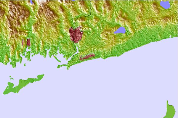
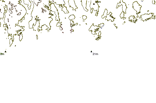
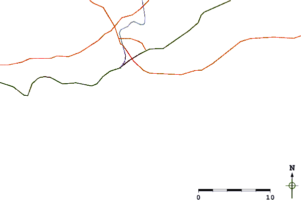
Utilizzare questa mappa sollievo per navigare Rhode Island surf breaks e stazioni di marea che si trovano nella zona diMisquamicut State Beach
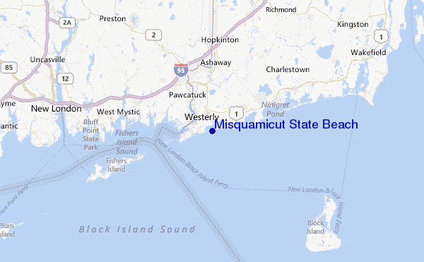
Altri surf breaks più vicini al Misquamicut State Beach:
(clicca sul nome del luogo per maggiori informazioni)- Closest località surf2 mi
- Second closest località surf2 mi
- Third closest località surf3 mi
- Fourth closest località surf4 mi
- Fifth closest località surf4 mi
Onda boe più vicina a Misquamicut State Beach:
- Closest Onda boa42 mi
- Second closest Onda boa46 mi
- Third closest Onda boa47 mi
- Fourth closest Onda boa84 mi
- Fifth closest Onda boa84 mi
Stazioni di marea più vicina alla Misquamicut State Beach:
- Closest marea stazioneWeekapaug Point, Block Island Sound2 mi
- Second closest marea stazioneWatch Hill Point4 mi
- Third closest marea stazioneWesterly, Pawcatuck River4 mi
- Fourth closest marea stazioneStonington, Fishers Island Sound6 mi
- Fifth closest marea stazioneCharlestown9 mi
Airports
- The closest passenger airport to Misquamicut State Beach is Theodore Francis Green State (Providence) Airport (PVD) in USA, 54 km (34 miles) away (directly).
- The second nearest airport to Misquamicut State Beach is North Central State (Smithfield) Airport (SFZ), also in USA, 71 km (44 miles) away.
- Third is Hartford Brainard Airport (HFD) in USA, 85 km (53 miles) away.
- The Francis S Gabreski (West Hampton Beach) Airport (FOK) in USA is 88 km (55 miles) away.
- Bradley International (Windsor Locks) Airport (BDL), also in USA is the fifth nearest airport to Misquamicut State Beach and is 101 km (63 miles) away.
- /breaks/Misquamicut-State-Beach/forecasts/latest


 Nearest