- Forecast
- Maps
- Live
- Weather State
- Spot Information

Previsioni
Surf a FurnasPrevisione / Ericeira / Portugal
Aggiornamento meteo in hr min s Forecast update imminent
Questi sono altezze d'onde di mare aperto. Onde che si infrangono di solito sono più piccole, specialmente in luoghi riparati.
La temperatura del mare a Furnas oggi è
18.3° C
(Che è 1.7°C più freddo della media per questo periodo dell'anno)Aggiornamento in hr min s Forecast update imminent
Domenica 27 | Lunedì 28 | Martedì 29 | ||||||||||||||||||||||
| 10 PM | 1 AM | 4 AM | 7 AM | 10 AM | 1 PM | 4 PM | 7 PM | 10 PM | 1 AM | 4 AM | 7 AM | 10 AM | 1 PM | 4 PM | 7 PM | 10 PM | 1 AM | 4 AM | 7 AM | 10 AM | 1 PM | 4 PM | 7 PM | |
Voto (10 max) | ||||||||||||||||||||||||
Mappa dell'altezza del moto ondoso |  |  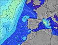 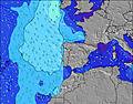 |  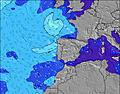 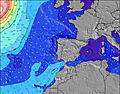 |  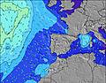 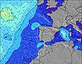 | ||||||||||||||||||||
| Le onde più grandi (m) & direzione (?) | ||||||||||||||||||||||||
| Periodo(s) (?) | 8 | 8 | 12 | 8 | 8 | 8 | 11 | 11 | 11 | 7 | 7 | 7 | 7 | 7 | 7 | 8 | 8 | 9 | 9 | 9 | 9 | 9 | 9 | 9 |
Grafico (?)delle onde | ||||||||||||||||||||||||
| Energia (?) | 467 | 480 | 557 | 578 | 622 | 591 | 575 | 538 | 470 | 501 | 615 | 560 | 582 | 548 | 513 | 528 | 663 | 864 | 1096 | 1303 | 1060 | 878 | 757 | 707 |
Vento (km/h) | ||||||||||||||||||||||||
| Stato del vento (?) onshore cross-onshore cross-shore cross-offshore offshore piatto | cross | cross | cross | cross | cross | cross | cross | cross | cross | cross | cross | cross | cross | cross | cross | cross | cross | cross | cross | cross- off | cross- off | cross | cross | cross |
Alta Marea / altezza (m) | 5:03AM 2.68 | 5:18PM 2.98 | 5:41AM 2.61 | 5:55PM 2.85 | 6:18AM 2.51 | 6:33PM 2.69 | ||||||||||||||||||
Basso Marea / altezza (m) | 10:55PM 0.11 | 10:59AM 0.25 | 11:33PM 0.19 | 11:37AM 0.33 | 12:09AM 0.31 | 12:14PM 0.45 | ||||||||||||||||||
Domenica 27 | Lunedì 28 | Martedì 29 | ||||||||||||||||||||||
| Alba | - | - | - | 6:33 | - | - | - | - | - | - | - | 6:33 | - | - | - | - | - | - | - | 6:35 | - | - | - | - |
| Tramonto | - | - | - | - | - | - | - | 8:53 | - | - | - | - | - | - | - | 8:52 | - | - | - | - | - | - | - | 8:52 |
Piog. (mm) | - | - | - | - | - | - | - | - | - | - | - | - | - | - | - | - | - | - | - | - | - | - | - | - |
| Temp. °C | 21 | 19 | 18 | 17 | 19 | 21 | 20 | 19 | 18 | 17 | 17 | 17 | 18 | 19 | 19 | 19 | 18 | 19 | 18 | 21 | 27 | 30 | 28 | 25 |
| Feels °C (?) | 19 | 17 | 16 | 16 | 17 | 18 | 16 | 15 | 14 | 13 | 13 | 12 | 14 | 15 | 15 | 15 | 16 | 17 | 17 | 20 | 23 | 26 | 23 | 20 |
- Map Icons:
 Break
Break Live Wave Height (m)
 Live Wind Speed (km/h)
 Surf Rating (10 Max)
 Ocean Swells (m)
- Wind Speed (km/h)
 Recenti Eyeball Surf Report per Ericeira

Expand
<
>
View all
2 h 54 min ago
25 km/h
NNW
Cross-On
Please reload the page to see if there are any updates.
Widget Free Surf-Forecast.com per il tuo sito
La relazione di surf / widget meteo è disponibile qui sotto per incorporare su siti esterni a titolo gratuito e fornisce una sintesi delle nostre Furnas previsione surf. Basta prendere il frammento di codice html da noi fornito e copiarlo nel proprio sito. È possibile scegliere la lingua preferita e unità metriche / imperiali per il feed delle previsioni surf per soddisfare le esigenze degli utenti del vostro sito .... Clicca qui per ottenere il codice.


 Nearest