
Previsioni:

Previsione a breve terminePioggia abbondante (Totale 105mm), più pesante durante domenica mattina. Warm (Max 24°C Venerdì mattina, Min 20°C Sabato notte). Vento sarà generalmente leggero. | ||||||||||||||||||||||||
Venerdì 17 | Sabato 18 | Domenica 19 | ||||||||||||||||||||||
2 AM | 5 AM | 8 AM | 11 AM | 2 PM | 5 PM | 8 PM | 11 PM | 2 AM | 5 AM | 8 AM | 11 AM | 2 PM | 5 PM | 8 PM | 11 PM | 2 AM | 5 AM | 8 AM | 11 AM | 2 PM | 5 PM | 8 PM | 11 PM | |
Mappa dell'altezza del moto ondoso |  | 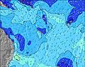 | 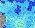 | 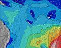 | 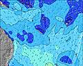 | 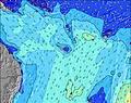 | 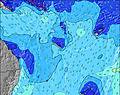 | 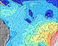 | 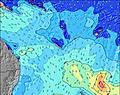 | |||||||||||||||
Onda Altezza (m) Direzione Periodo (s) | SSW 13 | SSW 13 | SSW 13 | SSW 12 | SSW 12 | SSW 12 | SSW 11 | SW 11 | SW 10 | SSW 18 | SSW 18 | SSW 17 | SSW 17 | SSW 17 | SSW 16 | SSW 16 | SSW 15 | SSW 15 | SSW 22 | SSW 21 | SSW 21 | SSW 21 | SSW 20 | SSW 20 |
Grafico delle onde | ||||||||||||||||||||||||
434 | 421 | 330 | 255 | 247 | 239 | 215 | 229 | 216 | 352 | 582 | 673 | 827 | 969 | 880 | 697 | 679 | 683 | 503 | 979 | 1410 | 1781 | 2271 | 2160 | |
Vento (km/h) | ||||||||||||||||||||||||
Stato del vento onshore cross-onshore cross-shore cross-offshore offshore piatto | cross-off | off | off | off | off | off | off | off | off | off | off | off | off | off | off | cross-off | cross-off | cross-off | glassy | cross-off | cross-off | cross-off | off | cross-off |
Alta Marea | 7:27AM1.20m | 8:58PM1.28m | 8:24AM1.13m | 9:41PM1.26m | 9:25AM1.05m | 10:23PM1.23m | ||||||||||||||||||
Basso Marea | 1:49AM0.55m | 2:04PM0.04m | 2:45AM0.52m | 2:50PM0.16m | 3:43AM0.50m | 3:36PM0.29m | ||||||||||||||||||
— | 6:35 | — | — | — | — | — | — | — | 6:35 | — | — | — | — | — | — | — | 6:35 | — | — | — | — | — | — | |
— | — | — | — | — | 5:31 | — | — | — | — | — | — | — | 5:32 | — | — | — | — | — | — | — | 5:32 | — | — | |
mm | — | — | — | — | — | — | — | — | — | — | — | — | 1 | 2 | 10 | 12 | 15 | 19 | 20 | 17 | 6 | 3 | — | — |
Temp. °C | 20 | 21 | 21 | 24 | 24 | 24 | 22 | 22 | 22 | 22 | 22 | 23 | 22 | 22 | 21 | 21 | 20 | 20 | 20 | 21 | 20 | 20 | 20 | 20 |
Gelo °C | 21 | 21 | 21 | 23 | 23 | 23 | 23 | 23 | 23 | 23 | 23 | 24 | 23 | 24 | 23 | 23 | 22 | 22 | 23 | 23 | 22 | 20 | 21 | 21 |
Onda 1 Altezza (m) Direzione Periodo (s) | SSW 13 | SSW 13 | SSW 13 | SSW 12 | SSW 12 | SSW 12 | SSW 11 | SW 11 | SW 10 | SW 10 | SW 10 | SSW 17 | SSW 17 | SSW 17 | SSW 16 | SSW 16 | SSW 15 | SSW 15 | SSW 15 | SSW 21 | SSW 21 | SSW 21 | SSW 20 | SSW 20 |
434 | 421 | 330 | 255 | 247 | 239 | 215 | 229 | 216 | 200 | 196 | 673 | 827 | 969 | 880 | 697 | 679 | 683 | 405 | 979 | 1410 | 1781 | 2271 | 2160 | |
Onda 2 Altezza (m) Direzione Periodo (s) | SE 9 | SE 9 | SSW 16 | SSW 16 | SSW 16 | SSW 16 | SE 8 | SE 8 | SSW 19 | SSW 18 | SSW 18 | SW 10 | SW 10 | SW 9 | SW 9 | SW 9 | SW 9 | SE 16 | SSW 22 | SSW 14 | SSW 14 | SSW 14 | SE 7 | SE 7 |
27 | 27 | 155 | 103 | 98 | 94 | 18 | 18 | 199 | 352 | 582 | 163 | 134 | 123 | 84 | 84 | 86 | 206 | 503 | 297 | 229 | 312 | 194 | 118 | |
Onda 3 Altezza (m) Direzione Periodo (s) | — | — | SE 9 | SE 9 | SE 9 | SE 8 | SW 16 | SW 16 | SE 8 | ESE 8 | ESE 9 | ESE 9 | SE 18 | SE 17 | SE 17 | SE 16 | SE 16 | SSW 22 | SE 16 | SE 16 | SE 15 | SE 15 | SE 15 | SE 15 |
— | — | 20 | 19 | 19 | 18 | 62 | 61 | 18 | 27 | 32 | 33 | 111 | 190 | 181 | 219 | 257 | 283 | 201 | 239 | 233 | 183 | 181 | 178 | |
onde vento Altezza (m) Direzione Periodo (s) | — | — | NE 3 | NE 3 | NNE 3 | — | NE 3 | NE 3 | — | NNE 4 | NNE 4 | NNE 3 | NNE 3 | NNE 3 | — | NNE 3 | — | SE 3 | SE 4 | SE 5 | SE 5 | SE 6 | ESE 8 | — |
— | — | 3 | 2 | 1 | — | 2 | 4 | — | 11 | 12 | 7 | 4 | 6 | — | 4 | — | 6 | 36 | 35 | 28 | 96 | 667 | — | |
Il più vicino Offshore or Glassy | ||||||||||||||||||||||||
Distanza (km) | 0 | 0 | 0 | 0 | 0 | 0 | 0 | 0 | 0 | 0 | 0 | 0 | 0 | 0 | 0 | 0 | 0 | 0 | 0 | 0 | 0 | 0 | 0 | 0 |
Migliori previsioni per le condizioni d'onda in New Caledonia | ||||||||||||||||||||||||
Migliori previsioni per le condizioni d'onda in New Caledonia | ||||||||||||||||||||||||
Trova Onde Globale | ||||||||||||||||||||||||
- Map Icons:
 Break
Break Live Wave Height (m)
 Live Wind Speed (km/h)
 Surf Rating (10 Max)
 Ocean Swells (m)
- Wind Speed (km/h)
Widget Free Surf-Forecast.com per il tuo sito
La relazione di surf / widget meteo è disponibile qui sotto per incorporare su siti esterni a titolo gratuito e fornisce una sintesi delle nostre Green Island Left (Île Verte) previsione surf. Basta prendere il frammento di codice html da noi fornito e copiarlo nel proprio sito. È possibile scegliere la lingua preferita e unità metriche / imperiali per il feed delle previsioni surf per soddisfare le esigenze degli utenti del vostro sito .... Clicca qui per ottenere il codice.
 Nearest