
La Puntilla Surf Guide
La Puntilla in Guayas is an exposed reef break that does not work very often. Spring and Summer provide the best conditions. Offshore winds are from the south southwest. Most of the surf here comes from groundswells and the ideal swell direction is from the north. A reef breaks left. Unlikely to be too crowded, even when the surf is up. Beware of accessibility, rips and rocks.
La Puntilla Spot Info
| Type: | Rating: | Reliability: | Todays Sea Temp*: |
|---|---|---|---|
| inconsistent | 25.6°C*ocean temperature recorded from satellite |
Surfing La Puntilla:
The best conditions reported for surf at La Puntilla occur when a North swell combines with an offshore wind direction from the South-southwest.

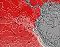
Previsioni Energia d'onda (Potenza): 12hrs
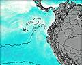

La Puntilla Surf:
Saturday, 18 July 2026, 03:44 Local time| Sabato 18 | ||||
| 4AM | 7AM | 10AM | 1PM | |
| Wave (m) | ||||
| Periodo (s) | 10 | - | - | - |
| Vento (km/h) | ||||
| Stato del vento | off | off | off | cross- off |
- /breaks/La-Puntilla_5/forecasts/latest
La Puntilla Surf Guide
La Puntilla in Guayas is an exposed reef break that does not work very often. Spring and Summer provide the best conditions. Offshore winds are from the south southwest. Most of the surf here comes from groundswells and the ideal swell direction is from the north. A reef breaks left. Unlikely to be too crowded, even when the surf is up. Beware of accessibility, rips and rocks.
La Puntilla Spot Info
Type: Rating: Reliability: Todays Sea Temp*:  Reef
Reef 3
3inconsistent 25.6°C*ocean temperature recorded from satelliteSurfing La Puntilla:
The best conditions reported for surf at La Puntilla occur when a North swell combines with an offshore wind direction from the South-southwest.
Previsioni Energia d'onda (Potenza): 12hrs
Utilizzare la scheda di navigazione in alto per visualizzare La Puntilla temperatura del mare, La Puntilla fotografie, La Puntilla dettagliate previsioni onde, il vento e le previsioni meteo, La Puntilla webcam, vento corrente da Guayas stazioni meteo e La Puntilla previsioni marea. Il link Ecuador mappe maree apre l'immagine grande, che mostra Ecuador e dei mari circostanti. Queste mappe possono essere animate per mostrare le diverse componenti del moto ondoso, energia delle onde, periodo d'onda, altezza delle onde, insieme con le previsioni del vento e meteo, meteo corrente e osservazioni sullo stato del mare dal Ecuador onda-boe, le navi passanti e stazioni meteo costiere. Ciascuna delle pagine di previsioni per questo surf break rappresenta uno strumento di wavefinder globale e regionale per individuare le migliori condizioni di surf nella zona intorno La Puntilla.
La Puntilla Surf:
Saturday, 18 July 2026, 03:44 Local timeSabato 18 4AM 7AM 10AM 1PM Wave (m) Periodo (s) 10 - - - Vento (km/h) Stato del vento off off off cross-
off- /breaks/La-Puntilla_5/forecasts/latest
- /breaks/La-Puntilla_5/forecasts/latest/six_day
La Puntilla Surf Guide
La Puntilla in Guayas is an exposed reef break that does not work very often. Spring and Summer provide the best conditions. Offshore winds are from the south southwest. Most of the surf here comes from groundswells and the ideal swell direction is from the north. A reef breaks left. Unlikely to be too crowded, even when the surf is up. Beware of accessibility, rips and rocks.
La Puntilla Spot Info
Type: Rating: Reliability: Todays Sea Temp*: Reef3inconsistent 25.6°C*ocean temperature recorded from satelliteSurfing La Puntilla:
The best conditions reported for surf at La Puntilla occur when a North swell combines with an offshore wind direction from the South-southwest.
Previsioni Energia d'onda (Potenza): 12hrs
Utilizzare la scheda di navigazione in alto per visualizzare La Puntilla temperatura del mare, La Puntilla fotografie, La Puntilla dettagliate previsioni onde, il vento e le previsioni meteo, La Puntilla webcam, vento corrente da Guayas stazioni meteo e La Puntilla previsioni marea. Il link Ecuador mappe maree apre l'immagine grande, che mostra Ecuador e dei mari circostanti. Queste mappe possono essere animate per mostrare le diverse componenti del moto ondoso, energia delle onde, periodo d'onda, altezza delle onde, insieme con le previsioni del vento e meteo, meteo corrente e osservazioni sullo stato del mare dal Ecuador onda-boe, le navi passanti e stazioni meteo costiere. Ciascuna delle pagine di previsioni per questo surf break rappresenta uno strumento di wavefinder globale e regionale per individuare le migliori condizioni di surf nella zona intorno La Puntilla.
La Puntilla Surf:
Saturday, 18 July 2026, 03:44 Local timeSabato 18 4AM 7AM 10AM 1PM Wave (m) Periodo (s) 10 - - - Vento (km/h) Stato del vento off off off cross-
off- /breaks/La-Puntilla_5/forecasts/latest
La Puntilla Surf Guide
La Puntilla in Guayas is an exposed reef break that does not work very often. Spring and Summer provide the best conditions. Offshore winds are from the south southwest. Most of the surf here comes from groundswells and the ideal swell direction is from the north. A reef breaks left. Unlikely to be too crowded, even when the surf is up. Beware of accessibility, rips and rocks.
La Puntilla Spot Info
Type: Rating: Reliability: Todays Sea Temp*: Reef3inconsistent 25.6°C*ocean temperature recorded from satelliteSurfing La Puntilla:
The best conditions reported for surf at La Puntilla occur when a North swell combines with an offshore wind direction from the South-southwest.
Previsioni Energia d'onda (Potenza): 12hrs
Utilizzare la scheda di navigazione in alto per visualizzare La Puntilla temperatura del mare, La Puntilla fotografie, La Puntilla dettagliate previsioni onde, il vento e le previsioni meteo, La Puntilla webcam, vento corrente da Guayas stazioni meteo e La Puntilla previsioni marea. Il link Ecuador mappe maree apre l'immagine grande, che mostra Ecuador e dei mari circostanti. Queste mappe possono essere animate per mostrare le diverse componenti del moto ondoso, energia delle onde, periodo d'onda, altezza delle onde, insieme con le previsioni del vento e meteo, meteo corrente e osservazioni sullo stato del mare dal Ecuador onda-boe, le navi passanti e stazioni meteo costiere. Ciascuna delle pagine di previsioni per questo surf break rappresenta uno strumento di wavefinder globale e regionale per individuare le migliori condizioni di surf nella zona intorno La Puntilla.
La Puntilla Surf:
Saturday, 18 July 2026, 03:44 Local timeSabato 18 4AM 7AM 10AM 1PM Wave (m) Periodo (s) 10 - - - Vento (km/h) Stato del vento off off off cross-
offTide Times:
Per Salinas, %{dist} %{km} da %{location}.
PROSSIMA È ALLE (ora locale) rimanente alta marea bassa marea La Puntilla Tide Times and Tide Chart
Live Weather:
At Guayaquil/José Joaquín de Olmedo International Airport, 124 km from La Puntilla.
light winds from the SW.(Wind varies from 200 to 260 degs)
(km/h)
Dry and partly cloudyAir temperature
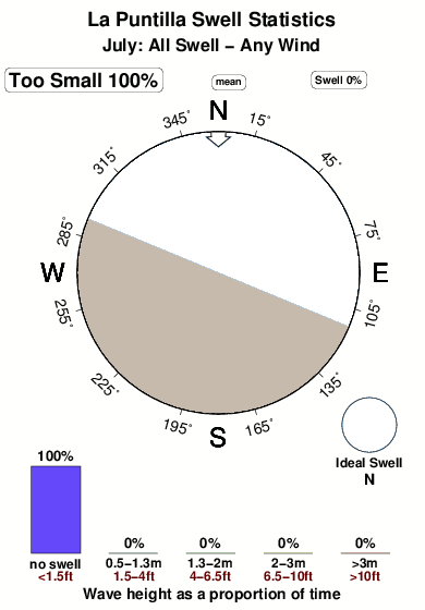
25°COverall La Puntilla Surf Consistency and Wind Distribution in Luglio
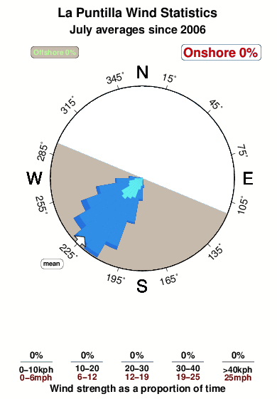

Wind stats for La Puntilla: see the variation in direction and stength by month.
foto dall' album
Contorni: Strade e fiumi: seleziona un surf break dal menu 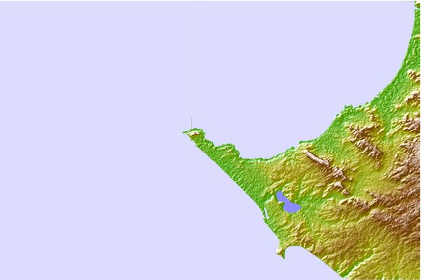
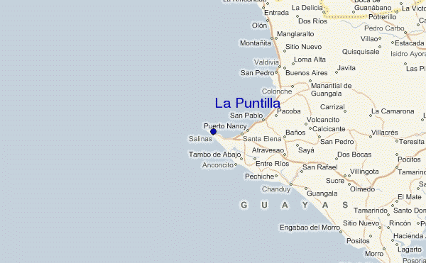
Utilizzare questa mappa sollievo per navigare Guayas surf breaks e stazioni di marea che si trovano nella zona diLa Puntilla
Altri surf breaks più vicini al La Puntilla:
(clicca sul nome del luogo per maggiori informazioni)- Closest località surf1 mi
- Second closest località surf1 mi
- Third closest località surf1 mi
- Fourth closest località surf3 mi
- Fifth closest località surf4 mi
Onda boe più vicina a La Puntilla:
- Closest Onda boa1223 mi
- Second closest Onda boa1316 mi
- Third closest Onda boa1550 mi
- Fourth closest Onda boa1700 mi
- Fifth closest Onda boa1700 mi
Stazioni di marea più vicina alla La Puntilla:
- Closest marea stazioneSalinas2 mi
- Second closest marea stazioneLa Libertad4 mi
- Third closest marea stazioneSanta Elena9 mi
- Fourth closest marea stazionePuerto Lopez45 mi
- Fifth closest marea stazionePlayas51 mi
Airports
- The closest passenger airport to La Puntilla is General Ulpiano Paez (Salinas) Airport (SNC) in Ecuador, 2 km (1 miles) away (directly).
- The second nearest airport to La Puntilla is Simon Bolivar International (Guayaquil) Airport (GYE), also in Ecuador, 122 km (76 miles) away.
- Third is Reales Tamarindos (Portoviejo) Airport (PVO) in Ecuador, 140 km (87 miles) away.
- Eloy Alfaro International (Manta) Airport (MEC) in Ecuador is 143 km (89 miles) away.
- General Serrano (Machala) Airport (MCH), also in Ecuador is the fifth nearest airport to La Puntilla and is 164 km (102 miles) away.

- /breaks/La-Puntilla_5/forecasts/latest


 Nearest