- Forecast
- Maps
- Live
- Weather State
- Spot Information
Lampaul Ploudalmezeau Previsione surf
/ Brittany – Finistere (75 surf breaks) /Previsioni:

Surf a Lampaul PloudalmezeauPrevisione / Brittany – Finistere / France
Aggiornamento meteo in hr min s Forecast update imminent
Questi sono altezze d'onde di mare aperto. Onde che si infrangono di solito sono più piccole, specialmente in luoghi riparati.
La temperatura del mare a Lampaul Ploudalmezeau oggi è
16.5° C
(Che è leggermente più freddo del normale)Aggiornamento in hr min s Forecast update imminent
Domenica 07 | Lunedì 08 | Martedì 09 | Mer 10 | |||||||||||||||||||||
| 5 AM | 8 AM | 11 AM | 2 PM | 5 PM | 8 PM | 11 PM | 2 AM | 5 AM | 8 AM | 11 AM | 2 PM | 5 PM | 8 PM | 11 PM | 2 AM | 5 AM | 8 AM | 11 AM | 2 PM | 5 PM | 8 PM | 11 PM | 2 AM | |
Voto (10 max) | ||||||||||||||||||||||||
Mappa dell'altezza del moto ondoso |  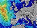 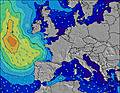 |  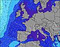 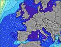 |  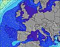 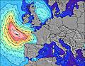 | 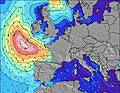 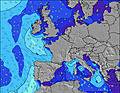 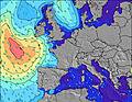 | ||||||||||||||||||||
| Le onde più grandi (m) & direzione (?) | ||||||||||||||||||||||||
| Periodo(s) (?) | 11 | 11 | 11 | 10 | 10 | 10 | 12 | 11 | 11 | 11 | 11 | 11 | 11 | 10 | 10 | 10 | 10 | 10 | 10 | 10 | 10 | 8 | 10 | 10 |
Grafico (?)delle onde | ||||||||||||||||||||||||
| Energia (?) | 142 | 225 | 1154 | 1263 | 1197 | 1211 | 1319 | 1218 | 1225 | 996 | 877 | 814 | 659 | 604 | 573 | 509 | 441 | 450 | 458 | 486 | 524 | 438 | 702 | 576 |
Vento (km/h) | ||||||||||||||||||||||||
| Stato del vento (?) onshore cross-onshore cross-shore cross-offshore offshore piatto | cross- off | cross- off | off | off | off | off | cross- off | cross- off | cross- off | cross- off | off | off | off | off | cross- off | cross- off | cross- off | cross- off | cross- off | cross- off | cross- off | cross- off | cross- off | off |
Alta Marea / altezza (m) | 6:15PM 6.83 | 6:37AM 6.79 | 6:51PM 7.19 | 7:12AM 7.07 | 7:28PM 7.36 | |||||||||||||||||||
Basso Marea / altezza (m) | 12:16PM 0.48 | 12:39AM 0.04 | 12:53PM 0.08 | 1:16AM -0.28 | 1:31PM -0.17 | 1:53AM -0.38 | ||||||||||||||||||
Domenica 07 | Lunedì 08 | Martedì 09 | Mer 10 | |||||||||||||||||||||
| Alba | - | 7:43 | - | - | - | - | - | - | - | 7:43 | - | - | - | - | - | - | - | 7:46 | - | - | - | - | - | - |
| Tramonto | - | - | - | - | - | 8:49 | - | - | - | - | - | - | - | 8:46 | - | - | - | - | - | - | - | 8:45 | - | - |
Piog. (mm) | - | - | 3 | 1 | - | 1 | - | - | - | - | - | - | - | - | - | - | 1 | - | - | - | - | - | - | 1 |
| Temp. °C | 18 | 18 | 18 | 18 | 18 | 16 | 16 | 15 | 16 | 16 | 16 | 16 | 17 | 16 | 16 | 15 | 15 | 15 | 16 | 17 | 17 | 16 | 16 | 16 |
| Feels °C (?) | 15 | 14 | 15 | 15 | 14 | 13 | 12 | 11 | 12 | 13 | 12 | 12 | 14 | 13 | 14 | 12 | 13 | 12 | 11 | 12 | 11 | 11 | 11 | 14 |
- Map Icons:
 Break
Break Live Wave Height (m)
 Live Wind Speed (km/h)
 Surf Rating (10 Max)
 Ocean Swells (m)
- Wind Speed (km/h)
 Recenti Eyeball Surf Report per Brittany - Finistere

Expand
<
>
View all
23 km away, 2 h 47 min ago
7 km/h
ESE
0.0
16.5
Air / Water (°C)
Please reload the page to see if there are any updates.
Widget Free Surf-Forecast.com per il tuo sito
La relazione di surf / widget meteo è disponibile qui sotto per incorporare su siti esterni a titolo gratuito e fornisce una sintesi delle nostre Lampaul Ploudalmezeau previsione surf. Basta prendere il frammento di codice html da noi fornito e copiarlo nel proprio sito. È possibile scegliere la lingua preferita e unità metriche / imperiali per il feed delle previsioni surf per soddisfare le esigenze degli utenti del vostro sito .... Clicca qui per ottenere il codice.
 Nearest