- Forecast
- Maps
- Live
- Weather State
- Spot Information
Papara Beach Previsione surf
/ Tahiti (22 surf breaks) /Previsioni:

Surf a Papara BeachPrevisione / Tahiti / French Polynesia
Aggiornamento meteo in hr min s Forecast update imminent
Questi sono altezze d'onde di mare aperto. Onde che si infrangono di solito sono più piccole, specialmente in luoghi riparati.
La temperatura del mare a Papara Beach oggi è
28.3° C
(Che è leggermente più caldo del solito)Aggiornamento in hr min s Forecast update imminent
Previsione a breve terminepioggia leggera (Totale 6mm), per lo più che cade martedì notte. Warm (Max 28°C martedì notte, Min 25°C Domenica mattina). Principalmente raffiche di vento. | ||||||||||||||||||||||||
Sun 17 | Monday 18 | Tuesday 19 | Wed 20 | |||||||||||||||||||||
11 AM | 2 PM | 5 PM | 8 PM | 11 PM | 2 AM | 5 AM | 8 AM | 11 AM | 2 PM | 5 PM | 8 PM | 11 PM | 2 AM | 5 AM | 8 AM | 11 AM | 2 PM | 5 PM | 8 PM | 11 PM | 2 AM | 5 AM | 8 AM | |
Mappa dell'altezza del moto ondoso |    |    |  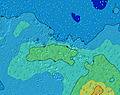  |    | ||||||||||||||||||||
SSW 16 | SSW 16 | SSW 16 | SSW 16 | SSW 15 | SSW 15 | S 14 | S 14 | SSW 14 | SSW 14 | SSW 14 | SSW 14 | SSW 13 | S 16 | SSW 15 | SSW 15 | SSW 14 | SSW 14 | SSW 14 | SSW 14 | SSW 14 | SSW 14 | SSW 14 | SSW 15 | |
1650 | 1904 | 2075 | 2386 | 2206 | 1475 | 2643 | 2557 | 1374 | 2221 | 1621 | 1299 | 1058 | 1029 | 2306 | 2558 | 2420 | 2343 | 2352 | 1970 | 1970 | 1610 | 1859 | 1948 | |
Vento (km/h) | ||||||||||||||||||||||||
Stato del vento onshore cross-onshore cross-shore cross-offshore offshore piatto | cross-on | cross-on | cross-on | cross-on | cross-on | cross-on | cross-on | cross-on | cross-on | cross-on | cross-on | cross-on | cross-on | cross-on | cross-on | cross | cross | cross | cross-off | cross-off | cross-off | off | off | off |
Alta Marea | 12:17PM0.37m | 1:00AM0.33m | 12:56PM0.36m | 1:40AM0.30m | 1:38PM0.33m | 2:22AM0.27m | ||||||||||||||||||
Basso Marea | 6:49PM-0.01m | 6:55AM0.07m | 7:32PM0.01m | 7:33AM0.08m | 8:19PM0.05m | |||||||||||||||||||
— | — | — | — | — | — | 6:16 | — | — | — | — | — | — | — | 6:16 | — | — | — | — | — | — | — | 6:16 | — | |
— | — | 5:31 | — | — | — | — | — | — | — | 5:30 | — | — | — | — | — | — | — | 5:30 | — | — | — | — | 5:30 | |
1 | — | — | — | — | — | — | — | — | — | — | — | — | — | — | — | — | — | 1 | 2 | 2 | 1 | — | — | |
Temp. °C | 25 | 25 | 25 | 25 | 25 | 25 | 25 | 25 | 25 | 25 | 25 | 25 | 25 | 25 | 25 | 26 | 26 | 27 | 27 | 26 | 27 | 28 | 28 | 28 |
23 | 23 | 23 | 22 | 22 | 22 | 23 | 22 | 22 | 22 | 22 | 21 | 21 | 22 | 22 | 23 | 23 | 25 | 25 | 25 | 26 | 27 | 26 | 29 | |
Onda 1 Altezza (m) Direzione Periodo (s) | SSW 16 | SSW 16 | SSW 16 | SSW 16 | SSW 15 | SSW 15 | S 14 | S 14 | SSW 14 | SSW 14 | SSW 14 | SSW 14 | SSW 13 | SSW 13 | SSW 15 | SSW 15 | SSW 14 | SSW 14 | SSW 14 | SSW 14 | SSW 14 | SSW 14 | SSW 14 | SSW 15 |
1650 | 1904 | 2075 | 2386 | 2206 | 1475 | 2643 | 2557 | 1374 | 2221 | 1621 | 1299 | 1058 | 892 | 2306 | 2558 | 2420 | 2343 | 2352 | 1970 | 1970 | 1610 | 1859 | 1948 | |
Onda 2 Altezza (m) Direzione Periodo (s) | SE 12 | SE 12 | SE 12 | SE 12 | SE 12 | SE 12 | SE 12 | SE 12 | SSW 8 | SE 12 | SSW 22 | S 18 | S 17 | S 16 | SSW 13 | SE 11 | SE 11 | SSW 19 | SE 11 | NW 13 | NW 13 | ESE 7 | ESE 7 | ESE 7 |
430 | 386 | 374 | 324 | 277 | 277 | 277 | 200 | 116 | 137 | 47 | 227 | 586 | 1029 | 101 | 75 | 75 | 248 | 40 | 7 | 7 | 349 | 292 | 199 | |
Onda 3 Altezza (m) Direzione Periodo (s) | NW 18 | ESE 8 | NW 17 | NNW 16 | NNW 16 | NW 16 | NW 16 | NW 16 | SE 12 | SSW 22 | NNW 15 | SSW 22 | SSW 21 | SE 11 | SE 11 | NNW 14 | NNW 13 | SE 11 | NNW 13 | NW 13 | — | SSW 17 | NW 12 | SE 10 |
12 | 14 | 11 | 26 | 26 | 10 | 10 | 10 | 197 | 45 | 21 | 47 | 42 | 76 | 59 | 18 | 18 | 43 | 18 | 7 | — | 475 | 6 | 16 | |
onde vento Altezza (m) Direzione Periodo (s) | S 5 | SSE 6 | SSE 6 | SE 6 | SE 6 | S 9 | — | SE 6 | SE 6 | ESE 6 | SE 7 | SE 7 | SE 7 | SE 7 | SE 7 | SE 7 | SE 7 | ESE 7 | ESE 7 | ESE 8 | ESE 7 | E 7 | — | N 4 |
99 | 140 | 161 | 120 | 103 | 463 | — | 148 | 178 | 111 | 347 | 408 | 420 | 357 | 314 | 268 | 286 | 345 | 376 | 447 | 417 | 387 | — | 9 | |
Il più vicino Offshore or Glassy | ||||||||||||||||||||||||
Distanza (km) | 2286 | 2286 | 2479 | 3512 | 3512 | 2479 | 3472 | 3512 | 2589 | 2513 | 2434 | 2310 | 2389 | 2482 | 2414 | 2286 | 1148 | 2287 | 2300 | 248 | 2286 | 1148 | 1148 | 1146 |
Migliori previsioni per le condizioni d'onda in Tahiti | ||||||||||||||||||||||||
Migliori previsioni per le condizioni d'onda in French Polynesia | ||||||||||||||||||||||||
Header Global | ||||||||||||||||||||||||
- Map Icons:
 Break
Break Live Wave Height (m)
 Live Wind Speed (km/h)
 Surf Rating (10 Max)
 Ocean Swells (m)
- Wind Speed (km/h)
Widget Free Surf-Forecast.com per il tuo sito
La relazione di surf / widget meteo è disponibile qui sotto per incorporare su siti esterni a titolo gratuito e fornisce una sintesi delle nostre Papara Beach previsione surf. Basta prendere il frammento di codice html da noi fornito e copiarlo nel proprio sito. È possibile scegliere la lingua preferita e unità metriche / imperiali per il feed delle previsioni surf per soddisfare le esigenze degli utenti del vostro sito .... Clicca qui per ottenere il codice.
 Nearest