

- Forecast
- Maps
- Live
- Weather State
- Spot Information
Ile d'Oleron - Passe du Trillou Surf Forecast
/ Charente Maritime (28 surf breaks) /
Ile d'Oleron - Passe du Trillou surf Forecast / Charente Maritime / France
- Map Icons:
 Break
Break Live Wave Height (m)
 Live Wind Speed (km/h)
 Surf Rating (10 Max)
 Ocean Swells (m)
- Wind Speed (km/h)
How big are the waves at Ile d'Oleron - Passe du Trillou today?
The current surf forecast for Ile d'Oleron - Passe du Trillou at 11PM is: 1.1m 11s primary swell from a West-northwest direction and 0.6m 6s secondary swell from a Southwest direction (forecast issued at 07:00pm April 26). The wind direction is predicted to be glassy and the swell rating is 3.
| Time (CEST) & Date | Wave Height | Wave Period |
|---|---|---|
| Morning (26 Apr) | - | - |
| Afternoon (26 Apr) | 1ft (0.3m) | 8s |
| Evening (26 Apr) | 2ft (0.6m) | 6s |
Table - waves today at Ile d'Oleron - Passe du Trillou. (Swell directed towards the surf break)
Friday 26 | Saturday 27 | Sunday 28 | Monday 29 | Tuesday 30 | Wednesday 01 | Thursday 02 | Friday 03 | Sat 04 | ||||||||||||||||||||||||||||||||||||||||||||||||||||
| 5 PM | 8 PM | 11 PM | 2 AM | 5 AM | 8 AM | 11 AM | 2 PM | 5 PM | 8 PM | 11 PM | 2 AM | 5 AM | 8 AM | 11 AM | 2 PM | 5 PM | 8 PM | 11 PM | 2 AM | 5 AM | 8 AM | 11 AM | 2 PM | 5 PM | 8 PM | 11 PM | 2 AM | 5 AM | 8 AM | 11 AM | 2 PM | 5 PM | 8 PM | 11 PM | 2 AM | 5 AM | 8 AM | 11 AM | 2 PM | 5 PM | 8 PM | 11 PM | 2 AM | 5 AM | 8 AM | 11 AM | 2 PM | 5 PM | 8 PM | 11 PM | 2 AM | 5 AM | 8 AM | 11 AM | 2 PM | 5 PM | 8 PM | 11 PM | 2 AM | |
Rating (10 max) | ||||||||||||||||||||||||||||||||||||||||||||||||||||||||||||
Swell Height Map |   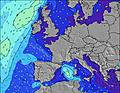 |    |    |   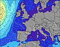 |  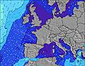 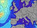 |  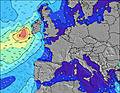 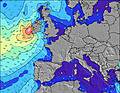 |  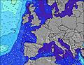 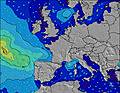 |  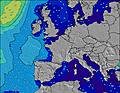 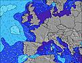 | 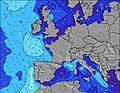 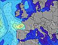 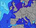 | |||||||||||||||||||||||||||||||||||||||||||||||||||
| Wave Height (m) & direction (?) | ||||||||||||||||||||||||||||||||||||||||||||||||||||||||||||
| Period(s) (?) | 8 | 6 | 11 | 10 | 10 | 10 | 10 | 6 | 13 | 13 | 12 | 12 | 12 | 11 | 11 | 11 | 11 | 7 | 10 | 10 | 10 | 10 | 9 | 7 | 9 | 13 | 9 | 13 | 12 | 12 | 12 | 8 | 8 | 8 | 8 | 8 | 8 | 8 | 7 | 9 | 9 | 10 | 10 | 10 | 10 | 10 | 10 | 12 | 11 | 11 | 10 | 10 | 10 | 9 | 9 | 9 | 9 | 9 | 9 | 9 |
Wave (?)Graph | ||||||||||||||||||||||||||||||||||||||||||||||||||||||||||||
| Energy (?) | 11 | 27 | 297 | 450 | 468 | 363 | 314 | 233 | 350 | 931 | 1068 | 361 | 355 | 343 | 249 | 167 | 136 | 121 | 109 | 109 | 54 | 117 | 116 | 42 | 90 | 55 | 61 | 52 | 46 | 45 | 69 | 87 | 121 | 115 | 138 | 208 | 164 | 111 | 82 | 189 | 235 | 313 | 449 | 510 | 510 | 440 | 377 | 736 | 629 | 778 | 363 | 426 | 356 | 276 | 235 | 194 | 162 | 129 | 151 | 129 |
Wind (km/h) | ||||||||||||||||||||||||||||||||||||||||||||||||||||||||||||
| Wind State (?) onshore cross-onshore cross-shore cross-offshore offshore glassy | on | cross- on | glass | cross- off | cross- off | cross- off | cross | cross- on | cross- on | cross- on | on | on | cross- on | on | cross- on | cross- on | cross- on | on | cross- on | cross- on | cross- on | glass | glass | on | cross- on | cross- on | glass | glass | cross | cross | cross- on | cross- on | on | off | cross- off | cross | cross- on | cross- on | on | cross- on | on | cross- on | on | cross- on | glass | glass | on | on | on | cross- on | cross- on | cross- on | cross- off | cross- off | cross- off | cross- off | cross- off | cross- off | cross- off | cross- off |
High Tide / height (m) | 6:36PM 4.23 | 6:51AM 4.07 | 7:04PM 4.12 | 7:22AM 3.90 | 7:38PM 3.94 | 8:00AM 3.67 | 8:20PM 3.73 | 8:49AM 3.40 | 9:20PM 3.49 | 10:19AM 3.15 | 11:45PM 3.37 | 1:11PM 3.27 | 1:32AM 3.62 | 2:17PM 3.58 | ||||||||||||||||||||||||||||||||||||||||||||||
Low Tide / height (m) | 1:21AM 0.36 | 1:39PM 0.52 | 2:02AM 0.54 | 2:20PM 0.72 | 2:47AM 0.75 | 3:08PM 0.95 | 3:40AM 0.95 | 4:05PM 1.14 | 4:43AM 1.08 | 5:11PM 1.24 | 5:55AM 1.07 | 6:23PM 1.17 | 7:07AM 0.87 | 7:33PM 0.94 | ||||||||||||||||||||||||||||||||||||||||||||||
Friday 26 | Saturday 27 | Sunday 28 | Monday 29 | Tuesday 30 | Wednesday 01 | Thursday 02 | Friday 03 | Sat 04 | ||||||||||||||||||||||||||||||||||||||||||||||||||||
| Sunrise | - | - | - | - | - | 6:58 | - | - | - | - | - | - | - | 6:56 | - | - | - | - | - | - | - | 6:54 | - | - | - | - | - | - | - | 6:52 | - | - | - | - | - | - | - | 6:50 | - | - | - | - | - | - | - | 6:50 | - | - | - | - | - | - | - | 6:48 | - | - | - | - | - | - |
| Sunset | - | 9:06 | - | - | - | - | - | - | - | 9:07 | - | - | - | - | - | - | - | 9:08 | - | - | - | - | - | - | - | 9:09 | - | - | - | - | - | - | - | 9:10 | - | - | - | - | - | - | - | 9:13 | - | - | - | - | - | - | - | 9:14 | - | - | - | - | - | - | - | 9:15 | - | - |
Rain (mm) | 1 | - | - | - | - | 1 | 1 | 1 | 1 | - | - | - | 1 | 1 | 1 | - | - | - | - | - | - | - | - | - | - | - | - | - | - | - | - | - | - | - | - | - | 1 | 1 | 1 | 2 | 1 | 1 | - | - | - | - | - | - | - | - | - | - | - | - | - | - | - | - | - | - |
| Temp. °C | 12 | 12 | 12 | 11 | 11 | 11 | 13 | 14 | 13 | 11 | 12 | 12 | 12 | 12 | 12 | 13 | 13 | 13 | 12 | 12 | 12 | 12 | 12 | 12 | 12 | 13 | 13 | 12 | 12 | 12 | 12 | 13 | 13 | 13 | 14 | 14 | 11 | 11 | 12 | 11 | 12 | 12 | 12 | 12 | 12 | 12 | 12 | 13 | 13 | 13 | 13 | 12 | 11 | 9 | 12 | 16 | 18 | 18 | 16 | 15 |
| Feels °C (?) | 9 | 9 | 11 | 8 | 5 | 4 | 7 | 5 | 4 | 2 | 4 | 6 | 5 | 6 | 6 | 7 | 8 | 9 | 8 | 9 | 9 | 11 | 10 | 10 | 9 | 11 | 11 | 11 | 10 | 9 | 8 | 9 | 11 | 11 | 12 | 11 | 5 | 6 | 8 | 6 | 7 | 8 | 9 | 10 | 11 | 11 | 9 | 9 | 8 | 8 | 10 | 10 | 7 | 3 | 5 | 10 | 13 | 13 | 10 | 9 |
FREE! Surf-Forecast.com widget for your website
The surf report / weather widget below is available to embed on third party websites free of charge and provides a summary of our Ile d'Oleron - Passe du Trillou surf forecast. Simply grab the html code snippet that we provide and paste it into your own site. You can choose your preferred language and metric/imperial units for the surf forecast feed to suit users of your site. Click here to get the code.


 Nearest