
Ranganunu Harbour Surf Guide
Ranganunu Harbour in Northland is a fairly exposed beach break that has fairly consistent surf Works best in offshore winds from the south. Groundswells more frequent than windswells and the ideal swell direction is from the northeast. The beach breaks offer lefts and rights. Best around mid tide when the tide is rising. Unlikely to be too crowded, even when the surf is up. Watch out for dangerous rips.
Ranganunu Harbour Spot Info
| Type: | Rating: | Reliability: | Todays Sea Temp*: |
|---|---|---|---|
| fairly consistent | 16.1°C*ocean temperature recorded from satellite |
Surfing Ranganunu Harbour:
The best conditions reported for surf at Ranganunu Harbour occur when a Northeast swell combines with an offshore wind direction from the South.

Previsioni Energia d'onda (Potenza): 12hrs


Ranganunu Harbour Surf:
Friday, 17 July 2026, 23:00 Local time| Ven | Sabato 18 | |||
| 9PM | 0AM | 3AM | 6AM | |
| Wave (m) | ||||
| Periodo (s) | 16 | 16 | 16 | 16 |
| Vento (km/h) | ||||
| Stato del vento | off | cross- off |
off | cross- off |
- /breaks/Ranganunu-Harbour/forecasts/latest
Ranganunu Harbour Surf Guide
Ranganunu Harbour in Northland is a fairly exposed beach break that has fairly consistent surf Works best in offshore winds from the south. Groundswells more frequent than windswells and the ideal swell direction is from the northeast. The beach breaks offer lefts and rights. Best around mid tide when the tide is rising. Unlikely to be too crowded, even when the surf is up. Watch out for dangerous rips.
Ranganunu Harbour Spot Info
Type: Rating: Reliability: Todays Sea Temp*:  Beach
Beach 2
2fairly consistent 16.1°C*ocean temperature recorded from satelliteSurfing Ranganunu Harbour:
The best conditions reported for surf at Ranganunu Harbour occur when a Northeast swell combines with an offshore wind direction from the South.
Previsioni Energia d'onda (Potenza): 12hrs
Utilizzare la scheda di navigazione in alto per visualizzare Ranganunu Harbour temperatura del mare, Ranganunu Harbour fotografie, Ranganunu Harbour dettagliate previsioni onde, il vento e le previsioni meteo, Ranganunu Harbour webcam, vento corrente da Northland stazioni meteo e Ranganunu Harbour previsioni marea. Il link New Zealand mappe maree apre l'immagine grande, che mostra New Zealand e dei mari circostanti. Queste mappe possono essere animate per mostrare le diverse componenti del moto ondoso, energia delle onde, periodo d'onda, altezza delle onde, insieme con le previsioni del vento e meteo, meteo corrente e osservazioni sullo stato del mare dal New Zealand onda-boe, le navi passanti e stazioni meteo costiere. Ciascuna delle pagine di previsioni per questo surf break rappresenta uno strumento di wavefinder globale e regionale per individuare le migliori condizioni di surf nella zona intorno Ranganunu Harbour.
Ranganunu Harbour Surf:
Friday, 17 July 2026, 23:00 Local timeVen Sabato 18 9PM 0AM 3AM 6AM Wave (m) Periodo (s) 16 16 16 16 Vento (km/h) Stato del vento off cross-
offoff cross-
off- /breaks/Ranganunu-Harbour/forecasts/latest
- /breaks/Ranganunu-Harbour/forecasts/latest/six_day
Ranganunu Harbour Surf Guide
Ranganunu Harbour in Northland is a fairly exposed beach break that has fairly consistent surf Works best in offshore winds from the south. Groundswells more frequent than windswells and the ideal swell direction is from the northeast. The beach breaks offer lefts and rights. Best around mid tide when the tide is rising. Unlikely to be too crowded, even when the surf is up. Watch out for dangerous rips.
Ranganunu Harbour Spot Info
Type: Rating: Reliability: Todays Sea Temp*: Beach2fairly consistent 16.1°C*ocean temperature recorded from satelliteSurfing Ranganunu Harbour:
The best conditions reported for surf at Ranganunu Harbour occur when a Northeast swell combines with an offshore wind direction from the South.
Previsioni Energia d'onda (Potenza): 12hrs
Utilizzare la scheda di navigazione in alto per visualizzare Ranganunu Harbour temperatura del mare, Ranganunu Harbour fotografie, Ranganunu Harbour dettagliate previsioni onde, il vento e le previsioni meteo, Ranganunu Harbour webcam, vento corrente da Northland stazioni meteo e Ranganunu Harbour previsioni marea. Il link New Zealand mappe maree apre l'immagine grande, che mostra New Zealand e dei mari circostanti. Queste mappe possono essere animate per mostrare le diverse componenti del moto ondoso, energia delle onde, periodo d'onda, altezza delle onde, insieme con le previsioni del vento e meteo, meteo corrente e osservazioni sullo stato del mare dal New Zealand onda-boe, le navi passanti e stazioni meteo costiere. Ciascuna delle pagine di previsioni per questo surf break rappresenta uno strumento di wavefinder globale e regionale per individuare le migliori condizioni di surf nella zona intorno Ranganunu Harbour.
Ranganunu Harbour Surf:
Friday, 17 July 2026, 23:00 Local timeVen Sabato 18 9PM 0AM 3AM 6AM Wave (m) Periodo (s) 16 16 16 16 Vento (km/h) Stato del vento off cross-
offoff cross-
off- /breaks/Ranganunu-Harbour/forecasts/latest
Ranganunu Harbour Surf Guide
Ranganunu Harbour in Northland is a fairly exposed beach break that has fairly consistent surf Works best in offshore winds from the south. Groundswells more frequent than windswells and the ideal swell direction is from the northeast. The beach breaks offer lefts and rights. Best around mid tide when the tide is rising. Unlikely to be too crowded, even when the surf is up. Watch out for dangerous rips.
Ranganunu Harbour Spot Info
Type: Rating: Reliability: Todays Sea Temp*: Beach2fairly consistent 16.1°C*ocean temperature recorded from satelliteSurfing Ranganunu Harbour:
The best conditions reported for surf at Ranganunu Harbour occur when a Northeast swell combines with an offshore wind direction from the South.
Previsioni Energia d'onda (Potenza): 12hrs
Utilizzare la scheda di navigazione in alto per visualizzare Ranganunu Harbour temperatura del mare, Ranganunu Harbour fotografie, Ranganunu Harbour dettagliate previsioni onde, il vento e le previsioni meteo, Ranganunu Harbour webcam, vento corrente da Northland stazioni meteo e Ranganunu Harbour previsioni marea. Il link New Zealand mappe maree apre l'immagine grande, che mostra New Zealand e dei mari circostanti. Queste mappe possono essere animate per mostrare le diverse componenti del moto ondoso, energia delle onde, periodo d'onda, altezza delle onde, insieme con le previsioni del vento e meteo, meteo corrente e osservazioni sullo stato del mare dal New Zealand onda-boe, le navi passanti e stazioni meteo costiere. Ciascuna delle pagine di previsioni per questo surf break rappresenta uno strumento di wavefinder globale e regionale per individuare le migliori condizioni di surf nella zona intorno Ranganunu Harbour.
Ranganunu Harbour Surf:
Friday, 17 July 2026, 23:00 Local timeVen Sabato 18 9PM 0AM 3AM 6AM Wave (m) Periodo (s) 16 16 16 16 Vento (km/h) Stato del vento off cross-
offoff cross-
offTide Times:
Per Sheigis Beacon, New Zealand, %{dist} %{km} da %{location}.
PROSSIMA È ALLE (ora locale) rimanente alta marea bassa marea Ranganunu Harbour Tide Times and Tide Chart
Live Weather:
At Tokerau Beach wx, 12 km from Ranganunu Harbour.
calm
(km/h)
dryAir temperature
11°COverall Ranganunu Harbour Surf Consistency and Wind Distribution in Luglio
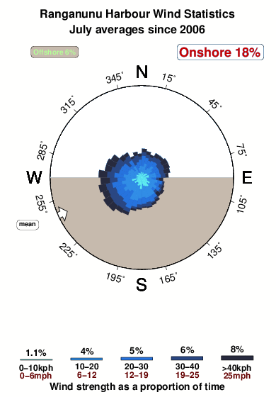


Wind stats for Ranganunu Harbour: see the variation in direction and stength by month.
foto dall' album
Contorni: Strade e fiumi: seleziona un surf break dal menu 


Utilizzare questa mappa sollievo per navigare Northland surf breaks e stazioni di marea che si trovano nella zona diRanganunu Harbour
Altri surf breaks più vicini al Ranganunu Harbour:
(clicca sul nome del luogo per maggiori informazioni)- Closest località surf3 mi
- Second closest località surf5 mi
- Third closest località surf6 mi
- Fourth closest località surf7 mi
- Fifth closest località surf9 mi
Onda boe più vicina a Ranganunu Harbour:
- Closest Onda boa101 mi
- Second closest Onda boa270 mi
- Third closest Onda boa401 mi
- Fourth closest Onda boa441 mi
- Fifth closest Onda boa441 mi
Stazioni di marea più vicina alla Ranganunu Harbour:
- Closest marea stazioneSheigis Beacon4 mi
- Second closest marea stazioneHouhora River Entrance6 mi
- Third closest marea stazioneHouhora Harbour (Pukenui Wharf)7 mi
- Fourth closest marea stazioneOmaia Island8 mi
- Fifth closest marea stazioneDairy Factory Wharf12 mi
Airports
- The closest passenger airport to Ranganunu Harbour is Kaitaia Airport (KAT) in New Zealand, which is 21 km (13 miles) away (directly).
- The second nearest airport to Ranganunu Harbour is Kerikeri Airport (KKE), also in New Zealand, 74 km (46 miles) away.
- The third closest airport is Whangarei Airport (WRE), also in New Zealand, 142 km (88 miles) away.

- /breaks/Ranganunu-Harbour/forecasts/latest


 Nearest