- Forecast
- Maps
- Live
- Weather State
- Spot Information
Previsioni:


Surf a SalailuaPrevisione / Savaii / Samoa
Aggiornamento meteo in hr min s Forecast update imminent
Questi sono altezze d'onde di mare aperto. Onde che si infrangono di solito sono più piccole, specialmente in luoghi riparati.
La temperatura del mare a Salailua oggi è
30.0° C
(Che è leggermente più caldo del solito)Aggiornamento in hr min s Forecast update imminent
Sabato 18 | Domenica 19 | Lunedì 20 | Mar 21 | |||||||||||||||||||||
| 4 AM | 7 AM | 10 AM | 1 PM | 4 PM | 7 PM | 10 PM | 1 AM | 4 AM | 7 AM | 10 AM | 1 PM | 4 PM | 7 PM | 10 PM | 1 AM | 4 AM | 7 AM | 10 AM | 1 PM | 4 PM | 7 PM | 10 PM | 1 AM | |
Voto (10 max) | ||||||||||||||||||||||||
Mappa dell'altezza del moto ondoso |  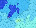  | 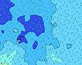  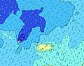 |  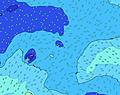 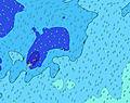 |  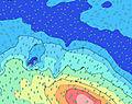 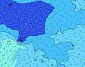 | ||||||||||||||||||||
| Le onde più grandi (m) & direzione (?) | ||||||||||||||||||||||||
| Periodo(s) (?) | 13 | 13 | 13 | 13 | 13 | 12 | 12 | 12 | 12 | 12 | 12 | 12 | 12 | 12 | 11 | 11 | 15 | 15 | 14 | 11 | 13 | 13 | 13 | 13 |
Grafico (?)delle onde | ||||||||||||||||||||||||
| 369 | 326 | 321 | 321 | 405 | 341 | 336 | 347 | 341 | 384 | 378 | 319 | 289 | 235 | 211 | 151 | 151 | 149 | 203 | 191 | 412 | 406 | 331 | 336 | |
Vento (km/h) | ||||||||||||||||||||||||
| Stato del vento (?) onshore cross-onshore cross-shore cross-offshore offshore piatto | cross- on | cross | cross | cross | cross- off | cross- off | cross- off | cross- off | cross | cross | cross- off | cross- off | cross- off | cross- off | cross- off | cross- off | cross- off | cross- off | cross- off | cross- off | cross- off | cross- off | cross- off | cross- off |
Alta Marea / altezza (m) | 6:39AM 1.35 | 7:08PM 1.22 | 7:28AM 1.34 | 8:01PM 1.17 | 8:20AM 1.31 | 9:00PM 1.10 | ||||||||||||||||||
Basso Marea / altezza (m) | 12:59PM 0.01 | 1:11AM 0.08 | 1:51PM 0.02 | 2:01AM 0.12 | 2:47PM 0.06 | |||||||||||||||||||
Sabato 18 | Domenica 19 | Lunedì 20 | Mar 21 | |||||||||||||||||||||
| Alba | - | 6:37 | - | - | - | - | - | - | - | 6:37 | - | - | - | - | - | - | - | 6:37 | - | - | - | - | - | - |
| Tramonto | - | - | - | - | 6:22 | - | - | - | - | - | - | - | 6:22 | - | - | - | - | - | - | - | 6:21 | - | - | - |
Piog. (mm) | 1 | - | - | 1 | - | 1 | 2 | 1 | - | - | 1 | 1 | - | 1 | 2 | 2 | 1 | - | 2 | 1 | 1 | 1 | 1 | 1 |
| Temp. °C | 28 | 28 | 28 | 28 | 28 | 28 | 28 | 28 | 28 | 28 | 28 | 28 | 29 | 28 | 29 | 28 | 28 | 28 | 29 | 29 | 29 | 29 | 29 | 29 |
| Feels °C (?) | 31 | 32 | 32 | 31 | 31 | 31 | 31 | 30 | 30 | 30 | 29 | 29 | 31 | 30 | 31 | 30 | 30 | 30 | 31 | 31 | 31 | 31 | 30 | 30 |
- Map Icons:
 Break
Break Live Wave Height (m)
 Live Wind Speed (km/h)
 Surf Rating (10 Max)
 Ocean Swells (m)
- Wind Speed (km/h)
Widget Free Surf-Forecast.com per il tuo sito
La relazione di surf / widget meteo è disponibile qui sotto per incorporare su siti esterni a titolo gratuito e fornisce una sintesi delle nostre Salailua previsione surf. Basta prendere il frammento di codice html da noi fornito e copiarlo nel proprio sito. È possibile scegliere la lingua preferita e unità metriche / imperiali per il feed delle previsioni surf per soddisfare le esigenze degli utenti del vostro sito .... Clicca qui per ottenere il codice.
 Nearest