- Forecast
- Maps
- Live
- Weather State
- Spot Information
Souillac Previsione surf
/ Mauritius (25 surf breaks) /Previsioni:

Surf a SouillacPrevisione / Mauritius / Mauritius
Aggiornamento meteo in hr min s Forecast update imminent
Questi sono altezze d'onde di mare aperto. Onde che si infrangono di solito sono più piccole, specialmente in luoghi riparati.
La temperatura del mare a Souillac oggi è
26.8° C
(Che è 1.1°C più caldo del normale per questo periodo dell'anno)Aggiornamento in hr min s Forecast update imminent
Previsione a breve termineper lo più asciutto. Warm (Max 26°C Lunedì mattina, Min 24°C Lunedì notte). Vento sarà generalmente leggero. | ||||||||||||||||||||||||
Monday 18 | Tuesday 19 | Wednesday 20 | ||||||||||||||||||||||
1 AM | 4 AM | 7 AM | 10 AM | 1 PM | 4 PM | 7 PM | 10 PM | 1 AM | 4 AM | 7 AM | 10 AM | 1 PM | 4 PM | 7 PM | 10 PM | 1 AM | 4 AM | 7 AM | 10 AM | 1 PM | 4 PM | 7 PM | 10 PM | |
Mappa dell'altezza del moto ondoso |  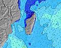 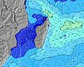 | 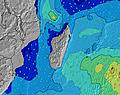 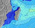 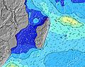 | 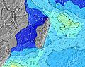 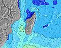 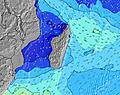 | |||||||||||||||||||||
SW 14 | SW 14 | SW 14 | SW 14 | SW 14 | SW 13 | ESE 12 | ESE 11 | ESE 12 | ESE 12 | ESE 12 | ESE 12 | ESE 11 | SSW 15 | ESE 11 | SSW 14 | ESE 11 | ESE 11 | SSW 13 | SSW 13 | ESE 10 | ESE 10 | SSW 12 | SSW 12 | |
2032 | 1836 | 1688 | 1537 | 1255 | 1200 | 1029 | 1111 | 1102 | 1121 | 1121 | 1102 | 1045 | 1275 | 1032 | 933 | 920 | 822 | 791 | 710 | 598 | 502 | 439 | 373 | |
Vento (km/h) | ||||||||||||||||||||||||
Stato del vento onshore cross-onshore cross-shore cross-offshore offshore piatto | cross | cross | cross | cross | cross | cross | cross | cross | cross | cross | cross | cross | cross | cross-on | cross | cross-on | cross-on | cross-on | cross-on | cross-on | cross-on | cross-on | cross-on | cross-on |
Alta Marea | 1:00AM0.85m | 1:48PM0.71m | 1:39AM0.82m | 2:35PM0.65m | 2:19AM0.76m | 3:26PM0.59m | ||||||||||||||||||
Basso Marea | 7:35AM-0.02m | 7:33PM0.17m | 8:19AM0.01m | 8:13PM0.22m | 9:07AM0.07m | 8:57PM0.28m | ||||||||||||||||||
— | 6:31 | — | — | — | — | — | — | — | 6:33 | — | — | — | — | — | — | — | 6:33 | — | — | — | — | — | — | |
— | — | — | — | — | 5:38 | — | — | — | — | — | — | — | 5:38 | — | — | — | — | — | — | — | 5:38 | — | — | |
— | — | — | — | — | — | — | — | — | — | — | — | — | — | — | — | — | — | — | — | — | — | — | — | |
Temp. °C | 24 | 23 | 24 | 25 | 26 | 25 | 25 | 24 | 24 | 24 | 24 | 25 | 25 | 25 | 24 | 24 | 24 | 25 | 24 | 25 | 25 | 25 | 24 | 24 |
24 | 24 | 24 | 26 | 26 | 26 | 26 | 24 | 24 | 24 | 24 | 25 | 25 | 25 | 24 | 25 | 25 | 26 | 25 | 26 | 26 | 26 | 24 | 25 | |
Onda 1 Altezza (m) Direzione Periodo (s) | SW 14 | SW 14 | SW 14 | SW 14 | SW 14 | SW 13 | SW 13 | ESE 11 | ESE 12 | SW 13 | ESE 12 | SW 12 | ESE 11 | ESE 11 | ESE 11 | SSW 14 | SSW 13 | SSW 13 | SSW 13 | ESE 10 | ESE 10 | ESE 10 | E 10 | E 10 |
2032 | 1836 | 1688 | 1537 | 1255 | 1200 | 1011 | 1111 | 1102 | 679 | 1121 | 449 | 1045 | 1008 | 1016 | 933 | 905 | 781 | 732 | 676 | 598 | 502 | 332 | 284 | |
Onda 2 Altezza (m) Direzione Periodo (s) | ESE 9 | ESE 9 | E 11 | E 11 | E 13 | E 12 | S 19 | SW 13 | SW 13 | S 17 | SW 13 | S 16 | SW 12 | SSW 15 | SSW 14 | SW 15 | SW 15 | SW 14 | SW 14 | SSW 13 | SSW 12 | SSW 12 | SSW 12 | SSW 12 |
543 | 501 | 58 | 82 | 316 | 423 | 7 | 841 | 841 | 217 | 594 | 516 | 435 | 1275 | 1032 | 106 | 136 | 169 | 167 | 710 | 558 | 447 | 439 | 373 | |
Onda 3 Altezza (m) Direzione Periodo (s) | — | E 12 | — | E 13 | — | — | — | S 18 | SSW 18 | SW 16 | SSW 16 | SW 16 | S 15 | SW 15 | SW 15 | SW 15 | SW 15 | SW 15 | W 20 | SW 14 | SW 14 | SW 13 | SW 13 | SW 13 |
— | 27 | — | 87 | — | — | — | 27 | 106 | 67 | 350 | 157 | 544 | 113 | 107 | 136 | 136 | 171 | 7 | 160 | 153 | 173 | 171 | 140 | |
onde vento Altezza (m) Direzione Periodo (s) | — | — | ESE 9 | ESE 11 | ESE 11 | SE 10 | ESE 12 | — | — | ESE 12 | — | ESE 12 | — | — | — | ESE 11 | ESE 11 | ESE 11 | ESE 10 | — | — | — | SSE 7 | SSE 7 |
— | — | 431 | 513 | 513 | 416 | 1029 | — | — | 1121 | — | 1102 | — | — | — | 908 | 920 | 822 | 791 | — | — | — | 78 | 78 | |
Il più vicino Offshore or Glassy | ||||||||||||||||||||||||
Distanza (km) | 23 | 1 | 23 | 23 | 49 | 16 | 24 | 24 | 24 | 24 | 24 | 24 | 49 | 16 | 49 | 16 | 16 | 16 | 16 | 16 | 16 | 16 | 16 | 16 |
Migliori previsioni per le condizioni d'onda in Mauritius | ||||||||||||||||||||||||
Migliori previsioni per le condizioni d'onda in Mauritius | ||||||||||||||||||||||||
Header Global | ||||||||||||||||||||||||
- Map Icons:
 Break
Break Live Wave Height (m)
 Live Wind Speed (km/h)
 Surf Rating (10 Max)
 Ocean Swells (m)
- Wind Speed (km/h)
Widget Free Surf-Forecast.com per il tuo sito
La relazione di surf / widget meteo è disponibile qui sotto per incorporare su siti esterni a titolo gratuito e fornisce una sintesi delle nostre Souillac previsione surf. Basta prendere il frammento di codice html da noi fornito e copiarlo nel proprio sito. È possibile scegliere la lingua preferita e unità metriche / imperiali per il feed delle previsioni surf per soddisfare le esigenze degli utenti del vostro sito .... Clicca qui per ottenere il codice.
 Nearest