- Forecast
- Maps
- Live
- Weather State
- Spot Information
Slip Point (Clallam Bay) Previsione surf
/ Washington (29 breaks) / Washington (29 breaks) /Previsioni:

Surf a Slip Point (Clallam Bay)Previsione / Washington / USA
Aggiornamento meteo in hr min s Forecast update imminent
Questi sono altezze d'onde di mare aperto. Onde che si infrangono di solito sono più piccole, specialmente in luoghi riparati.
La temperatura del mare a Slip Point (Clallam Bay) oggi è
10.4° C
(Che è 1.4°C più freddo della media per questo periodo dell'anno)Aggiornamento in hr min s Forecast update imminent
Previsione a breve termineper lo più asciutto. Very mild (Max 14°C Domenica mattina, Min 7°C Domenica mattina). Vento sarà generalmente leggero. | ||||||||||||||||||||||||
Sun 17 | Monday 18 | Tuesday 19 | Wed 20 | |||||||||||||||||||||
2 PM | 5 PM | 8 PM | 11 PM | 2 AM | 5 AM | 8 AM | 11 AM | 2 PM | 5 PM | 8 PM | 11 PM | 2 AM | 5 AM | 8 AM | 11 AM | 2 PM | 5 PM | 8 PM | 11 PM | 2 AM | 5 AM | 8 AM | 11 AM | |
Mappa dell'altezza del moto ondoso | 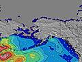 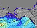 | 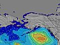 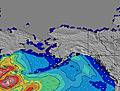 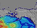 | 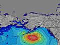 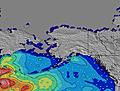 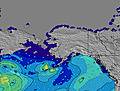 |    | ||||||||||||||||||||
W 11 | W 11 | W 10 | W 10 | W 10 | W 10 | W 10 | W 16 | W 16 | W 15 | W 14 | W 14 | W 14 | W 14 | W 13 | W 13 | W 13 | W 13 | W 13 | W 12 | W 12 | W 12 | W 12 | W 12 | |
0 | 0 | 0 | 0 | 0 | 94 | 70 | 0 | 0 | 0 | 0 | 0 | 0 | 831 | 771 | 663 | 0 | 0 | 0 | 0 | 0 | 0 | 464 | 390 | |
Vento (km/h) | ||||||||||||||||||||||||
Stato del vento onshore cross-onshore cross-shore cross-offshore offshore piatto | cross-on | on | cross-on | cross | cross | cross | cross | cross-on | cross-on | cross-on | cross-on | cross | cross-on | cross-on | glassy | cross-on | on | cross-on | cross-on | cross | cross | glassy | glassy | cross-off |
Alta Marea | 3:33PM3.91m | 1:37AM4.82m | 4:27PM3.92m | 2:23AM4.76m | 5:23PM3.91m | 3:14AM4.61m | ||||||||||||||||||
Basso Marea | 7:46PM3.27m | 9:34AM1.10m | 8:33PM3.35m | 10:22AM1.19m | 9:26PM3.41m | |||||||||||||||||||
— | — | — | — | — | 5:33 | — | — | — | — | — | — | — | 5:31 | — | — | — | — | — | — | — | 5:31 | — | — | |
— | — | 8:52 | — | — | — | — | — | — | — | 8:52 | — | — | — | — | — | — | — | 8:53 | — | — | — | — | 8:55 | |
— | — | — | — | — | — | — | — | — | — | — | — | — | — | — | — | — | — | — | — | — | — | — | — | |
Temp. °C | 13 | 14 | 11 | 8 | 8 | 7 | 9 | 11 | 13 | 13 | 12 | 9 | 10 | 10 | 11 | 12 | 14 | 13 | 11 | 9 | 8 | 8 | 10 | 13 |
10 | 10 | 8 | 5 | 5 | 4 | 7 | 8 | 9 | 10 | 10 | 7 | 8 | 9 | 10 | 11 | 11 | 9 | 9 | 7 | 6 | 7 | 9 | 11 | |
Onda 1 Altezza (m) Direzione Periodo (s) | W 11 | W 11 | W 10 | W 10 | W 6 | W 6 | W 6 | W 12 | W 16 | W 15 | W 14 | W 14 | W 14 | W 14 | W 13 | W 13 | W 13 | W 13 | W 13 | W 12 | W 12 | W 8 | W 12 | W 12 |
382 | 319 | 259 | 202 | 47 | 81 | 66 | 187 | 977 | 1037 | 1059 | 1030 | 1014 | 831 | 771 | 663 | 643 | 633 | 623 | 496 | 547 | 182 | 464 | 390 | |
Onda 2 Altezza (m) Direzione Periodo (s) | SW 14 | SW 14 | SW 14 | SW 14 | W 10 | W 10 | W 10 | W 6 | SSW 14 | SW 14 | SW 14 | SW 13 | SW 13 | SW 13 | SW 13 | SW 13 | SW 13 | SW 16 | SW 16 | SW 16 | SW 16 | W 12 | SW 16 | SW 16 |
33 | 33 | 32 | 32 | 125 | 94 | 70 | 36 | 19 | 7 | 7 | 7 | 7 | 7 | 7 | 7 | 7 | 43 | 41 | 41 | 41 | 177 | 42 | 41 | |
Onda 3 Altezza (m) Direzione Periodo (s) | — | — | W 21 | W 20 | SW 14 | W 18 | W 18 | W 16 | — | — | — | W 26 | W 26 | — | — | — | — | SW 24 | SW 24 | SW 24 | SW 24 | SW 16 | — | — |
— | — | 9 | 8 | 32 | 57 | 96 | 249 | — | — | — | 13 | 13 | — | — | — | — | 22 | 22 | 22 | 22 | 42 | — | — | |
onde vento Altezza (m) Direzione Periodo (s) | — | — | — | — | — | — | — | — | — | — | — | — | — | — | — | — | — | — | — | — | — | — | — | — |
— | — | — | — | — | — | — | — | — | — | — | — | — | — | — | — | — | — | — | — | — | — | — | — | |
Il più vicino Offshore or Glassy | ||||||||||||||||||||||||
Distanza (km) | 27 | 1270 | 1270 | 14 | 20 | 14 | 14 | 832 | 1270 | 244 | 244 | 14 | 14 | 14 | 0 | 14 | 74 | 1270 | 958 | 14 | 14 | 1 | 0 | 0 |
Migliori previsioni per le condizioni d'onda in Washington State | ||||||||||||||||||||||||
Migliori previsioni per le condizioni d'onda in United States | ||||||||||||||||||||||||
Header Global | ||||||||||||||||||||||||
- Map Icons:
 Break
Break Live Wave Height (m)
 Live Wind Speed (km/h)
 Surf Rating (10 Max)
 Ocean Swells (m)
- Wind Speed (km/h)
Widget Free Surf-Forecast.com per il tuo sito
La relazione di surf / widget meteo è disponibile qui sotto per incorporare su siti esterni a titolo gratuito e fornisce una sintesi delle nostre Slip Point (Clallam Bay) previsione surf. Basta prendere il frammento di codice html da noi fornito e copiarlo nel proprio sito. È possibile scegliere la lingua preferita e unità metriche / imperiali per il feed delle previsioni surf per soddisfare le esigenze degli utenti del vostro sito .... Clicca qui per ottenere il codice.
 Nearest