

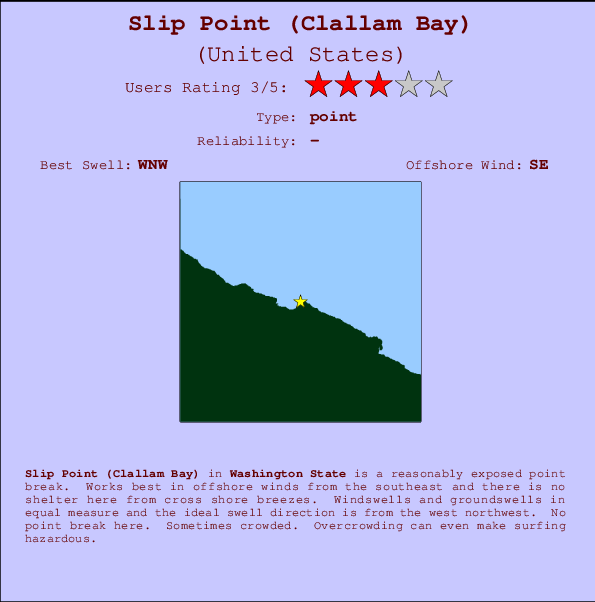
Slip Point (Clallam Bay) Surf Guide
Slip Point (Clallam Bay) in Washington State is a fairly exposed point break. The best wind direction is from the southeast and there is no shelter here from cross shore breezes. Most of the surf here comes from groundswells and the best swell direction is from the west northwest. There is no point break. When the surf is up, it can get quite busy in the water. Crowds may reach hazard levels at this break - consider wearing a lid.
Slip Point (Clallam Bay) Spot Info
| Type: | Rating: | Reliability: | Todays Sea Temp*: |
|---|---|---|---|
10.9°C*ocean temperature recorded from satellite |
Surfing Slip Point (Clallam Bay):
The best conditions reported for surf at Slip Point (Clallam Bay) occur when a West-northwest swell combines with an offshore wind direction from the Southeast.
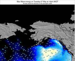
Previsioni Energia d'onda (Potenza): 12hrs
Slip Point (Clallam Bay) Surf:
Tuesday, 14 July 2026, 19:10 Local time| Mar | Mer | |||
| 8PM | 11PM | 2AM | 5AM | |
| Wave (m) | ||||
| Periodo (s) | - | - | - | - |
| Vento (km/h) | ||||
| Stato del vento | on | cross- on |
cross- on |
cross- on |
- /breaks/Slip-Point-Clallam-Bay/forecasts/latest
Slip Point (Clallam Bay) Surf Guide
Slip Point (Clallam Bay) in Washington State is a fairly exposed point break. The best wind direction is from the southeast and there is no shelter here from cross shore breezes. Most of the surf here comes from groundswells and the best swell direction is from the west northwest. There is no point break. When the surf is up, it can get quite busy in the water. Crowds may reach hazard levels at this break - consider wearing a lid.
Slip Point (Clallam Bay) Spot Info
Type: Rating: Reliability: Todays Sea Temp*:  Point
Point 310.9°C*ocean temperature recorded from satellite
Surfing Slip Point (Clallam Bay):
The best conditions reported for surf at Slip Point (Clallam Bay) occur when a West-northwest swell combines with an offshore wind direction from the Southeast.
Previsioni Energia d'onda (Potenza): 12hrs
Utilizzare la scheda di navigazione in alto per visualizzare Slip Point (Clallam Bay) temperatura del mare, Slip Point (Clallam Bay) fotografie, Slip Point (Clallam Bay) dettagliate previsioni onde, il vento e le previsioni meteo, Slip Point (Clallam Bay) webcam, vento corrente da Washington stazioni meteo e Slip Point (Clallam Bay) previsioni marea. Il link United States mappe maree apre l'immagine grande, che mostra United States e dei mari circostanti. Queste mappe possono essere animate per mostrare le diverse componenti del moto ondoso, energia delle onde, periodo d'onda, altezza delle onde, insieme con le previsioni del vento e meteo, meteo corrente e osservazioni sullo stato del mare dal United States onda-boe, le navi passanti e stazioni meteo costiere. Ciascuna delle pagine di previsioni per questo surf break rappresenta uno strumento di wavefinder globale e regionale per individuare le migliori condizioni di surf nella zona intorno Slip Point (Clallam Bay).
Slip Point (Clallam Bay) Surf:
Tuesday, 14 July 2026, 19:10 Local timeMar Mer 8PM 11PM 2AM 5AM Wave (m) Periodo (s) - - - - Vento (km/h) Stato del vento on cross-
oncross-
oncross-
on- /breaks/Slip-Point-Clallam-Bay/forecasts/latest
- /breaks/Slip-Point-Clallam-Bay/forecasts/latest/six_day
Slip Point (Clallam Bay) Surf Guide
Slip Point (Clallam Bay) in Washington State is a fairly exposed point break. The best wind direction is from the southeast and there is no shelter here from cross shore breezes. Most of the surf here comes from groundswells and the best swell direction is from the west northwest. There is no point break. When the surf is up, it can get quite busy in the water. Crowds may reach hazard levels at this break - consider wearing a lid.
Slip Point (Clallam Bay) Spot Info
Type: Rating: Reliability: Todays Sea Temp*: Point310.9°C*ocean temperature recorded from satelliteSurfing Slip Point (Clallam Bay):
The best conditions reported for surf at Slip Point (Clallam Bay) occur when a West-northwest swell combines with an offshore wind direction from the Southeast.
Previsioni Energia d'onda (Potenza): 12hrs
Utilizzare la scheda di navigazione in alto per visualizzare Slip Point (Clallam Bay) temperatura del mare, Slip Point (Clallam Bay) fotografie, Slip Point (Clallam Bay) dettagliate previsioni onde, il vento e le previsioni meteo, Slip Point (Clallam Bay) webcam, vento corrente da Washington stazioni meteo e Slip Point (Clallam Bay) previsioni marea. Il link United States mappe maree apre l'immagine grande, che mostra United States e dei mari circostanti. Queste mappe possono essere animate per mostrare le diverse componenti del moto ondoso, energia delle onde, periodo d'onda, altezza delle onde, insieme con le previsioni del vento e meteo, meteo corrente e osservazioni sullo stato del mare dal United States onda-boe, le navi passanti e stazioni meteo costiere. Ciascuna delle pagine di previsioni per questo surf break rappresenta uno strumento di wavefinder globale e regionale per individuare le migliori condizioni di surf nella zona intorno Slip Point (Clallam Bay).
Slip Point (Clallam Bay) Surf:
Tuesday, 14 July 2026, 19:10 Local timeMar Mer 8PM 11PM 2AM 5AM Wave (m) Periodo (s) - - - - Vento (km/h) Stato del vento on cross-
oncross-
oncross-
on- /breaks/Slip-Point-Clallam-Bay/forecasts/latest
Slip Point (Clallam Bay) Surf Guide
Slip Point (Clallam Bay) in Washington State is a fairly exposed point break. The best wind direction is from the southeast and there is no shelter here from cross shore breezes. Most of the surf here comes from groundswells and the best swell direction is from the west northwest. There is no point break. When the surf is up, it can get quite busy in the water. Crowds may reach hazard levels at this break - consider wearing a lid.
Slip Point (Clallam Bay) Spot Info
Type: Rating: Reliability: Todays Sea Temp*: Point310.9°C*ocean temperature recorded from satelliteSurfing Slip Point (Clallam Bay):
The best conditions reported for surf at Slip Point (Clallam Bay) occur when a West-northwest swell combines with an offshore wind direction from the Southeast.
Previsioni Energia d'onda (Potenza): 12hrs
Utilizzare la scheda di navigazione in alto per visualizzare Slip Point (Clallam Bay) temperatura del mare, Slip Point (Clallam Bay) fotografie, Slip Point (Clallam Bay) dettagliate previsioni onde, il vento e le previsioni meteo, Slip Point (Clallam Bay) webcam, vento corrente da Washington stazioni meteo e Slip Point (Clallam Bay) previsioni marea. Il link United States mappe maree apre l'immagine grande, che mostra United States e dei mari circostanti. Queste mappe possono essere animate per mostrare le diverse componenti del moto ondoso, energia delle onde, periodo d'onda, altezza delle onde, insieme con le previsioni del vento e meteo, meteo corrente e osservazioni sullo stato del mare dal United States onda-boe, le navi passanti e stazioni meteo costiere. Ciascuna delle pagine di previsioni per questo surf break rappresenta uno strumento di wavefinder globale e regionale per individuare le migliori condizioni di surf nella zona intorno Slip Point (Clallam Bay).
Slip Point (Clallam Bay) Surf:
Tuesday, 14 July 2026, 19:10 Local timeMar Mer 8PM 11PM 2AM 5AM Wave (m) Periodo (s) - - - - Vento (km/h) Stato del vento on cross-
oncross-
oncross-
onTide Times:
Per Sekiu, Washington, %{dist} %{km} da %{location}.
PROSSIMA È ALLE (ora locale) rimanente alta marea bassa marea Slip Point (Clallam Bay) Tide Times and Tide Chart
Live Weather:
At Sheringham Point- BC, 28 km from Slip Point (Clallam Bay).
calm
(km/h)Air temperature
-°CCurrent weather near Slip Point (Clallam Bay)
Buoy Data:
At Neah Bay Buoy, 27 miles from Slip Point (Clallam Bay).
1PM 2PM 3PM 4PM Attualità dei dati 5 hr 4 hr 3 hr 2 hr Altezza delle onde (m) 


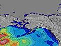
Overall Slip Point (Clallam Bay) Surf Consistency and Wind Distribution in Luglio


Wind stats for Slip Point (Clallam Bay): see the variation in direction and stength by month.
foto dall' album
Contorni: Strade e fiumi: seleziona un surf break dal menu 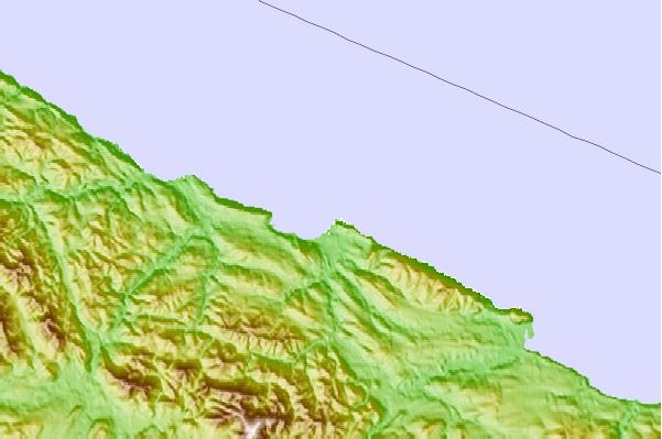

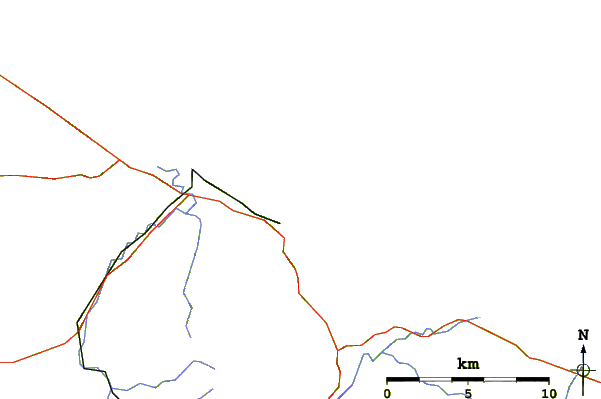
Utilizzare questa mappa sollievo per navigare Washington surf breaks e stazioni di marea che si trovano nella zona diSlip Point (Clallam Bay)
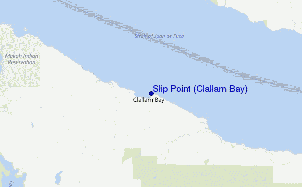
Altri surf breaks più vicini al Slip Point (Clallam Bay):
(clicca sul nome del luogo per maggiori informazioni)- Closest località surf1 mi
- Second closest località surf9 mi
- Third closest località surf11 mi
- Fourth closest località surf12 mi
- Fifth closest località surf14 mi
Onda boe più vicina a Slip Point (Clallam Bay):
- Closest Onda boa27 mi
- Second closest Onda boa50 mi
- Third closest Onda boa67 mi
- Fourth closest Onda boa78 mi
- Fifth closest Onda boa89 mi
Stazioni di marea più vicina alla Slip Point (Clallam Bay):
- Closest marea stazioneSekiu2 mi
- Second closest marea stazioneTwin Rivers, Strait of Juan de Fuca16 mi
- Third closest marea stazionePoint No Point16 mi
- Fourth closest marea stazioneNeah Bay18 mi
- Fifth closest marea stazioneMakah Bay19 mi
- /breaks/Slip-Point-Clallam-Bay/forecasts/latest

 Nearest