
Previsioni:

Previsione a breve termineQualche pioggerella, più pesante durante venerdì mattina. Warm (Max 24°C giovedì notte, Min 23°C mercoledì mattina). Principalmente venti freschi. | |||||||||||||||||||||
Mer 29 | Giovedì 30 | Venerdì 31 | |||||||||||||||||||
10 AM | 1 PM | 4 PM | 7 PM | 10 PM | 1 AM | 4 AM | 7 AM | 10 AM | 1 PM | 4 PM | 7 PM | 10 PM | 1 AM | 4 AM | 7 AM | 10 AM | 1 PM | 4 PM | 7 PM | 10 PM | |
Mappa dell'altezza del moto ondoso | 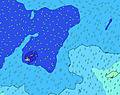 | 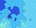 |  | 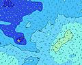 |  |  | 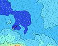 |  | |||||||||||||
Onda Altezza (m) Direzione Periodo (s) | SW 13 | SSW 13 | SSE 6 | S 12 | SSW 12 | SE 7 | NE 14 | SE 7 | SE 7 | NE 13 | NE 13 | NE 13 | NE 13 | NE 13 | NE 12 | NE 12 | NE 12 | NE 12 | NE 12 | NE 12 | NE 11 |
Grafico delle onde | |||||||||||||||||||||
0 | 0 | 0 | 0 | 0 | 0 | 169 | 0 | 0 | 111 | 142 | 109 | 85 | 83 | 74 | 72 | 90 | 71 | 69 | 65 | 75 | |
Vento (km/h) | |||||||||||||||||||||
Stato del vento onshore cross-onshore cross-shore cross-offshore offshore piatto | on | on | on | on | on | on | on | on | on | on | on | on | on | on | on | cross-on | cross-on | cross-on | cross-on | cross-on | cross-on |
Alta Marea | 7:17PM0.87m | 7:27AM0.98m | 7:54PM0.88m | 8:04AM0.97m | 8:32PM0.89m | ||||||||||||||||
Basso Marea | 1:09PM0.15m | 1:10AM0.20m | 1:45PM0.16m | 1:49AM0.21m | 2:20PM0.17m | ||||||||||||||||
6:45 | — | — | — | — | — | 6:43 | — | — | — | — | — | — | — | 6:43 | — | — | — | — | — | — | |
— | — | 6:12 | — | — | — | — | — | — | — | 6:12 | — | — | — | — | — | — | — | 6:13 | — | — | |
mm | — | — | — | — | — | — | — | — | — | — | — | — | — | — | — | — | 1 | — | — | — | — |
Temp. °C | 23 | 23 | 23 | 23 | 23 | 23 | 23 | 23 | 23 | 23 | 23 | 23 | 24 | 23 | 24 | 24 | 24 | 24 | 24 | 24 | 24 |
Gelo °C | 19 | 19 | 18 | 18 | 19 | 19 | 19 | 18 | 18 | 18 | 19 | 19 | 20 | 19 | 20 | 21 | 20 | 20 | 20 | 22 | 22 |
Onda 1 Altezza (m) Direzione Periodo (s) | SW 13 | SSW 13 | SSW 12 | S 12 | SSW 12 | S 12 | SSW 12 | SSW 11 | SSW 11 | NE 13 | S 11 | S 11 | S 11 | S 11 | S 10 | S 10 | S 10 | S 10 | S 10 | SSE 12 | SSE 12 |
290 | 273 | 256 | 299 | 361 | 284 | 343 | 325 | 314 | 111 | 466 | 515 | 338 | 332 | 270 | 244 | 198 | 194 | 158 | 213 | 230 | |
Onda 2 Altezza (m) Direzione Periodo (s) | SSW 13 | SW 13 | SW 13 | SW 13 | SW 13 | SW 12 | NE 14 | SSE 12 | SSE 12 | SSE 12 | NE 13 | NE 13 | NE 13 | NE 13 | NE 12 | SSE 13 | SSE 13 | SSE 13 | SSE 12 | S 10 | S 10 |
282 | 239 | 199 | 196 | 193 | 153 | 169 | 98 | 96 | 94 | 142 | 109 | 85 | 83 | 74 | 147 | 147 | 145 | 175 | 70 | 70 | |
Onda 3 Altezza (m) Direzione Periodo (s) | SSE 13 | SSE 13 | SSE 13 | SSE 13 | SSE 13 | SSE 12 | SW 12 | SW 12 | SW 12 | SW 12 | SSE 12 | SSE 11 | SSE 11 | SW 12 | SSE 11 | NE 12 | NE 12 | NE 12 | NE 12 | NE 12 | NE 11 |
198 | 198 | 151 | 149 | 145 | 136 | 124 | 95 | 92 | 52 | 91 | 74 | 49 | 49 | 49 | 72 | 90 | 71 | 69 | 65 | 75 | |
onde vento Altezza (m) Direzione Periodo (s) | SSE 6 | SE 6 | SSE 6 | SE 6 | SE 6 | SE 7 | SE 7 | SE 7 | SE 7 | SSE 11 | ESE 7 | ESE 7 | ESE 7 | ESE 7 | ESE 7 | ESE 7 | E 7 | ESE 7 | ESE 7 | ESE 7 | ESE 7 |
202 | 253 | 286 | 312 | 296 | 325 | 298 | 306 | 331 | 1074 | 198 | 197 | 241 | 268 | 265 | 219 | 218 | 232 | 247 | 327 | 294 | |
Il più vicino Offshore or Glassy | |||||||||||||||||||||
Distanza (km) | 1358 | 1358 | 907 | 1358 | 1358 | 909 | 909 | 623 | 909 | 909 | 909 | 909 | 1358 | 909 | 1249 | 1249 | 623 | 623 | 193 | 2 | 2 |
Migliori previsioni per le condizioni d'onda in American-Samoa - Tutuila | |||||||||||||||||||||
Migliori previsioni per le condizioni d'onda in American Samoa | |||||||||||||||||||||
Trova Onde Globale | |||||||||||||||||||||
- Map Icons:
 Break
Break Live Wave Height (m)
 Live Wind Speed (km/h)
 Surf Rating (10 Max)
 Ocean Swells (m)
- Wind Speed (km/h)
Widget Free Surf-Forecast.com per il tuo sito
La relazione di surf / widget meteo è disponibile qui sotto per incorporare su siti esterni a titolo gratuito e fornisce una sintesi delle nostre Alao previsione surf. Basta prendere il frammento di codice html da noi fornito e copiarlo nel proprio sito. È possibile scegliere la lingua preferita e unità metriche / imperiali per il feed delle previsioni surf per soddisfare le esigenze degli utenti del vostro sito .... Clicca qui per ottenere il codice.
 Nearest