
Previsioni:

Previsione a breve terminePioggia moderata (Totale 10mm), più pesante Sabato pomeriggio. Warm (Max 26°C giovedì mattina, Min 25°C giovedì mattina). Principalmente venti freschi. | |||||||||||||||||||||||
Giovedì 23 | Venerdì 24 | Sabato 25 | |||||||||||||||||||||
4 AM | 7 AM | 10 AM | 1 PM | 4 PM | 7 PM | 10 PM | 1 AM | 4 AM | 7 AM | 10 AM | 1 PM | 4 PM | 7 PM | 10 PM | 1 AM | 4 AM | 7 AM | 10 AM | 1 PM | 4 PM | 7 PM | 10 PM | |
Mappa dell'altezza del moto ondoso |  |  |  |  | 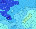 |  |  | 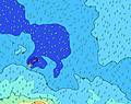 |  | ||||||||||||||
Onda Altezza (m) Direzione Periodo (s) | SSW 16 | SSW 15 | SSW 15 | SSW 14 | SSW 14 | SSW 14 | SSW 14 | SSW 13 | S 13 | SSW 13 | SSW 13 | SSW 12 | S 13 | S 12 | S 12 | S 12 | S 13 | S 13 | S 13 | S 13 | S 13 | S 12 | S 12 |
Grafico delle onde | |||||||||||||||||||||||
966 | 917 | 754 | 734 | 622 | 605 | 555 | 531 | 355 | 515 | 700 | 569 | 1094 | 1109 | 1209 | 1363 | 1181 | 1329 | 1329 | 1181 | 1028 | 874 | 846 | |
Vento (km/h) | |||||||||||||||||||||||
Stato del vento onshore cross-onshore cross-shore cross-offshore offshore piatto | cross | cross-on | cross-on | cross-on | cross-on | cross-on | cross-on | cross-on | cross-on | cross-on | cross-on | cross | cross | cross | cross | cross | cross | cross | cross | cross | cross | cross | cross |
Alta Marea | 2:47AM0.90m | 3:18PM0.78m | 3:33AM0.91m | 4:05PM0.78m | 4:16AM0.92m | 4:46PM0.80m | |||||||||||||||||
Basso Marea | 9:19AM0.28m | 9:15PM0.31m | 10:05AM0.25m | 9:59PM0.29m | 10:46AM0.23m | ||||||||||||||||||
6:47 | — | — | — | — | — | — | — | 6:47 | — | — | — | — | — | — | — | 6:47 | — | — | — | — | — | — | |
— | — | — | — | 6:12 | — | — | — | — | — | — | — | 6:12 | — | — | — | — | — | — | — | 6:12 | — | — | |
mm | 1 | 1 | — | — | — | — | — | — | — | — | — | — | — | — | — | — | — | — | — | 1 | 2 | 2 | 2 |
Temp. °C | 25 | 26 | 26 | 25 | 25 | 25 | 25 | 25 | 25 | 25 | 25 | 26 | 26 | 26 | 25 | 25 | 26 | 26 | 26 | 26 | 26 | 26 | 25 |
Gelo °C | 27 | 27 | 25 | 23 | 23 | 24 | 24 | 24 | 25 | 24 | 24 | 26 | 26 | 26 | 24 | 24 | 26 | 26 | 26 | 26 | 27 | 27 | 25 |
Onda 1 Altezza (m) Direzione Periodo (s) | SSW 16 | SSW 15 | SSW 15 | SSW 14 | SSW 14 | SSW 14 | SSW 14 | SSW 13 | S 13 | SSW 13 | SSW 13 | SSW 12 | S 13 | S 12 | S 12 | S 12 | S 13 | S 13 | S 13 | S 13 | S 13 | S 12 | S 12 |
966 | 917 | 754 | 734 | 622 | 605 | 555 | 531 | 355 | 515 | 700 | 569 | 1094 | 1109 | 1209 | 1363 | 1181 | 1329 | 1329 | 1181 | 1028 | 874 | 846 | |
Onda 2 Altezza (m) Direzione Periodo (s) | E 7 | SSE 10 | SE 12 | SE 12 | SSE 12 | SE 11 | SE 11 | SE 11 | SSW 10 | SE 11 | SE 10 | S 14 | SE 10 | SE 10 | SW 15 | SW 15 | SW 15 | SW 15 | SW 15 | SW 14 | SW 14 | SW 13 | SW 13 |
61 | 63 | 112 | 110 | 90 | 59 | 57 | 56 | 111 | 55 | 37 | 329 | 26 | 26 | 57 | 59 | 58 | 76 | 75 | 74 | 70 | 63 | 87 | |
Onda 3 Altezza (m) Direzione Periodo (s) | SSE 10 | SW 13 | SW 13 | SW 12 | SW 12 | SW 12 | SW 12 | SW 12 | SE 11 | S 17 | S 16 | SE 10 | NE 9 | NE 9 | SE 10 | SE 10 | NE 8 | NE 8 | NE 8 | NE 8 | SE 16 | SE 16 | SE 16 |
85 | 82 | 101 | 77 | 75 | 40 | 37 | 24 | 56 | 89 | 83 | 26 | 20 | 19 | 16 | 17 | 11 | 11 | 11 | 11 | 69 | 65 | 64 | |
onde vento Altezza (m) Direzione Periodo (s) | — | ESE 7 | ESE 7 | SE 7 | SE 5 | SE 5 | SE 5 | ESE 5 | ESE 7 | ESE 7 | ESE 7 | E 7 | E 7 | E 7 | E 7 | E 7 | ESE 6 | E 7 | ESE 7 | ESE 6 | ESE 6 | ESE 5 | ESE 7 |
— | 63 | 83 | 118 | 66 | 68 | 67 | 61 | 131 | 131 | 117 | 109 | 88 | 69 | 53 | 40 | 82 | 70 | 73 | 67 | 50 | 43 | 73 | |
Il più vicino Offshore or Glassy | |||||||||||||||||||||||
Distanza (km) | 1 | 17 | 886 | 886 | 886 | 604 | 604 | 604 | 604 | 604 | 604 | 27 | 1 | 171 | 601 | 171 | 1 | 1 | 1 | 1 | 1 | 1 | 1 |
Migliori previsioni per le condizioni d'onda in American-Samoa - Tutuila | |||||||||||||||||||||||
Migliori previsioni per le condizioni d'onda in American Samoa | |||||||||||||||||||||||
Trova Onde Globale | |||||||||||||||||||||||
- Map Icons:
 Break
Break Live Wave Height (m)
 Live Wind Speed (km/h)
 Surf Rating (10 Max)
 Ocean Swells (m)
- Wind Speed (km/h)
Widget Free Surf-Forecast.com per il tuo sito
La relazione di surf / widget meteo è disponibile qui sotto per incorporare su siti esterni a titolo gratuito e fornisce una sintesi delle nostre Asili Point previsione surf. Basta prendere il frammento di codice html da noi fornito e copiarlo nel proprio sito. È possibile scegliere la lingua preferita e unità metriche / imperiali per il feed delle previsioni surf per soddisfare le esigenze degli utenti del vostro sito .... Clicca qui per ottenere il codice.
 Nearest