
Previsioni:

Previsione a breve termineper lo più asciutto. Very mild (Max 19°C Venerdì mattina, Min 11°C mercoledì notte). Vento sarà generalmente leggero. | ||||||||||||||||||||||||
Mercoledì 29 | Giovedì 30 | Venerdì 31 | ||||||||||||||||||||||
2 AM | 5 AM | 8 AM | 11 AM | 2 PM | 5 PM | 8 PM | 11 PM | 2 AM | 5 AM | 8 AM | 11 AM | 2 PM | 5 PM | 8 PM | 11 PM | 2 AM | 5 AM | 8 AM | 11 AM | 2 PM | 5 PM | 8 PM | 11 PM | |
Mappa dell'altezza del moto ondoso |  |  |  |  | 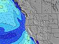 |  |  | 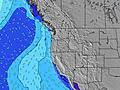 |  | |||||||||||||||
Onda Altezza (m) Direzione Periodo (s) | SW 17 | SW 17 | SW 17 | SW 17 | SW 17 | SW 16 | SW 16 | SW 16 | SW 16 | SW 16 | SW 16 | SW 16 | SW 16 | SW 16 | SW 16 | SW 16 | SW 15 | SW 15 | SW 15 | SW 15 | SW 15 | SW 14 | SW 14 | SW 14 |
Grafico delle onde | ||||||||||||||||||||||||
434 | 594 | 499 | 493 | 410 | 318 | 376 | 376 | 310 | 306 | 306 | 302 | 299 | 295 | 291 | 287 | 233 | 224 | 215 | 209 | 209 | 206 | 206 | 206 | |
Vento (km/h) | ||||||||||||||||||||||||
Stato del vento onshore cross-onshore cross-shore cross-offshore offshore piatto | cross-off | cross-off | cross-off | cross-on | cross-on | cross-on | cross-on | cross | glassy | glassy | glassy | cross-on | cross-on | cross-on | cross | cross | cross-off | off | glassy | cross-on | cross-on | cross-on | cross-on | glassy |
Alta Marea | 00:02AM2.43m | 1:53PM1.92m | 00:40AM2.43m | 2:20PM1.99m | 1:19AM2.38m | 2:48PM2.06m | ||||||||||||||||||
Basso Marea | 7:16AM-0.22m | 6:57PM0.98m | 7:47AM-0.23m | 7:36PM0.89m | 8:16AM-0.18m | 8:18PM0.80m | ||||||||||||||||||
— | 5:58 | — | — | — | — | — | — | — | 6:00 | — | — | — | — | — | — | — | 6:01 | — | — | — | — | — | — | |
— | — | — | — | — | — | 8:45 | — | — | — | — | — | — | — | 8:44 | — | — | — | — | — | — | — | 8:43 | — | |
mm | — | — | — | — | — | — | — | — | — | — | — | — | — | — | — | — | — | — | — | — | — | — | — | — |
Temp. °C | 13 | 13 | 13 | 16 | 16 | 16 | 14 | 13 | 12 | 11 | 12 | 16 | 17 | 17 | 15 | 14 | 13 | 13 | 15 | 19 | 19 | 18 | 16 | 15 |
Gelo °C | 12 | 12 | 12 | 14 | 13 | 13 | 12 | 12 | 12 | 11 | 12 | 15 | 15 | 15 | 13 | 13 | 12 | 11 | 14 | 17 | 16 | 16 | 15 | 16 |
Onda 1 Altezza (m) Direzione Periodo (s) | WNW 8 | WNW 9 | WNW 9 | WNW 9 | WNW 9 | WNW 9 | WNW 8 | WNW 8 | WNW 8 | WNW 8 | WNW 8 | WNW 8 | WNW 8 | SW 16 | SW 16 | SW 16 | WNW 9 | WNW 9 | WNW 9 | WNW 9 | WNW 8 | W 8 | W 8 | W 8 |
159 | 232 | 238 | 243 | 257 | 212 | 202 | 169 | 153 | 128 | 128 | 94 | 75 | 295 | 291 | 287 | 111 | 137 | 137 | 134 | 127 | 147 | 140 | 137 | |
Onda 2 Altezza (m) Direzione Periodo (s) | SW 17 | SW 17 | SW 17 | SW 17 | SW 17 | SW 16 | SW 16 | SW 16 | SW 16 | SW 16 | SW 16 | SW 16 | SW 16 | WNW 8 | WNW 8 | WNW 8 | SW 15 | SW 15 | SW 15 | SW 15 | SW 15 | SW 14 | SW 14 | SW 14 |
434 | 594 | 499 | 493 | 410 | 318 | 376 | 376 | 310 | 306 | 306 | 302 | 299 | 73 | 75 | 80 | 233 | 224 | 215 | 209 | 209 | 206 | 206 | 206 | |
Onda 3 Altezza (m) Direzione Periodo (s) | SW 12 | — | — | — | SW 12 | SW 12 | SSW 11 | SSW 11 | SSW 11 | SSW 11 | SW 11 | SW 11 | SSW 11 | SSW 11 | SSW 10 | SSW 10 | SW 10 | SSW 11 | — | — | — | SW 8 | SW 8 | — |
36 | — | — | — | 35 | 35 | 24 | 24 | 24 | 11 | 18 | 18 | 11 | 11 | 9 | 9 | 4 | 11 | — | — | — | 3 | 3 | — | |
onde vento Altezza (m) Direzione Periodo (s) | — | — | — | — | NNW 4 | NNW 4 | — | — | — | — | — | — | — | — | — | — | — | — | — | — | — | NW 3 | NW 3 | — |
— | — | — | — | 9 | 10 | — | — | — | — | — | — | — | — | — | — | — | — | — | — | — | 2 | 2 | — | |
Il più vicino Offshore or Glassy | ||||||||||||||||||||||||
Distanza (km) | 8 | 8 | 8 | 252 | 876 | 875 | 569 | 8 | 8 | 8 | 8 | 178 | 413 | 511 | 178 | 8 | 8 | 8 | 8 | 178 | 323 | 496 | 143 | 8 |
Migliori previsioni per le condizioni d'onda in South Oregon | ||||||||||||||||||||||||
Migliori previsioni per le condizioni d'onda in United States | ||||||||||||||||||||||||
Trova Onde Globale | ||||||||||||||||||||||||
- Map Icons:
 Break
Break Live Wave Height (m)
 Live Wind Speed (km/h)
 Surf Rating (10 Max)
 Ocean Swells (m)
- Wind Speed (km/h)
Widget Free Surf-Forecast.com per il tuo sito
La relazione di surf / widget meteo è disponibile qui sotto per incorporare su siti esterni a titolo gratuito e fornisce una sintesi delle nostre Avalanche previsione surf. Basta prendere il frammento di codice html da noi fornito e copiarlo nel proprio sito. È possibile scegliere la lingua preferita e unità metriche / imperiali per il feed delle previsioni surf per soddisfare le esigenze degli utenti del vostro sito .... Clicca qui per ottenere il codice.
 Nearest