
Batu Mandi Surf Guide
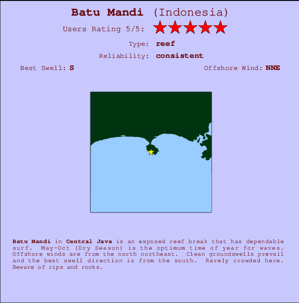
Batu Mandi in Central Java is an exposed reef break that has reliable surf. May-Oct (Dry Season) is the best time of year for waves. Works best in offshore winds from the north northeast. Most of the surf here comes from groundswells and the best swell direction is from the south. A reef breaks left. Unlikely to be too crowded, even when the surf is up. Hazards include rips and rocks.
Batu Mandi Spot Info
| Type: | Rating: | Reliability: | Todays Sea Temp*: |
|---|---|---|---|
| consistent | 26.0°C*ocean temperature recorded from satellite |
Surfing Batu Mandi:
The best conditions reported for surf at Batu Mandi occur when a South swell combines with an offshore wind direction from the North-northeast.

Previsioni Energia d'onda (Potenza): 12hrs


Batu Mandi Surf:
Tuesday, 28 July 2026, 13:44 Local time| Martedì 28 | ||||
| 10AM | 1PM | 4PM | 7PM | |
| Wave (m) | ||||
| Periodo (s) | 8 | 8 | 8 | 8 |
| Vento (km/h) | ||||
| Stato del vento | cross | cross | cross | cross- off |
- /breaks/Batu-Mandi/forecasts/latest
Batu Mandi Surf Guide
Batu Mandi in Central Java is an exposed reef break that has reliable surf. May-Oct (Dry Season) is the best time of year for waves. Works best in offshore winds from the north northeast. Most of the surf here comes from groundswells and the best swell direction is from the south. A reef breaks left. Unlikely to be too crowded, even when the surf is up. Hazards include rips and rocks.
Batu Mandi Spot Info
Type: Rating: Reliability: Todays Sea Temp*:  Reef
Reef 5
5consistent 26.0°C*ocean temperature recorded from satelliteSurfing Batu Mandi:
The best conditions reported for surf at Batu Mandi occur when a South swell combines with an offshore wind direction from the North-northeast.
Previsioni Energia d'onda (Potenza): 12hrs
Utilizzare la scheda di navigazione in alto per visualizzare Batu Mandi temperatura del mare, Batu Mandi fotografie, Batu Mandi dettagliate previsioni onde, il vento e le previsioni meteo, Batu Mandi webcam, vento corrente da Java - Central stazioni meteo e Batu Mandi previsioni marea. Il link Indonesia mappe maree apre l'immagine grande, che mostra Indonesia e dei mari circostanti. Queste mappe possono essere animate per mostrare le diverse componenti del moto ondoso, energia delle onde, periodo d'onda, altezza delle onde, insieme con le previsioni del vento e meteo, meteo corrente e osservazioni sullo stato del mare dal Indonesia onda-boe, le navi passanti e stazioni meteo costiere. Ciascuna delle pagine di previsioni per questo surf break rappresenta uno strumento di wavefinder globale e regionale per individuare le migliori condizioni di surf nella zona intorno Batu Mandi.
Batu Mandi Surf:
Tuesday, 28 July 2026, 13:44 Local timeMartedì 28 10AM 1PM 4PM 7PM Wave (m) Periodo (s) 8 8 8 8 Vento (km/h) Stato del vento cross cross cross cross-
off- /breaks/Batu-Mandi/forecasts/latest
- /breaks/Batu-Mandi/forecasts/latest/six_day
Batu Mandi Surf Guide
Batu Mandi in Central Java is an exposed reef break that has reliable surf. May-Oct (Dry Season) is the best time of year for waves. Works best in offshore winds from the north northeast. Most of the surf here comes from groundswells and the best swell direction is from the south. A reef breaks left. Unlikely to be too crowded, even when the surf is up. Hazards include rips and rocks.
Batu Mandi Spot Info
Type: Rating: Reliability: Todays Sea Temp*: Reef5consistent 26.0°C*ocean temperature recorded from satelliteSurfing Batu Mandi:
The best conditions reported for surf at Batu Mandi occur when a South swell combines with an offshore wind direction from the North-northeast.
Previsioni Energia d'onda (Potenza): 12hrs
Utilizzare la scheda di navigazione in alto per visualizzare Batu Mandi temperatura del mare, Batu Mandi fotografie, Batu Mandi dettagliate previsioni onde, il vento e le previsioni meteo, Batu Mandi webcam, vento corrente da Java - Central stazioni meteo e Batu Mandi previsioni marea. Il link Indonesia mappe maree apre l'immagine grande, che mostra Indonesia e dei mari circostanti. Queste mappe possono essere animate per mostrare le diverse componenti del moto ondoso, energia delle onde, periodo d'onda, altezza delle onde, insieme con le previsioni del vento e meteo, meteo corrente e osservazioni sullo stato del mare dal Indonesia onda-boe, le navi passanti e stazioni meteo costiere. Ciascuna delle pagine di previsioni per questo surf break rappresenta uno strumento di wavefinder globale e regionale per individuare le migliori condizioni di surf nella zona intorno Batu Mandi.
Batu Mandi Surf:
Tuesday, 28 July 2026, 13:44 Local timeMartedì 28 10AM 1PM 4PM 7PM Wave (m) Periodo (s) 8 8 8 8 Vento (km/h) Stato del vento cross cross cross cross-
off- /breaks/Batu-Mandi/forecasts/latest
Batu Mandi Surf Guide
Batu Mandi in Central Java is an exposed reef break that has reliable surf. May-Oct (Dry Season) is the best time of year for waves. Works best in offshore winds from the north northeast. Most of the surf here comes from groundswells and the best swell direction is from the south. A reef breaks left. Unlikely to be too crowded, even when the surf is up. Hazards include rips and rocks.
Batu Mandi Spot Info
Type: Rating: Reliability: Todays Sea Temp*: Reef5consistent 26.0°C*ocean temperature recorded from satelliteSurfing Batu Mandi:
The best conditions reported for surf at Batu Mandi occur when a South swell combines with an offshore wind direction from the North-northeast.
Previsioni Energia d'onda (Potenza): 12hrs
Utilizzare la scheda di navigazione in alto per visualizzare Batu Mandi temperatura del mare, Batu Mandi fotografie, Batu Mandi dettagliate previsioni onde, il vento e le previsioni meteo, Batu Mandi webcam, vento corrente da Java - Central stazioni meteo e Batu Mandi previsioni marea. Il link Indonesia mappe maree apre l'immagine grande, che mostra Indonesia e dei mari circostanti. Queste mappe possono essere animate per mostrare le diverse componenti del moto ondoso, energia delle onde, periodo d'onda, altezza delle onde, insieme con le previsioni del vento e meteo, meteo corrente e osservazioni sullo stato del mare dal Indonesia onda-boe, le navi passanti e stazioni meteo costiere. Ciascuna delle pagine di previsioni per questo surf break rappresenta uno strumento di wavefinder globale e regionale per individuare le migliori condizioni di surf nella zona intorno Batu Mandi.
Batu Mandi Surf:
Tuesday, 28 July 2026, 13:44 Local timeMartedì 28 10AM 1PM 4PM 7PM Wave (m) Periodo (s) 8 8 8 8 Vento (km/h) Stato del vento cross cross cross cross-
offTide Times:
A Batu Mandi (0 km).
PROSSIMA È ALLE (ora locale) rimanente alta marea bassa marea Batu Mandi Tide Times and Tide Chart
Live Weather:
At Pamijen Lor wx, 75 km from Batu Mandi.
- Air temperature
32°COverall Batu Mandi Surf Consistency and Wind Distribution in Luglio
foto dall' album
Contorni: Strade e fiumi: seleziona un surf break dal menu 


Utilizzare questa mappa sollievo per navigare Java - Central surf breaks e stazioni di marea che si trovano nella zona diBatu Mandi
Altri surf breaks più vicini al Batu Mandi:
(clicca sul nome del luogo per maggiori informazioni)- Closest località surf5 mi
- Second closest località surf9 mi
- Third closest località surf11 mi
- Fourth closest località surf14 mi
- Fifth closest località surf153 mi
Onda boe più vicina a Batu Mandi:
- Closest Onda boa2271 mi
- Second closest Onda boa2451 mi
- Third closest Onda boa2513 mi
- Fourth closest Onda boa2576 mi
- Fifth closest Onda boa2637 mi
Stazioni di marea più vicina alla Batu Mandi:
- Closest marea stazioneAstanajapura64 mi
- Second closest marea stazioneCirebon67 mi
- Third closest marea stazioneTegal67 mi
- Fourth closest marea stazionePemalang75 mi
- Fifth closest marea stazionePetarukan79 mi
Airports
- The closest passenger airport to Batu Mandi is Tunggul Wulung (Cilacap) Airport (CXP) in Indonesia, 42 km (26 miles) away (directly).
- The second nearest airport to Batu Mandi is Penggung (Cirebon) Airport (CBN), also in Indonesia, 109 km (68 miles) away.
- Third is Husein Sastranegara (Bandung) Airport (BDO) in Indonesia, 151 km (94 miles) away.
- Adi Sutjipto (Yogyakarta) Airport (JOG) in Indonesia is 196 km (122 miles) away.
- Achmad Yani (Semarang) Airport (SRG), also in Indonesia is the fifth nearest airport to Batu Mandi and is 207 km (129 miles) away.
- /breaks/Batu-Mandi/forecasts/latest


 Nearest