
Previsioni:

Previsione a breve termineper lo più asciutto. Very mild (Max 18°C martedì pomeriggio, Min 13°C Lunedì mattina). Vento sarà generalmente leggero. | ||||||||||||||||||||||||
Lunedì 3 | Martedì 4 | Mercoledì 5 | ||||||||||||||||||||||
2 AM | 5 AM | 8 AM | 11 AM | 2 PM | 5 PM | 8 PM | 11 PM | 2 AM | 5 AM | 8 AM | 11 AM | 2 PM | 5 PM | 8 PM | 11 PM | 2 AM | 5 AM | 8 AM | 11 AM | 2 PM | 5 PM | 8 PM | 11 PM | |
Mappa dell'altezza del moto ondoso |  | 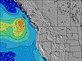 | 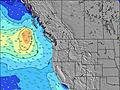 | 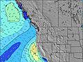 | 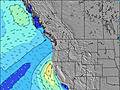 | 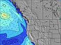 | 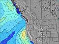 | 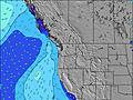 | 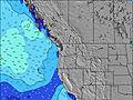 | |||||||||||||||
Onda Altezza (m) Direzione Periodo (s) | WNW 8 | WNW 8 | WNW 8 | WNW 7 | WNW 7 | WNW 7 | NW 7 | NW 6 | NW 6 | WNW 7 | WNW 7 | WNW 7 | WNW 7 | WNW 7 | NW 8 | WNW 8 | WNW 8 | WNW 8 | WNW 8 | WNW 8 | WNW 8 | WNW 8 | WNW 8 | WNW 8 |
Grafico delle onde | ||||||||||||||||||||||||
273 | 218 | 169 | 167 | 139 | 108 | 204 | 161 | 123 | 107 | 124 | 140 | 160 | 142 | 288 | 300 | 274 | 291 | 370 | 370 | 323 | 323 | 280 | 307 | |
Vento (km/h) | ||||||||||||||||||||||||
Stato del vento onshore cross-onshore cross-shore cross-offshore offshore piatto | off | cross-off | glassy | cross | cross | cross-off | cross-off | cross-off | off | glassy | glassy | cross | cross-off | cross-off | cross-off | cross-off | cross-off | cross-off | glassy | cross-on | cross | cross-off | cross-off | cross-off |
Alta Marea | 3:48AM2.05m | 4:27PM2.30m | 4:40AM1.87m | 5:02PM2.35m | 5:43AM1.69m | 5:45PM2.37m | ||||||||||||||||||
Basso Marea | 9:49AM0.11m | 10:36PM0.32m | 10:25AM0.32m | 11:33PM0.23m | 11:08AM0.54m | |||||||||||||||||||
— | 5:56 | — | — | — | — | — | — | — | 5:58 | — | — | — | — | — | — | — | 6:00 | — | — | — | — | — | — | |
— | — | — | — | — | — | 8:47 | — | — | — | — | — | — | — | 8:46 | — | — | — | — | — | — | — | 8:45 | — | |
mm | — | — | — | — | — | — | — | — | — | — | — | — | — | — | — | — | — | — | — | — | — | — | — | — |
Temp. °C | 13 | 13 | 13 | 15 | 17 | 16 | 16 | 15 | 15 | 14 | 15 | 17 | 18 | 18 | 16 | 15 | 15 | 14 | 15 | 17 | 17 | 17 | 15 | 14 |
Gelo °C | 11 | 12 | 13 | 14 | 14 | 12 | 12 | 11 | 13 | 13 | 15 | 16 | 15 | 15 | 13 | 12 | 13 | 13 | 15 | 16 | 16 | 15 | 13 | 13 |
Onda 1 Altezza (m) Direzione Periodo (s) | WNW 8 | WNW 8 | WNW 8 | WNW 7 | WNW 7 | WNW 7 | SW 13 | SW 13 | SW 13 | WNW 7 | WNW 7 | WNW 7 | WNW 7 | WNW 9 | SW 16 | SW 16 | WNW 8 | WNW 8 | WNW 8 | WNW 8 | WNW 8 | WNW 8 | WNW 8 | WNW 8 |
273 | 218 | 169 | 167 | 139 | 108 | 43 | 26 | 26 | 107 | 124 | 140 | 160 | 48 | 64 | 61 | 274 | 291 | 370 | 370 | 323 | 323 | 280 | 307 | |
Onda 2 Altezza (m) Direzione Periodo (s) | SW 13 | SW 13 | SW 13 | SW 13 | SW 13 | SW 13 | WSW 17 | WSW 16 | SW 16 | WSW 16 | SW 16 | SW 16 | WNW 9 | SW 16 | SSW 12 | SW 12 | SW 15 | SW 15 | SW 15 | SW 15 | WSW 15 | WSW 15 | SW 14 | SW 14 |
63 | 62 | 62 | 61 | 61 | 44 | 29 | 26 | 66 | 51 | 66 | 66 | 29 | 65 | 15 | 6 | 58 | 57 | 56 | 55 | 42 | 42 | 74 | 72 | |
Onda 3 Altezza (m) Direzione Periodo (s) | WSW 18 | WSW 18 | WSW 18 | WSW 18 | WSW 18 | WSW 18 | — | — | SW 13 | SW 13 | SW 13 | SW 13 | SW 16 | SW 12 | SSW 12 | S 14 | SW 12 | SW 12 | SW 12 | SW 12 | SW 12 | SW 12 | W 21 | SW 21 |
31 | 61 | 61 | 31 | 30 | 30 | — | — | 27 | 26 | 26 | 26 | 65 | 24 | 14 | 4 | 6 | 6 | 6 | 6 | 6 | 6 | 9 | 18 | |
onde vento Altezza (m) Direzione Periodo (s) | — | — | — | — | — | NNW 4 | NW 7 | NW 6 | NW 6 | — | — | — | — | WNW 7 | NW 8 | WNW 8 | — | — | — | — | — | — | — | — |
— | — | — | — | — | 8 | 204 | 161 | 123 | — | — | — | — | 142 | 288 | 300 | — | — | — | — | — | — | — | — | |
Il più vicino Offshore or Glassy | ||||||||||||||||||||||||
Distanza (km) | 0 | 0 | 0 | 48 | 119 | 119 | 621 | 111 | 0 | 0 | 0 | 48 | 0 | 605 | 605 | 109 | 0 | 0 | 0 | 94 | 94 | 560 | 0 | 0 |
Migliori previsioni per le condizioni d'onda in Washington State | ||||||||||||||||||||||||
Migliori previsioni per le condizioni d'onda in United States | ||||||||||||||||||||||||
Trova Onde Globale | ||||||||||||||||||||||||
- Map Icons:
 Break
Break Live Wave Height (m)
 Live Wind Speed (km/h)
 Surf Rating (10 Max)
 Ocean Swells (m)
- Wind Speed (km/h)
Widget Free Surf-Forecast.com per il tuo sito
La relazione di surf / widget meteo è disponibile qui sotto per incorporare su siti esterni a titolo gratuito e fornisce una sintesi delle nostre Cape Elizabeth previsione surf. Basta prendere il frammento di codice html da noi fornito e copiarlo nel proprio sito. È possibile scegliere la lingua preferita e unità metriche / imperiali per il feed delle previsioni surf per soddisfare le esigenze degli utenti del vostro sito .... Clicca qui per ottenere il codice.
 Nearest