
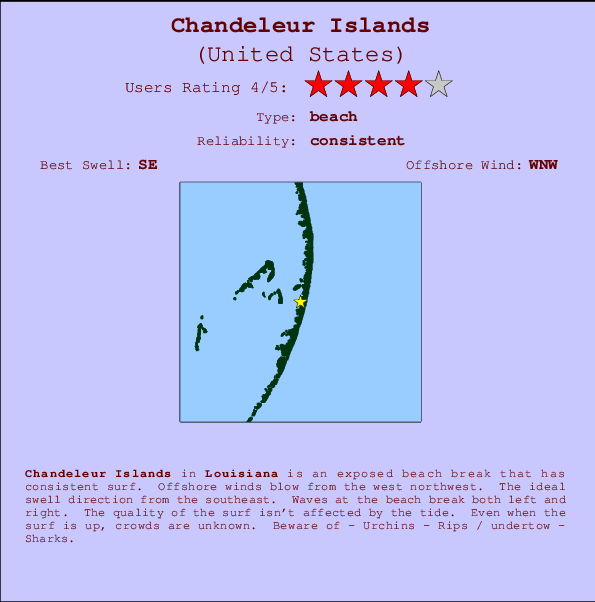
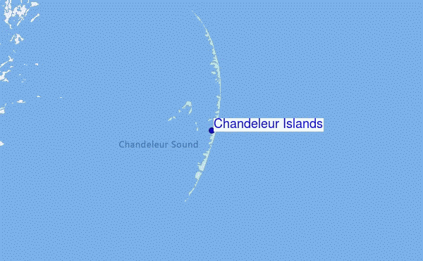
Chandeleur Islands Surf Guide
Chandeleur Islands in Louisiana is an exposed beach break that has reliable surf. The best wind direction is from the west northwest. The optimum well angle is from the southeast. Waves at the beach break both left and right. Good surf at all stages of the tide. The location means that it never gets crowded. Beware of - Urchins - Rips / undertow - Sharks.
Chandeleur Islands Spot Info
| Type: | Rating: | Reliability: | Todays Sea Temp*: |
|---|---|---|---|
| consistent | 30.8°C*ocean temperature recorded from satellite |
Surfing Chandeleur Islands:
The best conditions reported for surf at Chandeleur Islands occur when a Southeast swell combines with an offshore wind direction from the West-northwest.
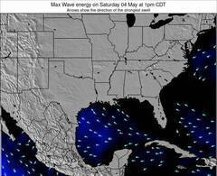
Previsioni Energia d'onda (Potenza): 12hrs
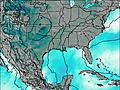
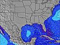
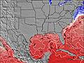
Chandeleur Islands Surf:
Friday, 31 July 2026, 20:34 Local time| Venerdì 31 | ||||
| 4PM | 7PM | 10PM | 1AM | |
| Wave (m) | ||||
| Periodo (s) | - | - | - | - |
| Vento (km/h) | ||||
| Stato del vento | cross- off |
cross- off |
cross- off |
cross- off |
- /breaks/Chandeleur-Islands/forecasts/latest
Chandeleur Islands Surf Guide
Chandeleur Islands in Louisiana is an exposed beach break that has reliable surf. The best wind direction is from the west northwest. The optimum well angle is from the southeast. Waves at the beach break both left and right. Good surf at all stages of the tide. The location means that it never gets crowded. Beware of - Urchins - Rips / undertow - Sharks.
Chandeleur Islands Spot Info
Type: Rating: Reliability: Todays Sea Temp*:  Beach
Beach 4
4consistent 30.8°C*ocean temperature recorded from satelliteSurfing Chandeleur Islands:
The best conditions reported for surf at Chandeleur Islands occur when a Southeast swell combines with an offshore wind direction from the West-northwest.
Previsioni Energia d'onda (Potenza): 12hrs
Utilizzare la scheda di navigazione in alto per visualizzare Chandeleur Islands temperatura del mare, Chandeleur Islands fotografie, Chandeleur Islands dettagliate previsioni onde, il vento e le previsioni meteo, Chandeleur Islands webcam, vento corrente da Louisiana stazioni meteo e Chandeleur Islands previsioni marea. Il link United States mappe maree apre l'immagine grande, che mostra United States e dei mari circostanti. Queste mappe possono essere animate per mostrare le diverse componenti del moto ondoso, energia delle onde, periodo d'onda, altezza delle onde, insieme con le previsioni del vento e meteo, meteo corrente e osservazioni sullo stato del mare dal United States onda-boe, le navi passanti e stazioni meteo costiere. Ciascuna delle pagine di previsioni per questo surf break rappresenta uno strumento di wavefinder globale e regionale per individuare le migliori condizioni di surf nella zona intorno Chandeleur Islands.
Chandeleur Islands Surf:
Friday, 31 July 2026, 20:34 Local timeVenerdì 31 4PM 7PM 10PM 1AM Wave (m) Periodo (s) - - - - Vento (km/h) Stato del vento cross-
offcross-
offcross-
offcross-
off- /breaks/Chandeleur-Islands/forecasts/latest
- /breaks/Chandeleur-Islands/forecasts/latest/six_day
Chandeleur Islands Surf Guide
Chandeleur Islands in Louisiana is an exposed beach break that has reliable surf. The best wind direction is from the west northwest. The optimum well angle is from the southeast. Waves at the beach break both left and right. Good surf at all stages of the tide. The location means that it never gets crowded. Beware of - Urchins - Rips / undertow - Sharks.
Chandeleur Islands Spot Info
Type: Rating: Reliability: Todays Sea Temp*: Beach4consistent 30.8°C*ocean temperature recorded from satelliteSurfing Chandeleur Islands:
The best conditions reported for surf at Chandeleur Islands occur when a Southeast swell combines with an offshore wind direction from the West-northwest.
Previsioni Energia d'onda (Potenza): 12hrs
Utilizzare la scheda di navigazione in alto per visualizzare Chandeleur Islands temperatura del mare, Chandeleur Islands fotografie, Chandeleur Islands dettagliate previsioni onde, il vento e le previsioni meteo, Chandeleur Islands webcam, vento corrente da Louisiana stazioni meteo e Chandeleur Islands previsioni marea. Il link United States mappe maree apre l'immagine grande, che mostra United States e dei mari circostanti. Queste mappe possono essere animate per mostrare le diverse componenti del moto ondoso, energia delle onde, periodo d'onda, altezza delle onde, insieme con le previsioni del vento e meteo, meteo corrente e osservazioni sullo stato del mare dal United States onda-boe, le navi passanti e stazioni meteo costiere. Ciascuna delle pagine di previsioni per questo surf break rappresenta uno strumento di wavefinder globale e regionale per individuare le migliori condizioni di surf nella zona intorno Chandeleur Islands.
Chandeleur Islands Surf:
Friday, 31 July 2026, 20:34 Local timeVenerdì 31 4PM 7PM 10PM 1AM Wave (m) Periodo (s) - - - - Vento (km/h) Stato del vento cross-
offcross-
offcross-
offcross-
off- /breaks/Chandeleur-Islands/forecasts/latest
Chandeleur Islands Surf Guide
Chandeleur Islands in Louisiana is an exposed beach break that has reliable surf. The best wind direction is from the west northwest. The optimum well angle is from the southeast. Waves at the beach break both left and right. Good surf at all stages of the tide. The location means that it never gets crowded. Beware of - Urchins - Rips / undertow - Sharks.
Chandeleur Islands Spot Info
Type: Rating: Reliability: Todays Sea Temp*: Beach4consistent 30.8°C*ocean temperature recorded from satelliteSurfing Chandeleur Islands:
The best conditions reported for surf at Chandeleur Islands occur when a Southeast swell combines with an offshore wind direction from the West-northwest.
Previsioni Energia d'onda (Potenza): 12hrs
Utilizzare la scheda di navigazione in alto per visualizzare Chandeleur Islands temperatura del mare, Chandeleur Islands fotografie, Chandeleur Islands dettagliate previsioni onde, il vento e le previsioni meteo, Chandeleur Islands webcam, vento corrente da Louisiana stazioni meteo e Chandeleur Islands previsioni marea. Il link United States mappe maree apre l'immagine grande, che mostra United States e dei mari circostanti. Queste mappe possono essere animate per mostrare le diverse componenti del moto ondoso, energia delle onde, periodo d'onda, altezza delle onde, insieme con le previsioni del vento e meteo, meteo corrente e osservazioni sullo stato del mare dal United States onda-boe, le navi passanti e stazioni meteo costiere. Ciascuna delle pagine di previsioni per questo surf break rappresenta uno strumento di wavefinder globale e regionale per individuare le migliori condizioni di surf nella zona intorno Chandeleur Islands.
Chandeleur Islands Surf:
Friday, 31 July 2026, 20:34 Local timeVenerdì 31 4PM 7PM 10PM 1AM Wave (m) Periodo (s) - - - - Vento (km/h) Stato del vento cross-
offcross-
offcross-
offcross-
offTide Times:
A Chandeleur Islands (0 km).
PROSSIMA È ALLE (ora locale) rimanente alta marea bassa marea Chandeleur Islands Tide Times and Tide Chart
Live Weather:
At BUOY-PTBM6, 51 km from Chandeleur Islands.
moderate winds from the WSW
(km/h)Air temperature
30.1°COverall Chandeleur Islands Surf Consistency and Wind Distribution in Agosto
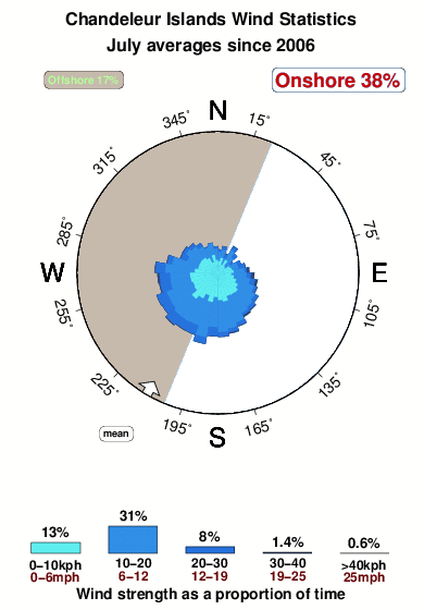


Wind stats for Chandeleur Islands: see the variation in direction and stength by month.
foto dall' album
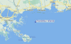
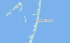
Contorni: Strade e fiumi: seleziona un surf break dal menu 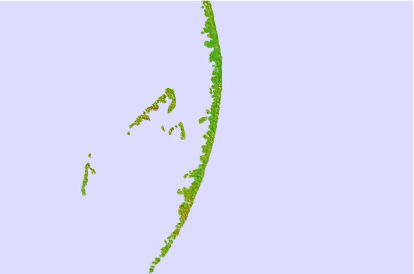

Utilizzare questa mappa sollievo per navigare Louisiana surf breaks e stazioni di marea che si trovano nella zona diChandeleur Islands
Altri surf breaks più vicini al Chandeleur Islands:
(clicca sul nome del luogo per maggiori informazioni)- Closest località surf53 mi
- Second closest località surf71 mi
- Third closest località surf81 mi
- Fourth closest località surf82 mi
- Fifth closest località surf83 mi
Onda boe più vicina a Chandeleur Islands:
- Closest Onda boa17 mi
- Second closest Onda boa78 mi
- Third closest Onda boa98 mi
- Fourth closest Onda boa116 mi
- Fifth closest Onda boa120 mi
Stazioni di marea più vicina alla Chandeleur Islands:
- Closest marea stazioneChandeleur Light14 mi
- Second closest marea stazioneComfort Island26 mi
- Third closest marea stazioneShip Island Sound27 mi
- Fourth closest marea stazioneShip Island Pass27 mi
- Fifth closest marea stazioneHorn Island Sound29 mi
Airports
- The closest passenger airport to Chandeleur Islands is Keesler Afb (Biloxi) Airport (BIX) in USA, 63 km (39 miles) away (directly).
- The second nearest airport to Chandeleur Islands is Mobile Rgnl Airport (MOB), also in USA, 110 km (68 miles) away.
- Third is Mobile Downtown Airport (BFM) in USA, 114 km (71 miles) away.
- New Orleans Nas Jrb Airport (NBG) in USA is 116 km (72 miles) away.
- Louis Armstrong New Orleans International Airport (MSY), also in USA is the fifth nearest airport to Chandeleur Islands and is 138 km (86 miles) away.
- /breaks/Chandeleur-Islands/forecasts/latest


 Nearest