
Previsioni:

Previsione a breve terminePioggia abbondante (Totale 36mm), più pesante durante lunedì mattina. Warm (Max 27°C Domenica mattina, Min 23°C Lunedì notte). Vento sarà generalmente leggero. | |||||||||||||||||||||
Dom 2 | Lunedì 3 | Martedì 4 | |||||||||||||||||||
11 AM | 2 PM | 5 PM | 8 PM | 11 PM | 2 AM | 5 AM | 8 AM | 11 AM | 2 PM | 5 PM | 8 PM | 11 PM | 2 AM | 5 AM | 8 AM | 11 AM | 2 PM | 5 PM | 8 PM | 11 PM | |
Mappa dell'altezza del moto ondoso | 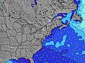 |  |  | 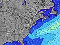 |  |  | 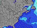 |  | |||||||||||||
Onda Altezza (m) Direzione Periodo (s) | SSE 4 | SSE 4 | SSE 4 | SSE 5 | S 5 | SSE 7 | SSE 8 | S 8 | SSE 8 | SSE 8 | S 8 | S 8 | SSE 7 | SSE 7 | SSE 7 | SSE 7 | SSE 7 | SSE 7 | SSE 7 | SSE 7 | SSE 7 |
Grafico delle onde | |||||||||||||||||||||
24 | 24 | 18 | 19 | 51 | 162 | 300 | 579 | 280 | 280 | 286 | 258 | 164 | 125 | 104 | 101 | 70 | 54 | 53 | 61 | 61 | |
Vento (km/h) | |||||||||||||||||||||
Stato del vento onshore cross-onshore cross-shore cross-offshore offshore piatto | on | on | cross-on | cross-on | cross-on | cross-on | cross-on | cross | cross | cross | cross | cross | cross-off | glassy | cross | cross | cross-on | on | on | on | cross-on |
Alta Marea | 11:05AM1.22m | 11:14PM1.26m | 11:47AM1.25m | 00:00AM1.20m | 12:33PM1.28m | ||||||||||||||||
Basso Marea | 5:18PM0.15m | 5:36AM0.02m | 6:01PM0.17m | 6:11AM0.05m | 6:51PM0.20m | ||||||||||||||||
— | — | — | — | — | — | 6:00 | — | — | — | — | — | — | — | 6:01 | — | — | — | — | — | — | |
— | — | — | 8:08 | — | — | — | — | — | — | — | 8:07 | — | — | — | — | — | — | — | 8:07 | — | |
mm | — | — | — | 1 | 3 | 2 | 3 | 4 | 4 | 4 | 2 | 2 | 3 | 1 | — | — | — | — | — | — | — |
Temp. °C | 25 | 26 | 27 | 25 | 24 | 24 | 24 | 24 | 24 | 26 | 25 | 24 | 24 | 24 | 23 | 23 | 24 | 25 | 24 | 24 | 24 |
Gelo °C | 25 | 27 | 29 | 27 | 25 | 24 | 24 | 25 | 25 | 26 | 26 | 26 | 28 | 28 | 25 | 24 | 25 | 26 | 25 | 26 | 25 |
Onda 1 Altezza (m) Direzione Periodo (s) | E 6 | E 5 | SE 7 | SE 7 | E 5 | — | — | SSE 8 | — | — | — | — | SSE 7 | SSE 7 | SSE 7 | SSE 7 | SSE 7 | SSE 7 | SSE 7 | SSE 7 | SSE 7 |
1 | 1 | 8 | 8 | 1 | — | — | 310 | — | — | — | — | 164 | 125 | 104 | 101 | 70 | 54 | 53 | 61 | 61 | |
Onda 2 Altezza (m) Direzione Periodo (s) | E 6 | SE 10 | SE 9 | E 6 | — | — | — | — | — | — | — | — | — | — | — | — | — | — | SE 7 | E 8 | NE 4 |
1 | 4 | 3 | 1 | — | — | — | — | — | — | — | — | — | — | — | — | — | — | 41 | 1 | 4 | |
Onda 3 Altezza (m) Direzione Periodo (s) | E 6 | E 6 | — | — | — | — | — | — | — | — | — | — | — | — | — | — | — | E 8 | — | — | E 9 |
1 | 1 | — | — | — | — | — | — | — | — | — | — | — | — | — | — | — | 1 | — | — | 2 | |
onde vento Altezza (m) Direzione Periodo (s) | SSE 4 | SSE 4 | SSE 4 | SSE 5 | S 5 | SSE 7 | SSE 8 | S 8 | SSE 8 | SSE 8 | S 8 | S 8 | — | — | — | ENE 4 | ENE 4 | ENE 4 | ENE 4 | ENE 4 | — |
24 | 24 | 18 | 19 | 51 | 162 | 300 | 579 | 280 | 280 | 286 | 258 | — | — | — | 8 | 19 | 20 | 11 | 6 | — | |
Il più vicino Offshore or Glassy | |||||||||||||||||||||
Distanza (km) | 1404 | 1242 | 1213 | 1164 | 519 | 1041 | 972 | 153 | 1198 | 1198 | 129 | 57 | 0 | 0 | 32 | 172 | 198 | 277 | 317 | 317 | 317 |
Migliori previsioni per le condizioni d'onda in New Jersey | |||||||||||||||||||||
Migliori previsioni per le condizioni d'onda in United States | |||||||||||||||||||||
Trova Onde Globale | |||||||||||||||||||||
- Map Icons:
 Break
Break Live Wave Height (m)
 Live Wind Speed (km/h)
 Surf Rating (10 Max)
 Ocean Swells (m)
- Wind Speed (km/h)
Widget Free Surf-Forecast.com per il tuo sito
La relazione di surf / widget meteo è disponibile qui sotto per incorporare su siti esterni a titolo gratuito e fornisce una sintesi delle nostre Chodes previsione surf. Basta prendere il frammento di codice html da noi fornito e copiarlo nel proprio sito. È possibile scegliere la lingua preferita e unità metriche / imperiali per il feed delle previsioni surf per soddisfare le esigenze degli utenti del vostro sito .... Clicca qui per ottenere il codice.
 Nearest