

- Forecast
- Maps
- Live
- Weather State
- Spot Information
City Beach groyne Previsione surf
/ WA – Perth City (29 breaks) / Western Australia (159 breaks) /
Previsioni
Surf a City Beach groynePrevisione / WA – Perth City / Australia
Aggiornamento meteo in hr min s Forecast update imminent
Questi sono altezze d'onde di mare aperto. Onde che si infrangono di solito sono più piccole, specialmente in luoghi riparati.
La temperatura del mare a City Beach groyne oggi è
21.4° C
(Che è normale per questo periodo dell'anno)Aggiornamento in hr min s Forecast update imminent
Domenica 11 | Lunedì 12 | Martedì 13 | Mercoledì 14 | Giovedì 15 | Venerdì 16 | Sabato 17 | Domenica 18 | Lun 19 | ||||||||||||||||||||||||||||||||||||||||||||||||||||
| 5 PM | 8 PM | 11 PM | 2 AM | 5 AM | 8 AM | 11 AM | 2 PM | 5 PM | 8 PM | 11 PM | 2 AM | 5 AM | 8 AM | 11 AM | 2 PM | 5 PM | 8 PM | 11 PM | 2 AM | 5 AM | 8 AM | 11 AM | 2 PM | 5 PM | 8 PM | 11 PM | 2 AM | 5 AM | 8 AM | 11 AM | 2 PM | 5 PM | 8 PM | 11 PM | 2 AM | 5 AM | 8 AM | 11 AM | 2 PM | 5 PM | 8 PM | 11 PM | 2 AM | 5 AM | 8 AM | 11 AM | 2 PM | 5 PM | 8 PM | 11 PM | 2 AM | 5 AM | 8 AM | 11 AM | 2 PM | 5 PM | 8 PM | 11 PM | 2 AM | |
Voto (10 max) | ||||||||||||||||||||||||||||||||||||||||||||||||||||||||||||
Mappa dell'altezza del moto ondoso |    | 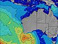 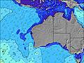 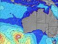 | 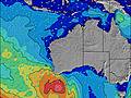 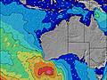 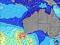 | 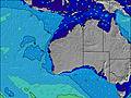 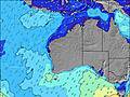 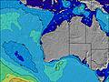 | 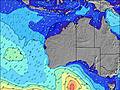 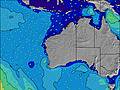 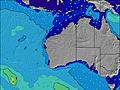 | 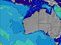 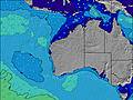 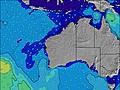 | 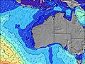   |   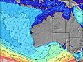 | 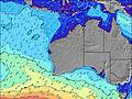 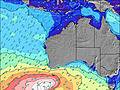 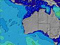 | |||||||||||||||||||||||||||||||||||||||||||||||||||
| Le onde più grandi (m) & direzione (?) | ||||||||||||||||||||||||||||||||||||||||||||||||||||||||||||
| Periodo(s) (?) | 13 | 12 | 12 | 12 | 12 | 18 | 18 | 17 | 16 | 16 | 16 | 15 | 15 | 14 | 14 | 13 | 13 | 13 | 13 | 13 | 14 | 14 | 14 | 14 | 15 | 15 | 15 | 15 | 15 | 15 | 15 | 15 | 15 | 15 | 15 | 15 | 15 | 15 | 15 | 15 | 14 | 14 | 14 | 15 | 16 | 16 | 14 | 14 | 14 | 14 | 14 | 14 | 13 | 13 | 13 | 13 | 13 | 13 | 12 | 12 |
Grafico (?)delle onde | ||||||||||||||||||||||||||||||||||||||||||||||||||||||||||||
| Energia (?) | 514 | 387 | 536 | 399 | 306 | 360 | 486 | 601 | 635 | 666 | 966 | 936 | 857 | 822 | 743 | 634 | 792 | 634 | 624 | 732 | 690 | 626 | 682 | 647 | 784 | 837 | 1083 | 988 | 1052 | 1024 | 1024 | 1024 | 1024 | 1024 | 1117 | 1258 | 1258 | 1177 | 1161 | 1145 | 1114 | 969 | 788 | 1121 | 1107 | 1041 | 789 | 659 | 659 | 569 | 542 | 549 | 402 | 384 | 317 | 378 | 378 | 367 | 246 | 189 |
Vento (km/h) | ||||||||||||||||||||||||||||||||||||||||||||||||||||||||||||
| Stato del vento (?) onshore cross-onshore cross-shore cross-offshore offshore piatto | cross | cross- off | off | off | off | off | glass | cross- on | cross | cross | cross- off | cross- off | cross- off | cross- off | cross- off | cross- off | cross- off | off | off | off | off | off | off | glass | cross | off | off | off | off | cross- off | cross- off | glass | cross | cross- off | off | off | off | cross- off | cross- off | cross- off | off | off | off | cross- off | cross- off | cross- off | cross- off | on | cross- on | cross- off | cross- off | cross- off | cross- off | cross- off | cross- off | glass | cross- on | cross- off | off | cross- off |
Alta Marea / altezza (m) | 8:40AM 0.66 | 8:58AM 0.69 | 9:20AM 0.70 | 9:46AM 0.70 | 10:16AM 0.70 | 10:48AM 0.68 | 11:22AM 0.65 | |||||||||||||||||||||||||||||||||||||||||||||||||||||
Basso Marea / altezza (m) | 4:45PM 0.14 | 5:14PM 0.12 | 5:47PM 0.10 | 6:25PM 0.10 | 7:11PM 0.10 | 8:10PM 0.11 | 9:28PM 0.11 | 10:32PM 0.11 | ||||||||||||||||||||||||||||||||||||||||||||||||||||
Domenica 11 | Lunedì 12 | Martedì 13 | Mercoledì 14 | Giovedì 15 | Venerdì 16 | Sabato 17 | Domenica 18 | Lun 19 | ||||||||||||||||||||||||||||||||||||||||||||||||||||
| Alba | - | - | - | - | - | 6:54 | - | - | - | - | - | - | - | 6:56 | - | - | - | - | - | - | - | 6:56 | - | - | - | - | - | - | - | 6:56 | - | - | - | - | - | - | - | 6:58 | - | - | - | - | - | - | - | 6:58 | - | - | - | - | - | - | - | 6:58 | - | - | - | - | - | - |
| Tramonto | 5:30 | - | - | - | - | - | - | - | 5:30 | - | - | - | - | - | - | - | 5:29 | - | - | - | - | - | - | - | 5:29 | - | - | - | - | - | - | - | 5:28 | - | - | - | - | - | - | - | 5:27 | - | - | - | - | - | - | - | 5:27 | - | - | - | - | - | - | - | 5:25 | - | - | - |
Piog. (mm) | - | - | - | - | - | - | - | - | - | - | - | - | - | - | - | - | - | - | - | - | - | - | - | - | - | - | - | - | - | - | - | - | - | - | - | - | - | - | - | - | - | - | - | - | - | - | - | - | - | - | - | - | - | - | - | - | - | - | - | - |
| Temp. °C | 23 | 22 | 21 | 18 | 17 | 16 | 21 | 20 | 20 | 20 | 19 | 17 | 16 | 16 | 20 | 24 | 25 | 21 | 18 | 17 | 16 | 15 | 20 | 25 | 24 | 23 | 21 | 19 | 18 | 18 | 22 | 24 | 23 | 22 | 21 | 21 | 19 | 18 | 21 | 25 | 25 | 23 | 22 | 20 | 19 | 18 | 22 | 24 | 24 | 22 | 21 | 20 | 19 | 18 | 21 | 24 | 23 | 22 | 21 | 20 |
| Feels °C (?) | 20 | 20 | 19 | 15 | 15 | 14 | 20 | 17 | 17 | 17 | 16 | 14 | 13 | 14 | 17 | 22 | 22 | 17 | 14 | 13 | 12 | 12 | 17 | 24 | 21 | 20 | 17 | 15 | 14 | 14 | 19 | 22 | 19 | 18 | 18 | 17 | 15 | 14 | 17 | 22 | 22 | 18 | 17 | 15 | 14 | 13 | 18 | 21 | 20 | 18 | 17 | 15 | 14 | 13 | 16 | 22 | 19 | 18 | 16 | 15 |
- Map Icons:
 Break
Break Live Wave Height (m)
 Live Wind Speed (km/h)
 Surf Rating (10 Max)
 Ocean Swells (m)
- Wind Speed (km/h)
Widget Free Surf-Forecast.com per il tuo sito
La relazione di surf / widget meteo è disponibile qui sotto per incorporare su siti esterni a titolo gratuito e fornisce una sintesi delle nostre City Beach groyne previsione surf. Basta prendere il frammento di codice html da noi fornito e copiarlo nel proprio sito. È possibile scegliere la lingua preferita e unità metriche / imperiali per il feed delle previsioni surf per soddisfare le esigenze degli utenti del vostro sito .... Clicca qui per ottenere il codice.


 Nearest