
Previsioni:

Previsione a breve terminePioggia abbondante (Totale 37mm), più pesante durante lunedì mattina. Warm (Max 25°C Domenica mattina, Min 23°C martedì mattina). Venti decrescenti (venti freschi da SSW Domenica mattina, calma per lunedì notte). | |||||||||||||||||||||
Dom 2 | Lunedì 3 | Martedì 4 | |||||||||||||||||||
11 AM | 2 PM | 5 PM | 8 PM | 11 PM | 2 AM | 5 AM | 8 AM | 11 AM | 2 PM | 5 PM | 8 PM | 11 PM | 2 AM | 5 AM | 8 AM | 11 AM | 2 PM | 5 PM | 8 PM | 11 PM | |
Mappa dell'altezza del moto ondoso | 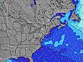 |  |  | 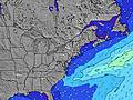 |  |  | 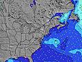 |  | |||||||||||||
Onda Altezza (m) Direzione Periodo (s) | E 6 | SSE 4 | SSE 5 | SSE 5 | S 5 | SSE 7 | S 8 | S 8 | S 8 | S 8 | S 8 | S 8 | S 8 | SSE 7 | E 8 | NE 4 | NE 4 | NE 4 | SE 7 | NE 4 | NE 4 |
Grafico delle onde | |||||||||||||||||||||
1 | 26 | 19 | 28 | 109 | 0 | 0 | 0 | 0 | 0 | 0 | 0 | 0 | 0 | 1 | 17 | 21 | 14 | 41 | 8 | 5 | |
Vento (km/h) | |||||||||||||||||||||
Stato del vento onshore cross-onshore cross-shore cross-offshore offshore piatto | cross-on | cross-on | cross | cross | cross-off | cross-off | cross-off | cross-off | cross-off | cross-off | cross-off | cross-off | off | glassy | cross-on | cross-on | on | cross-on | cross-on | cross-on | cross |
Alta Marea | 10:39AM1.28m | 10:50PM1.36m | 11:19AM1.32m | 11:31PM1.28m | 12:05PM1.36m | ||||||||||||||||
Basso Marea | 4:40PM0.16m | 5:06AM0.05m | 5:28PM0.18m | 5:46AM0.06m | 6:23PM0.20m | ||||||||||||||||
— | — | — | — | — | — | 5:58 | — | — | — | — | — | — | — | 5:58 | — | — | — | — | — | — | |
— | — | — | 8:08 | — | — | — | — | — | — | — | 8:07 | — | — | — | — | — | — | — | 8:07 | — | |
mm | — | — | — | — | 3 | 3 | 2 | 3 | 6 | 3 | 2 | 3 | 3 | 1 | — | — | — | — | — | — | — |
Temp. °C | 25 | 25 | 25 | 25 | 24 | 25 | 24 | 24 | 24 | 25 | 25 | 24 | 24 | 24 | 24 | 23 | 24 | 24 | 24 | 24 | 24 |
Gelo °C | 25 | 26 | 27 | 27 | 25 | 25 | 23 | 23 | 25 | 25 | 25 | 25 | 27 | 28 | 26 | 22 | 24 | 25 | 25 | 25 | 24 |
Onda 1 Altezza (m) Direzione Periodo (s) | S 8 | S 6 | SE 6 | SE 7 | E 5 | — | — | — | — | — | — | — | S 8 | SSE 7 | SSE 7 | SSE 7 | SSE 7 | SSE 7 | S 7 | SSE 7 | SSE 7 |
1 | 7 | 14 | 18 | 1 | — | — | — | — | — | — | — | 287 | 191 | 191 | 160 | 132 | 102 | 60 | 111 | 120 | |
Onda 2 Altezza (m) Direzione Periodo (s) | E 6 | SE 10 | S 6 | E 6 | — | — | — | — | — | — | — | — | — | — | E 8 | — | — | NE 4 | SE 7 | E 8 | NE 4 |
1 | 4 | 3 | 1 | — | — | — | — | — | — | — | — | — | — | 1 | — | — | 14 | 41 | 1 | 5 | |
Onda 3 Altezza (m) Direzione Periodo (s) | E 6 | E 6 | E 5 | — | — | — | — | — | — | — | — | — | — | — | — | — | E 8 | — | — | — | E 9 |
1 | 1 | 1 | — | — | — | — | — | — | — | — | — | — | — | — | — | 1 | — | — | — | 2 | |
onde vento Altezza (m) Direzione Periodo (s) | SSE 6 | SSE 4 | SSE 5 | SSE 5 | S 5 | SSE 7 | S 8 | S 8 | S 8 | S 8 | S 8 | S 8 | — | — | — | NE 4 | NE 4 | NE 4 | NE 4 | NE 4 | — |
55 | 26 | 19 | 28 | 109 | 293 | 510 | 579 | 488 | 481 | 507 | 421 | — | — | — | 17 | 21 | 14 | 11 | 8 | — | |
Il più vicino Offshore or Glassy | |||||||||||||||||||||
Distanza (km) | 1431 | 1270 | 1242 | 1194 | 489 | 1054 | 1001 | 126 | 1227 | 1227 | 101 | 73 | 1 | 1 | 62 | 145 | 168 | 287 | 287 | 287 | 287 |
Migliori previsioni per le condizioni d'onda in New Jersey | |||||||||||||||||||||
Migliori previsioni per le condizioni d'onda in United States | |||||||||||||||||||||
Trova Onde Globale | |||||||||||||||||||||
- Map Icons:
 Break
Break Live Wave Height (m)
 Live Wind Speed (km/h)
 Surf Rating (10 Max)
 Ocean Swells (m)
- Wind Speed (km/h)
Widget Free Surf-Forecast.com per il tuo sito
La relazione di surf / widget meteo è disponibile qui sotto per incorporare su siti esterni a titolo gratuito e fornisce una sintesi delle nostre Crystals previsione surf. Basta prendere il frammento di codice html da noi fornito e copiarlo nel proprio sito. È possibile scegliere la lingua preferita e unità metriche / imperiali per il feed delle previsioni surf per soddisfare le esigenze degli utenti del vostro sito .... Clicca qui per ottenere il codice.
 Nearest