
Previsioni:

Previsione a breve termineper lo più asciutto. Warm (Max 27°C mercoledì mattina, Min 26°C mercoledì notte). Principalmente venti freschi. | ||||||||||||||||||||||||
Mercoledì 15 | Giovedì 16 | Venerdì 17 | 18 | |||||||||||||||||||||
5 AM | 8 AM | 11 AM | 2 PM | 5 PM | 8 PM | 11 PM | 2 AM | 5 AM | 8 AM | 11 AM | 2 PM | 5 PM | 8 PM | 11 PM | 2 AM | 5 AM | 8 AM | 11 AM | 2 PM | 5 PM | 8 PM | 11 PM | 2 AM | |
Mappa dell'altezza del moto ondoso |  |  | 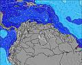 |  | 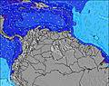 | 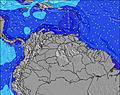 |  | 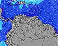 | 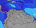 | 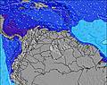 | ||||||||||||||
Onda Altezza (m) Direzione Periodo (s) | N 10 | N 10 | N 9 | NNW 8 | N 9 | N 9 | N 9 | N 9 | N 9 | N 9 | N 8 | N 8 | N 8 | N 8 | N 7 | N 7 | N 7 | N 7 | NNE 8 | NNE 7 | NNE 8 | NNE 8 | NNE 8 | NNE 8 |
Grafico delle onde | ||||||||||||||||||||||||
7 | 2 | 3 | 6 | 2 | 2 | 2 | 2 | 2 | 2 | 5 | 5 | 5 | 10 | 9 | 9 | 8 | 8 | 7 | 9 | 13 | 12 | 11 | 11 | |
Vento (km/h) | ||||||||||||||||||||||||
Stato del vento onshore cross-onshore cross-shore cross-offshore offshore piatto | cross-off | cross-off | cross-off | cross-off | cross-off | cross-off | cross-off | cross-off | cross-off | cross-off | cross-off | cross-off | cross-off | cross-off | cross-off | cross-off | cross-off | cross-off | cross-off | cross-off | cross-off | cross-off | cross-off | cross-off |
Alta Marea | 5:42AM0.23m | 9:56PM0.41m | 7:49AM0.24m | 10:35PM0.39m | 9:34AM0.25m | 11:08PM0.36m | ||||||||||||||||||
Basso Marea | 4:34AM0.23m | 1:46PM-0.00m | 4:34AM0.22m | 2:43PM0.04m | 4:56AM0.20m | 3:40PM0.09m | ||||||||||||||||||
5:45 | — | — | — | — | — | — | — | 5:45 | — | — | — | — | — | — | — | 5:45 | — | — | — | — | — | — | 5:46 | |
— | — | — | — | 6:51 | — | — | — | — | — | — | — | 6:51 | — | — | — | — | — | — | — | 6:51 | — | — | 6:51 | |
mm | — | — | — | — | — | — | — | — | — | — | — | — | — | — | — | — | — | — | — | — | — | — | — | — |
Temp. °C | 27 | 27 | 27 | 27 | 27 | 26 | 26 | 26 | 26 | 26 | 26 | 26 | 26 | 26 | 26 | 26 | 26 | 26 | 26 | 27 | 26 | 26 | 26 | 26 |
Gelo °C | 26 | 26 | 26 | 26 | 26 | 25 | 25 | 25 | 25 | 25 | 25 | 25 | 25 | 25 | 25 | 25 | 25 | 26 | 25 | 26 | 25 | 25 | 25 | 25 |
Onda 1 Altezza (m) Direzione Periodo (s) | N 10 | N 10 | N 9 | NNW 8 | NW 8 | NW 7 | NW 7 | NW 7 | NW 7 | N 8 | N 8 | N 8 | N 8 | N 8 | N 7 | N 7 | N 7 | N 7 | NNE 8 | NNE 7 | NNE 8 | NNE 8 | NNE 8 | NNE 8 |
7 | 2 | 2 | 6 | 2 | 2 | 2 | 2 | 2 | 1 | 5 | 5 | 5 | 10 | 9 | 9 | 8 | 8 | 7 | 9 | 13 | 12 | 11 | 11 | |
Onda 2 Altezza (m) Direzione Periodo (s) | NW 8 | NW 8 | NW 8 | N 9 | N 9 | N 9 | N 9 | N 9 | N 8 | NW 7 | NW 7 | NW 6 | NW 6 | NW 6 | N 6 | N 6 | N 6 | NNE 9 | N 7 | — | NE 10 | NE 10 | NE 10 | NNE 9 |
2 | 2 | 3 | 2 | 2 | 2 | 2 | 2 | 1 | 2 | 2 | 2 | 2 | 1 | 1 | 1 | 1 | 7 | 4 | — | 4 | 4 | 4 | 8 | |
Onda 3 Altezza (m) Direzione Periodo (s) | N 6 | N 6 | N 6 | N 9 | N 5 | E 13 | N 9 | N 9 | N 9 | N 9 | — | N 9 | — | — | — | — | E 13 | NE 10 | N 7 | — | — | N 8 | NE 8 | NE 10 |
1 | 1 | 1 | 2 | 1 | 4 | 2 | 2 | 2 | 2 | — | 2 | — | — | — | — | 3 | 4 | 1 | — | — | 1 | 2 | 4 | |
onde vento Altezza (m) Direzione Periodo (s) | E 7 | E 7 | E 7 | E 7 | E 7 | E 7 | E 7 | E 7 | E 7 | E 6 | E 7 | E 7 | E 7 | E 7 | E 7 | E 7 | E 7 | E 7 | E 7 | E 7 | E 7 | E 7 | E 7 | E 7 |
155 | 130 | 107 | 107 | 108 | 108 | 127 | 152 | 150 | 123 | 144 | 131 | 131 | 113 | 143 | 139 | 153 | 131 | 135 | 149 | 149 | 154 | 154 | 168 | |
Il più vicino Offshore or Glassy | ||||||||||||||||||||||||
Distanza (km) | 155 | 38 | 38 | 38 | 248 | 248 | 248 | 646 | 646 | 750 | 925 | 925 | 155 | 677 | 683 | 330 | 248 | 372 | 925 | 298 | 683 | 248 | 248 | 719 |
Migliori previsioni per le condizioni d'onda in Netherlands-Antilles - Saint Martin | ||||||||||||||||||||||||
Migliori previsioni per le condizioni d'onda in Netherlands Antilles | ||||||||||||||||||||||||
Trova Onde Globale | ||||||||||||||||||||||||
- Map Icons:
 Break
Break Live Wave Height (m)
 Live Wind Speed (km/h)
 Surf Rating (10 Max)
 Ocean Swells (m)
- Wind Speed (km/h)
Widget Free Surf-Forecast.com per il tuo sito
La relazione di surf / widget meteo è disponibile qui sotto per incorporare su siti esterni a titolo gratuito e fornisce una sintesi delle nostre Cupecoy previsione surf. Basta prendere il frammento di codice html da noi fornito e copiarlo nel proprio sito. È possibile scegliere la lingua preferita e unità metriche / imperiali per il feed delle previsioni surf per soddisfare le esigenze degli utenti del vostro sito .... Clicca qui per ottenere il codice.
 Nearest