
Previsioni:

Previsione a breve terminepioggia leggera (Totale 3mm), per lo più che cade Sabato notte. Warm (Max 23°C giovedì notte, Min 17°C giovedì notte). Principalmente venti freschi. | |||||||||||||||||||
Gio 16 | Venerdì 17 | Sabato 18 | |||||||||||||||||
5 PM | 8 PM | 11 PM | 2 AM | 5 AM | 8 AM | 11 AM | 2 PM | 5 PM | 8 PM | 11 PM | 2 AM | 5 AM | 8 AM | 11 AM | 2 PM | 5 PM | 8 PM | 11 PM | |
Mappa dell'altezza del moto ondoso | 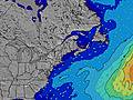 | 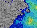 | 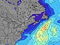 | 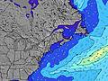 | 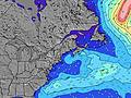 | 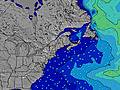 | 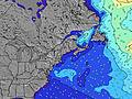 | ||||||||||||
Onda Altezza (m) Direzione Periodo (s) | SSE 5 | SE 15 | SE 15 | SSE 6 | SSE 6 | SE 15 | SE 14 | SE 14 | S 15 | SE 14 | SE 14 | SE 14 | SE 14 | SE 14 | SE 14 | SSE 4 | S 6 | S 7 | S 7 |
Grafico delle onde | |||||||||||||||||||
3 | 9 | 9 | 10 | 10 | 9 | 8 | 8 | 8 | 8 | 8 | 8 | 8 | 8 | 7 | 15 | 183 | 480 | 466 | |
Vento (km/h) | |||||||||||||||||||
Stato del vento onshore cross-onshore cross-shore cross-offshore offshore piatto | off | off | off | cross-off | cross-off | off | off | cross-on | cross-on | cross | cross-off | off | off | glassy | cross-on | cross-on | cross-on | cross | cross |
Alta Marea | 1:34AM3.34m | 2:14PM3.01m | 2:28AM3.20m | 3:06PM2.99m | |||||||||||||||
Basso Marea | 7:18PM-0.06m | 7:57AM-0.34m | 8:14PM-0.03m | 8:47AM-0.22m | 9:09PM0.03m | ||||||||||||||
— | — | — | — | 5:13 | — | — | — | — | — | — | — | 5:15 | — | — | — | — | — | — | |
— | 8:19 | — | — | — | — | — | — | — | 8:17 | — | — | — | — | — | — | — | 8:16 | — | |
mm | — | — | — | — | — | — | — | — | — | — | — | — | — | — | — | — | — | 1 | 1 |
Temp. °C | 25 | 23 | 20 | 18 | 17 | 18 | 22 | 22 | 23 | 22 | 21 | 21 | 19 | 18 | 20 | 23 | 23 | 21 | 19 |
Gelo °C | 21 | 21 | 17 | 15 | 13 | 14 | 19 | 19 | 20 | 19 | 19 | 19 | 17 | 16 | 17 | 19 | 19 | 18 | 16 |
Onda 1 Altezza (m) Direzione Periodo (s) | SSW 4 | S 5 | SSE 5 | SSE 6 | SSE 6 | SSE 5 | S 5 | S 5 | SE 14 | SSE 2 | SE 14 | S 3 | S 4 | SSE 4 | SE 14 | SE 13 | SE 13 | SE 13 | SE 13 |
1 | 4 | 5 | 10 | 10 | 6 | 2 | 2 | 8 | 1 | 8 | 1 | 3 | 3 | 7 | 7 | 7 | 7 | 7 | |
Onda 2 Altezza (m) Direzione Periodo (s) | SSE 5 | SE 9 | SE 9 | SE 15 | SE 15 | SE 15 | SE 14 | SE 14 | SE 9 | SE 14 | — | SE 14 | SE 14 | SE 14 | SE 8 | SE 8 | — | SE 13 | SE 13 |
3 | 3 | 3 | 9 | 9 | 9 | 8 | 8 | 3 | 8 | — | 8 | 8 | 8 | 3 | 3 | — | 7 | 7 | |
Onda 3 Altezza (m) Direzione Periodo (s) | SE 9 | SE 15 | SE 15 | SE 9 | SE 9 | SE 9 | — | SE 9 | S 15 | SE 8 | SE 8 | SE 8 | SE 8 | SE 8 | S 6 | SE 14 | — | — | — |
3 | 9 | 9 | 3 | 3 | 3 | — | 3 | 4 | 3 | 3 | 3 | 3 | 3 | 1 | 8 | — | — | — | |
onde vento Altezza (m) Direzione Periodo (s) | WNW 3 | NW 3 | NW 3 | WNW 2 | — | W 2 | — | — | S 5 | S 3 | — | — | — | — | SSE 4 | SSE 4 | S 6 | S 7 | S 7 |
3 | 4 | 2 | 1 | — | 1 | — | — | 2 | 1 | — | — | — | — | 3 | 15 | 183 | 480 | 466 | |
Il più vicino Offshore or Glassy | |||||||||||||||||||
Distanza (km) | 844 | 371 | 328 | 844 | 843 | 443 | 445 | 436 | 436 | 466 | 443 | 445 | 844 | 443 | 3678 | 2884 | 1823 | 612 | 515 |
Migliori previsioni per le condizioni d'onda in Maine | |||||||||||||||||||
Migliori previsioni per le condizioni d'onda in United States | |||||||||||||||||||
Trova Onde Globale | |||||||||||||||||||
- Map Icons:
 Break
Break Live Wave Height (m)
 Live Wind Speed (km/h)
 Surf Rating (10 Max)
 Ocean Swells (m)
- Wind Speed (km/h)
Widget Free Surf-Forecast.com per il tuo sito
La relazione di surf / widget meteo è disponibile qui sotto per incorporare su siti esterni a titolo gratuito e fornisce una sintesi delle nostre Doc Browns previsione surf. Basta prendere il frammento di codice html da noi fornito e copiarlo nel proprio sito. È possibile scegliere la lingua preferita e unità metriche / imperiali per il feed delle previsioni surf per soddisfare le esigenze degli utenti del vostro sito .... Clicca qui per ottenere il codice.
 Nearest