
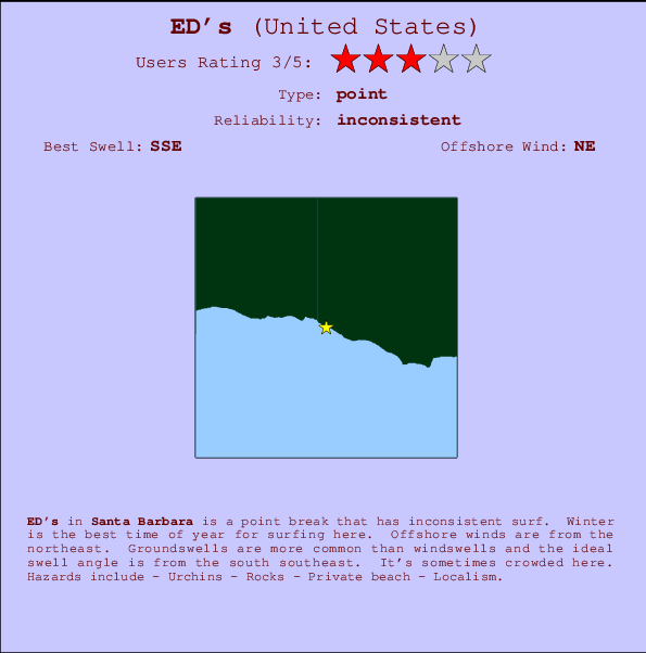
ED's Surf Guide
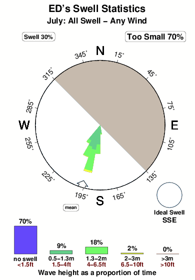
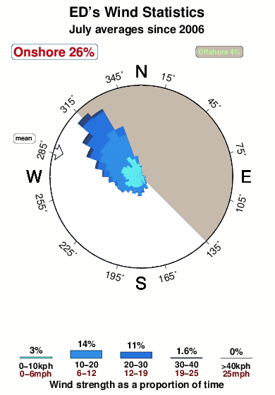
ED's in Santa Barbara is a fairly exposed point break that does not work very often. Winter is the optimum time of year for surfing here. Offshore winds blow from the northeast. Tends to receive distant groundswells and the ideal swell direction is from the south southeast. When the surf is up, it can get quite busy in the water. Hazards include - Urchins - Rocks - Private beach - Localism.
ED's Spot Info
| Type: | Rating: | Reliability: | Todays Sea Temp*: |
|---|---|---|---|
| inconsistent | 18.0°C*ocean temperature recorded from satellite |
Surfing ED's:
The best conditions reported for surf at ED's occur when a South-southeast swell combines with an offshore wind direction from the Northeast.

Previsioni Energia d'onda (Potenza): 12hrs


ED's Surf:
Tuesday, 14 July 2026, 06:46 Local time| Martedì 14 | ||||
| 2AM | 5AM | 8AM | 11AM | |
| Wave (m) | ||||
| Periodo (s) | 13 | 13 | 12 | 13 |
| Vento (km/h) | ||||
| Stato del vento | glass | glass | glass | on |
- /breaks/ED-s/forecasts/latest
ED's Surf Guide
ED's in Santa Barbara is a fairly exposed point break that does not work very often. Winter is the optimum time of year for surfing here. Offshore winds blow from the northeast. Tends to receive distant groundswells and the ideal swell direction is from the south southeast. When the surf is up, it can get quite busy in the water. Hazards include - Urchins - Rocks - Private beach - Localism.
ED's Spot Info
Type: Rating: Reliability: Todays Sea Temp*:  Point
Point 3
3inconsistent 18.0°C*ocean temperature recorded from satelliteSurfing ED's:
The best conditions reported for surf at ED's occur when a South-southeast swell combines with an offshore wind direction from the Northeast.
Previsioni Energia d'onda (Potenza): 12hrs
Utilizzare la scheda di navigazione in alto per visualizzare ED's temperatura del mare, ED's fotografie, ED's dettagliate previsioni onde, il vento e le previsioni meteo, ED's webcam, vento corrente da CAL - Santa Barbara stazioni meteo e ED's previsioni marea. Il link United States mappe maree apre l'immagine grande, che mostra United States e dei mari circostanti. Queste mappe possono essere animate per mostrare le diverse componenti del moto ondoso, energia delle onde, periodo d'onda, altezza delle onde, insieme con le previsioni del vento e meteo, meteo corrente e osservazioni sullo stato del mare dal United States onda-boe, le navi passanti e stazioni meteo costiere. Ciascuna delle pagine di previsioni per questo surf break rappresenta uno strumento di wavefinder globale e regionale per individuare le migliori condizioni di surf nella zona intorno ED's.
ED's Surf:
Tuesday, 14 July 2026, 06:46 Local timeMartedì 14 2AM 5AM 8AM 11AM Wave (m) Periodo (s) 13 13 12 13 Vento (km/h) Stato del vento glass glass glass on - /breaks/ED-s/forecasts/latest
- /breaks/ED-s/forecasts/latest/six_day
ED's Surf Guide
ED's in Santa Barbara is a fairly exposed point break that does not work very often. Winter is the optimum time of year for surfing here. Offshore winds blow from the northeast. Tends to receive distant groundswells and the ideal swell direction is from the south southeast. When the surf is up, it can get quite busy in the water. Hazards include - Urchins - Rocks - Private beach - Localism.
ED's Spot Info
Type: Rating: Reliability: Todays Sea Temp*: Point3inconsistent 18.0°C*ocean temperature recorded from satelliteSurfing ED's:
The best conditions reported for surf at ED's occur when a South-southeast swell combines with an offshore wind direction from the Northeast.
Previsioni Energia d'onda (Potenza): 12hrs
Utilizzare la scheda di navigazione in alto per visualizzare ED's temperatura del mare, ED's fotografie, ED's dettagliate previsioni onde, il vento e le previsioni meteo, ED's webcam, vento corrente da CAL - Santa Barbara stazioni meteo e ED's previsioni marea. Il link United States mappe maree apre l'immagine grande, che mostra United States e dei mari circostanti. Queste mappe possono essere animate per mostrare le diverse componenti del moto ondoso, energia delle onde, periodo d'onda, altezza delle onde, insieme con le previsioni del vento e meteo, meteo corrente e osservazioni sullo stato del mare dal United States onda-boe, le navi passanti e stazioni meteo costiere. Ciascuna delle pagine di previsioni per questo surf break rappresenta uno strumento di wavefinder globale e regionale per individuare le migliori condizioni di surf nella zona intorno ED's.
ED's Surf:
Tuesday, 14 July 2026, 06:46 Local timeMartedì 14 2AM 5AM 8AM 11AM Wave (m) Periodo (s) 13 13 12 13 Vento (km/h) Stato del vento glass glass glass on - /breaks/ED-s/forecasts/latest
ED's Surf Guide
ED's in Santa Barbara is a fairly exposed point break that does not work very often. Winter is the optimum time of year for surfing here. Offshore winds blow from the northeast. Tends to receive distant groundswells and the ideal swell direction is from the south southeast. When the surf is up, it can get quite busy in the water. Hazards include - Urchins - Rocks - Private beach - Localism.
ED's Spot Info
Type: Rating: Reliability: Todays Sea Temp*: Point3inconsistent 18.0°C*ocean temperature recorded from satelliteSurfing ED's:
The best conditions reported for surf at ED's occur when a South-southeast swell combines with an offshore wind direction from the Northeast.
Previsioni Energia d'onda (Potenza): 12hrs
Utilizzare la scheda di navigazione in alto per visualizzare ED's temperatura del mare, ED's fotografie, ED's dettagliate previsioni onde, il vento e le previsioni meteo, ED's webcam, vento corrente da CAL - Santa Barbara stazioni meteo e ED's previsioni marea. Il link United States mappe maree apre l'immagine grande, che mostra United States e dei mari circostanti. Queste mappe possono essere animate per mostrare le diverse componenti del moto ondoso, energia delle onde, periodo d'onda, altezza delle onde, insieme con le previsioni del vento e meteo, meteo corrente e osservazioni sullo stato del mare dal United States onda-boe, le navi passanti e stazioni meteo costiere. Ciascuna delle pagine di previsioni per questo surf break rappresenta uno strumento di wavefinder globale e regionale per individuare le migliori condizioni di surf nella zona intorno ED's.
ED's Surf:
Tuesday, 14 July 2026, 06:46 Local timeMartedì 14 2AM 5AM 8AM 11AM Wave (m) Periodo (s) 13 13 12 13 Vento (km/h) Stato del vento glass glass glass on Tide Times:
Per Beavers, %{dist} %{km} da %{location}.
PROSSIMA È ALLE (ora locale) rimanente alta marea bassa marea ED's Tide Times and Tide Chart
Live Weather:
At Santa Barbara Airport, 13 km from ED's.
calm
(km/h)
Dry and partly cloudyAir temperature
17.2°CBuoy Data:
At East Santa Barbara Buoy, 16 miles from ED's.
9PM 10PM 11PM 12AM Attualità dei dati 8 hr 7 hr 6 hr 5 hr Altezza delle onde (m) 


Overall ED's Surf Consistency and Wind Distribution in Luglio
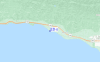
foto dall' album
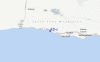
Contorni: Strade e fiumi: seleziona un surf break dal menu 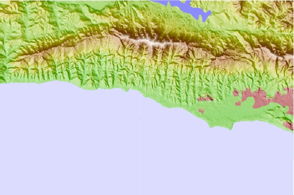
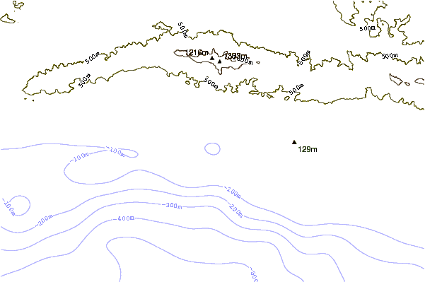
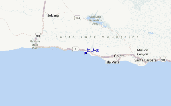
Utilizzare questa mappa sollievo per navigare CAL - Santa Barbara surf breaks e stazioni di marea che si trovano nella zona diED's
Altri surf breaks più vicini al ED's:
(clicca sul nome del luogo per maggiori informazioni)- Closest località surf2 mi
- Second closest località surf2 mi
- Third closest località surf4 mi
- Fourth closest località surf4 mi
- Fifth closest località surf5 mi
Onda boe più vicina a ED's:
- Closest Onda boa16 mi
- Second closest Onda boa30 mi
- Third closest Onda boa37 mi
- Fourth closest Onda boa45 mi
- Fifth closest Onda boa54 mi
Stazioni di marea più vicina alla ED's:
- Closest marea stazioneIsla Vista7 mi
- Second closest marea stazioneGoleta9 mi
- Third closest marea stazioneGaviota13 mi
- Fourth closest marea stazioneSanta Barbara17 mi
- Fifth closest marea stazioneMontecito21 mi
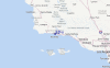
Airports
- The closest passenger airport to ED's is Vandenberg Afb (Lompoc) Airport (VBG) in USA, 62 km (39 miles) away (directly).
- The second nearest airport to ED's is Point Mugu Nas Airport (NTD), also in USA, 88 km (55 miles) away.
- Third is Meadows Fld (Bakersfield) Airport (BFL) in USA, 139 km (86 miles) away.
- Burbank Glendale Pasadena Airport (BUR) in USA is 152 km (94 miles) away.
- Los Angeles International Airport (LAX), also in USA is the fifth nearest airport to ED's and is 156 km (97 miles) away.
- /breaks/ED-s/forecasts/latest


 Nearest