
Previsioni:

Previsione a breve terminePioggia abbondante (Totale 22mm), più pesante durante sabato mattina. Warm (Max 28°C Sabato mattina, Min 27°C Sabato pomeriggio). Principalmente venti freschi. | |||||||||||||||||||||
25 | Domenica 26 | Lunedì 27 | |||||||||||||||||||
9 AM | 12 PM | 3 PM | 6 PM | 9 PM | 12 AM | 3 AM | 6 AM | 9 AM | 12 PM | 3 PM | 6 PM | 9 PM | 12 AM | 3 AM | 6 AM | 9 AM | 12 PM | 3 PM | 6 PM | 9 PM | |
Mappa dell'altezza del moto ondoso |  |  |  | 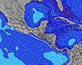 |  |  | 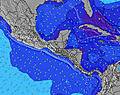 |  | |||||||||||||
Onda Altezza (m) Direzione Periodo (s) | E 6 | E 6 | E 5 | E 6 | E 7 | E 7 | E 7 | E 7 | E 6 | E 6 | E 6 | E 6 | E 6 | E 6 | E 6 | E 6 | E 6 | ESE 6 | E 6 | E 6 | E 4 |
Grafico delle onde | |||||||||||||||||||||
50 | 39 | 46 | 144 | 262 | 330 | 243 | 199 | 139 | 127 | 80 | 68 | 89 | 101 | 105 | 98 | 81 | 62 | 54 | 50 | 31 | |
Vento (km/h) | |||||||||||||||||||||
Stato del vento onshore cross-onshore cross-shore cross-offshore offshore piatto | on | on | on | on | on | on | on | on | on | on | on | on | on | on | on | on | on | on | on | on | on |
Alta Marea | 7:10PM0.17m | 6:28AM0.19m | 7:37PM0.17m | 7:02AM0.19m | 8:02PM0.18m | ||||||||||||||||
Basso Marea | 12:39PM0.03m | 00:40AM0.09m | 1:09PM0.03m | 1:07AM0.09m | 1:38PM0.03m | ||||||||||||||||
5:28 | — | — | — | — | — | 5:28 | — | — | — | — | — | — | — | 5:28 | — | — | — | — | — | — | |
— | — | — | 6:28 | — | — | — | — | — | — | — | 6:28 | — | — | — | — | — | — | — | 6:27 | — | |
mm | 2 | 6 | 4 | 3 | 1 | — | — | — | 3 | 3 | — | — | — | — | — | — | — | — | — | — | — |
Temp. °C | 28 | 28 | 27 | 27 | 28 | 28 | 28 | 28 | 27 | 28 | 28 | 28 | 28 | 28 | 28 | 28 | 28 | 28 | 28 | 28 | 28 |
Gelo °C | 30 | 28 | 26 | 26 | 25 | 26 | 26 | 28 | 26 | 28 | 29 | 28 | 28 | 28 | 28 | 29 | 30 | 30 | 29 | 29 | 29 |
Onda 1 Altezza (m) Direzione Periodo (s) | E 8 | E 8 | N 6 | — | — | — | — | — | — | — | E 8 | E 8 | — | — | E 9 | E 8 | E 8 | E 8 | E 8 | E 8 | — |
10 | 10 | 1 | — | — | — | — | — | — | — | 22 | 22 | — | — | 14 | 13 | 12 | 21 | 12 | 12 | — | |
Onda 2 Altezza (m) Direzione Periodo (s) | N 6 | — | — | — | — | — | — | — | — | — | — | — | — | — | — | — | — | — | — | — | — |
1 | — | — | — | — | — | — | — | — | — | — | — | — | — | — | — | — | — | — | — | — | |
Onda 3 Altezza (m) Direzione Periodo (s) | — | — | — | — | — | — | — | — | — | — | — | — | — | — | — | — | — | — | — | — | — |
— | — | — | — | — | — | — | — | — | — | — | — | — | — | — | — | — | — | — | — | — | |
onde vento Altezza (m) Direzione Periodo (s) | E 6 | E 6 | E 5 | E 6 | E 7 | E 7 | E 7 | E 7 | E 6 | E 6 | E 6 | E 6 | E 6 | E 6 | E 6 | E 6 | E 6 | ESE 6 | E 6 | E 6 | E 4 |
50 | 39 | 46 | 144 | 262 | 330 | 243 | 199 | 139 | 127 | 80 | 68 | 89 | 101 | 105 | 98 | 81 | 62 | 54 | 50 | 31 | |
Il più vicino Offshore or Glassy | |||||||||||||||||||||
Distanza (km) | 478 | 542 | 788 | 258 | 258 | 478 | 478 | 478 | 478 | 649 | 649 | 480 | 484 | 258 | 478 | 478 | 478 | 501 | 643 | 617 | 480 |
Migliori previsioni per le condizioni d'onda in Belize | |||||||||||||||||||||
Migliori previsioni per le condizioni d'onda in Belize | |||||||||||||||||||||
Trova Onde Globale | |||||||||||||||||||||
- Map Icons:
 Break
Break Live Wave Height (m)
 Live Wind Speed (km/h)
 Surf Rating (10 Max)
 Ocean Swells (m)
- Wind Speed (km/h)
Widget Free Surf-Forecast.com per il tuo sito
La relazione di surf / widget meteo è disponibile qui sotto per incorporare su siti esterni a titolo gratuito e fornisce una sintesi delle nostre East Point Long Cay previsione surf. Basta prendere il frammento di codice html da noi fornito e copiarlo nel proprio sito. È possibile scegliere la lingua preferita e unità metriche / imperiali per il feed delle previsioni surf per soddisfare le esigenze degli utenti del vostro sito .... Clicca qui per ottenere il codice.
 Nearest