
Previsioni:

Previsione a breve termineper lo più asciutto. Very mild (Max 17°C Venerdì pomeriggio, Min 12°C Sabato pomeriggio). Vento sarà generalmente leggero. | ||||||||||||||||||||||||
Mer 8 | Giovedì 9 | Venerdì 10 | 11 | |||||||||||||||||||||
5 PM | 8 PM | 11 PM | 2 AM | 5 AM | 8 AM | 11 AM | 2 PM | 5 PM | 8 PM | 11 PM | 2 AM | 5 AM | 8 AM | 11 AM | 2 PM | 5 PM | 8 PM | 11 PM | 2 AM | 5 AM | 8 AM | 11 AM | 2 PM | |
Mappa dell'altezza del moto ondoso |  |  | 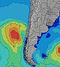 |  |  | 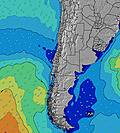 |  |  | 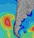 | |||||||||||||||
Onda Altezza (m) Direzione Periodo (s) | W 11 | SW 14 | SW 14 | WSW 12 | W 12 | W 12 | W 12 | W 11 | W 11 | W 11 | SW 14 | SW 14 | SW 14 | W 11 | W 11 | W 11 | W 11 | W 11 | W 11 | WSW 11 | WSW 11 | W 10 | WSW 10 | WSW 10 |
Grafico delle onde | ||||||||||||||||||||||||
483 | 528 | 1170 | 1498 | 956 | 925 | 786 | 663 | 655 | 576 | 576 | 493 | 408 | 401 | 342 | 342 | 287 | 282 | 279 | 400 | 541 | 506 | 410 | 394 | |
Vento (km/h) | ||||||||||||||||||||||||
Stato del vento onshore cross-onshore cross-shore cross-offshore offshore piatto | cross-off | cross-off | off | off | cross-off | cross-off | cross-off | cross-off | off | cross-off | cross-off | cross-off | glassy | glassy | glassy | cross | cross-off | off | cross-off | cross-off | cross-off | cross-off | cross-off | cross-off |
Alta Marea | 4:05PM0.94m | 5:15AM1.11m | 5:19PM0.87m | 6:19AM1.21m | 6:41PM0.83m | 7:21AM1.33m | ||||||||||||||||||
Basso Marea | 10:30PM0.29m | 11:48AM0.43m | 11:27PM0.29m | 1:09PM0.34m | 00:29AM0.28m | |||||||||||||||||||
— | — | — | — | 7:50 | — | — | — | — | — | — | — | 7:50 | — | — | — | — | — | — | — | 7:48 | — | — | — | |
5:52 | — | — | — | — | — | — | — | 5:53 | — | — | — | — | — | — | — | 5:53 | — | — | — | — | — | — | 5:54 | |
mm | — | — | — | — | — | — | — | — | — | — | — | — | — | — | — | — | — | — | — | — | — | — | — | — |
Temp. °C | 15 | 15 | 16 | 15 | 15 | 15 | 16 | 16 | 15 | 15 | 15 | 14 | 15 | 15 | 16 | 17 | 17 | 16 | 15 | 14 | 14 | 13 | 14 | 14 |
Gelo °C | 12 | 12 | 12 | 10 | 10 | 11 | 12 | 12 | 13 | 13 | 14 | 13 | 14 | 15 | 15 | 15 | 16 | 15 | 13 | 12 | 13 | 11 | 11 | 10 |
Onda 1 Altezza (m) Direzione Periodo (s) | W 11 | W 11 | SW 14 | WSW 12 | W 12 | W 12 | W 12 | W 11 | W 11 | W 11 | W 11 | W 11 | W 11 | W 11 | W 11 | W 11 | W 11 | W 11 | W 11 | WSW 11 | WSW 11 | W 10 | WSW 10 | WSW 10 |
483 | 466 | 1170 | 1498 | 956 | 925 | 786 | 663 | 655 | 576 | 576 | 493 | 408 | 401 | 342 | 342 | 287 | 282 | 279 | 400 | 541 | 506 | 410 | 394 | |
Onda 2 Altezza (m) Direzione Periodo (s) | SW 14 | SW 14 | W 11 | SW 13 | SW 13 | SW 13 | SW 13 | SW 13 | SW 13 | SW 13 | SW 14 | SW 14 | SW 14 | SW 13 | SW 13 | SW 13 | SW 13 | SW 13 | SW 13 | SW 13 | SW 13 | SW 13 | SW 13 | SW 14 |
404 | 528 | 389 | 215 | 690 | 545 | 633 | 600 | 386 | 398 | 518 | 471 | 404 | 347 | 342 | 253 | 205 | 205 | 199 | 196 | 202 | 245 | 212 | 234 | |
Onda 3 Altezza (m) Direzione Periodo (s) | — | — | — | — | — | — | — | — | SW 10 | SW 10 | — | — | — | — | — | — | — | — | — | — | — | — | — | — |
— | — | — | — | — | — | — | — | 117 | 77 | — | — | — | — | — | — | — | — | — | — | — | — | — | — | |
onde vento Altezza (m) Direzione Periodo (s) | — | — | — | — | — | — | — | — | — | — | — | — | — | — | — | — | — | — | — | — | — | — | — | — |
— | — | — | — | — | — | — | — | — | — | — | — | — | — | — | — | — | — | — | — | — | — | — | — | |
Il più vicino Offshore or Glassy | ||||||||||||||||||||||||
Distanza (km) | 0 | 0 | 0 | 0 | 0 | 0 | 0 | 0 | 0 | 0 | 0 | 0 | 0 | 0 | 0 | 6 | 0 | 0 | 0 | 0 | 0 | 0 | 6 | 315 |
Migliori previsioni per le condizioni d'onda in Santiago | ||||||||||||||||||||||||
Migliori previsioni per le condizioni d'onda in Chile | ||||||||||||||||||||||||
Trova Onde Globale | ||||||||||||||||||||||||
- Map Icons:
 Break
Break Live Wave Height (m)
 Live Wind Speed (km/h)
 Surf Rating (10 Max)
 Ocean Swells (m)
- Wind Speed (km/h)
Widget Free Surf-Forecast.com per il tuo sito
La relazione di surf / widget meteo è disponibile qui sotto per incorporare su siti esterni a titolo gratuito e fornisce una sintesi delle nostre El Quisco Point previsione surf. Basta prendere il frammento di codice html da noi fornito e copiarlo nel proprio sito. È possibile scegliere la lingua preferita e unità metriche / imperiali per il feed delle previsioni surf per soddisfare le esigenze degli utenti del vostro sito .... Clicca qui per ottenere il codice.
 Nearest