

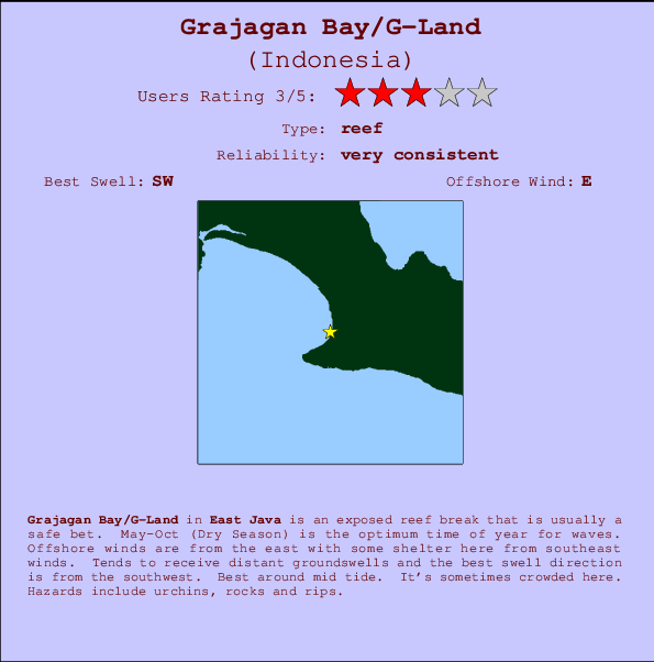
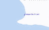
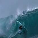
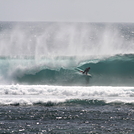
Grajagan Bay/G-Land Surf Guide
Grajagan Bay/G-Land in East Java is an exposed reef break that has very consistent waves. May-Oct (Dry Season) is the optimum time of year for waves. Offshore winds are from the east with some shelter here from southeast winds. Most of the surf here comes from groundswells and the best swell direction is from the southwest. A left hand reef break. Best around mid tide. When it's working here, it can get crowded. Beware of urchins, rocks and rips.
Grajagan Bay/G-Land Spot Info
| Type: | Rating: | Reliability: | Todays Sea Temp*: |
|---|---|---|---|
| very consistent | 26.1°C*ocean temperature recorded from satellite |
Surfing Grajagan Bay/G-Land:
The best conditions reported for surf at Grajagan Bay/G-Land occur when a Southwest swell combines with an offshore wind direction from the East.

Previsioni Energia d'onda (Potenza): 12hrs


Grajagan Bay/G-Land Surf:
Thursday, 16 July 2026, 08:53 Local time| Giovedì 16 | ||||
| 4AM | 7AM | 10AM | 1PM | |
| Wave (m) | ||||
| Periodo (s) | 15 | 15 | 15 | 15 |
| Vento (km/h) | ||||
| Stato del vento | off | off | cross- off |
cross- off |
- /breaks/Grajagan-Bay/forecasts/latest
Grajagan Bay/G-Land Surf Guide
Grajagan Bay/G-Land in East Java is an exposed reef break that has very consistent waves. May-Oct (Dry Season) is the optimum time of year for waves. Offshore winds are from the east with some shelter here from southeast winds. Most of the surf here comes from groundswells and the best swell direction is from the southwest. A left hand reef break. Best around mid tide. When it's working here, it can get crowded. Beware of urchins, rocks and rips.
Grajagan Bay/G-Land Spot Info
Type: Rating: Reliability: Todays Sea Temp*:  Reef
Reef 3
3very consistent 26.1°C*ocean temperature recorded from satelliteSurfing Grajagan Bay/G-Land:
The best conditions reported for surf at Grajagan Bay/G-Land occur when a Southwest swell combines with an offshore wind direction from the East.
Previsioni Energia d'onda (Potenza): 12hrs
Utilizzare la scheda di navigazione in alto per visualizzare Grajagan Bay/G-Land temperatura del mare, Grajagan Bay/G-Land fotografie, Grajagan Bay/G-Land dettagliate previsioni onde, il vento e le previsioni meteo, Grajagan Bay/G-Land webcam, vento corrente da Java - East stazioni meteo e Grajagan Bay/G-Land previsioni marea. Il link Indonesia mappe maree apre l'immagine grande, che mostra Indonesia e dei mari circostanti. Queste mappe possono essere animate per mostrare le diverse componenti del moto ondoso, energia delle onde, periodo d'onda, altezza delle onde, insieme con le previsioni del vento e meteo, meteo corrente e osservazioni sullo stato del mare dal Indonesia onda-boe, le navi passanti e stazioni meteo costiere. Ciascuna delle pagine di previsioni per questo surf break rappresenta uno strumento di wavefinder globale e regionale per individuare le migliori condizioni di surf nella zona intorno Grajagan Bay/G-Land.
Grajagan Bay/G-Land Surf:
Thursday, 16 July 2026, 08:53 Local timeGiovedì 16 4AM 7AM 10AM 1PM Wave (m) Periodo (s) 15 15 15 15 Vento (km/h) Stato del vento off off cross-
offcross-
off- /breaks/Grajagan-Bay/forecasts/latest
- /breaks/Grajagan-Bay/forecasts/latest/six_day
Grajagan Bay/G-Land Surf Guide
Grajagan Bay/G-Land in East Java is an exposed reef break that has very consistent waves. May-Oct (Dry Season) is the optimum time of year for waves. Offshore winds are from the east with some shelter here from southeast winds. Most of the surf here comes from groundswells and the best swell direction is from the southwest. A left hand reef break. Best around mid tide. When it's working here, it can get crowded. Beware of urchins, rocks and rips.
Grajagan Bay/G-Land Spot Info
Type: Rating: Reliability: Todays Sea Temp*: Reef3very consistent 26.1°C*ocean temperature recorded from satelliteSurfing Grajagan Bay/G-Land:
The best conditions reported for surf at Grajagan Bay/G-Land occur when a Southwest swell combines with an offshore wind direction from the East.
Previsioni Energia d'onda (Potenza): 12hrs
Utilizzare la scheda di navigazione in alto per visualizzare Grajagan Bay/G-Land temperatura del mare, Grajagan Bay/G-Land fotografie, Grajagan Bay/G-Land dettagliate previsioni onde, il vento e le previsioni meteo, Grajagan Bay/G-Land webcam, vento corrente da Java - East stazioni meteo e Grajagan Bay/G-Land previsioni marea. Il link Indonesia mappe maree apre l'immagine grande, che mostra Indonesia e dei mari circostanti. Queste mappe possono essere animate per mostrare le diverse componenti del moto ondoso, energia delle onde, periodo d'onda, altezza delle onde, insieme con le previsioni del vento e meteo, meteo corrente e osservazioni sullo stato del mare dal Indonesia onda-boe, le navi passanti e stazioni meteo costiere. Ciascuna delle pagine di previsioni per questo surf break rappresenta uno strumento di wavefinder globale e regionale per individuare le migliori condizioni di surf nella zona intorno Grajagan Bay/G-Land.
Grajagan Bay/G-Land Surf:
Thursday, 16 July 2026, 08:53 Local timeGiovedì 16 4AM 7AM 10AM 1PM Wave (m) Periodo (s) 15 15 15 15 Vento (km/h) Stato del vento off off cross-
offcross-
off- /breaks/Grajagan-Bay/forecasts/latest
Grajagan Bay/G-Land Surf Guide
Grajagan Bay/G-Land in East Java is an exposed reef break that has very consistent waves. May-Oct (Dry Season) is the optimum time of year for waves. Offshore winds are from the east with some shelter here from southeast winds. Most of the surf here comes from groundswells and the best swell direction is from the southwest. A left hand reef break. Best around mid tide. When it's working here, it can get crowded. Beware of urchins, rocks and rips.
Grajagan Bay/G-Land Spot Info
Type: Rating: Reliability: Todays Sea Temp*: Reef3very consistent 26.1°C*ocean temperature recorded from satelliteSurfing Grajagan Bay/G-Land:
The best conditions reported for surf at Grajagan Bay/G-Land occur when a Southwest swell combines with an offshore wind direction from the East.
Previsioni Energia d'onda (Potenza): 12hrs
Utilizzare la scheda di navigazione in alto per visualizzare Grajagan Bay/G-Land temperatura del mare, Grajagan Bay/G-Land fotografie, Grajagan Bay/G-Land dettagliate previsioni onde, il vento e le previsioni meteo, Grajagan Bay/G-Land webcam, vento corrente da Java - East stazioni meteo e Grajagan Bay/G-Land previsioni marea. Il link Indonesia mappe maree apre l'immagine grande, che mostra Indonesia e dei mari circostanti. Queste mappe possono essere animate per mostrare le diverse componenti del moto ondoso, energia delle onde, periodo d'onda, altezza delle onde, insieme con le previsioni del vento e meteo, meteo corrente e osservazioni sullo stato del mare dal Indonesia onda-boe, le navi passanti e stazioni meteo costiere. Ciascuna delle pagine di previsioni per questo surf break rappresenta uno strumento di wavefinder globale e regionale per individuare le migliori condizioni di surf nella zona intorno Grajagan Bay/G-Land.
Grajagan Bay/G-Land Surf:
Thursday, 16 July 2026, 08:53 Local timeGiovedì 16 4AM 7AM 10AM 1PM Wave (m) Periodo (s) 15 15 15 15 Vento (km/h) Stato del vento off off cross-
offcross-
offTide Times:
A Grajagan Bay/G-Land (0 km).
PROSSIMA È ALLE (ora locale) rimanente alta marea bassa marea Grajagan Bay/G-Land Tide Times and Tide Chart
Live Weather:
At Bali International Airport, 87 km from Grajagan Bay/G-Land.
moderate winds from the ESE
(km/h)
Dry and partly cloudyAir temperature
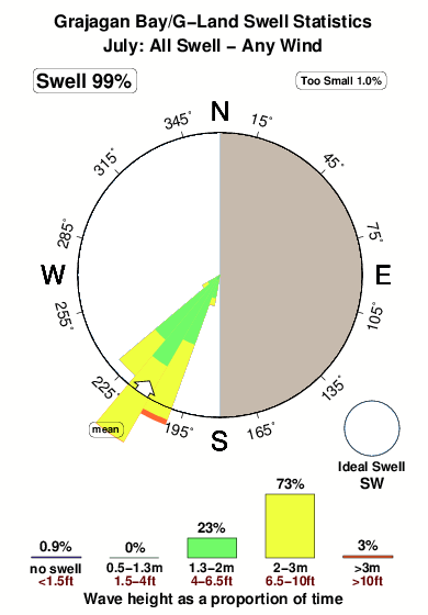
27°COverall Grajagan Bay/G-Land Surf Consistency and Wind Distribution in Luglio
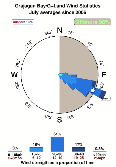


Wind stats for Grajagan Bay/G-Land: see the variation in direction and stength by month.
foto dall' album
Contorni: Strade e fiumi: seleziona un surf break dal menu 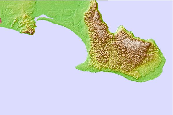
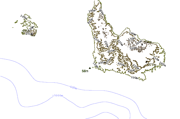
Utilizzare questa mappa sollievo per navigare Java - East surf breaks e stazioni di marea che si trovano nella zona diGrajagan Bay/G-Land
Altri surf breaks più vicini al Grajagan Bay/G-Land:
(clicca sul nome del luogo per maggiori informazioni)- Closest località surf10 mi
- Second closest località surf36 mi
- Third closest località surf43 mi
- Fourth closest località surf49 mi
- Fifth closest località surf49 mi
Onda boe più vicina a Grajagan Bay/G-Land:
- Closest Onda boa1874 mi
- Second closest Onda boa2182 mi
- Third closest Onda boa2304 mi
- Fourth closest Onda boa2354 mi
- Fifth closest Onda boa2379 mi
Stazioni di marea più vicina alla Grajagan Bay/G-Land:
- Closest marea stazioneWongsorejo50 mi
- Second closest marea stazioneBanjar54 mi
- Third closest marea stazioneDenpasar58 mi
- Fourth closest marea stazioneSingaraja66 mi
- Fifth closest marea stazionePanji71 mi
Airports
- The nearest passenger airport to Grajagan Bay/G-Land is Bali International (Denpasar) Airport (DPS) in Indonesia, which is 87 km (54 miles) away (directly).
- The second closest airport to Grajagan Bay/G-Land is Selaparang (Mataram) Airport (AMI), also in Indonesia, 190 km (118 miles) away.
- /breaks/Grajagan-Bay/forecasts/latest


 Nearest