
Hamamet ( Le Port) Surf Guide
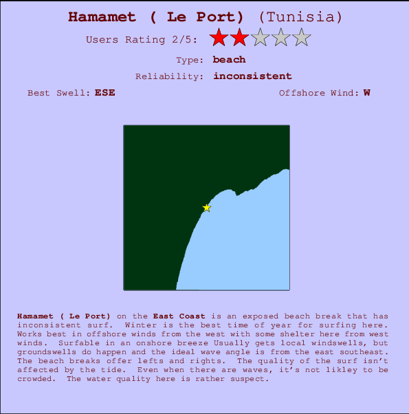
Hamamet ( Le Port) on the East Coast is an exposed beach break that only works once in a while. Winter is the optimum time of year for surfing here. Offshore winds are from the west with some shelter here from west winds. Still reasonable in light onshore winds Usually gets local windswells, but groundswells do happen and the optimum wave angle is from the east southeast. The beach break offers both left and right hand waves. Good surf at all stages of the tide. Unlikely to be too crowded, even when the surf is up. Pollution may be a hazard at this break.
Hamamet ( Le Port) Spot Info
| Type: | Rating: | Reliability: | Todays Sea Temp*: |
|---|---|---|---|
| inconsistent | 27.6°C*ocean temperature recorded from satellite |
Surfing Hamamet ( Le Port):
The best conditions reported for surf at Hamamet ( Le Port) occur when a East-southeast swell combines with an offshore wind direction from the West.
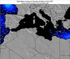
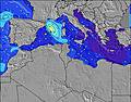
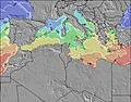
Previsioni Energia d'onda (Potenza): 12hrs

Hamamet ( Le Port) Surf:
Sunday, 19 July 2026, 00:56 Local time| Domenica 19 | ||||
| 10PM | 1AM | 4AM | 7AM | |
| Wave (m) | ||||
| Periodo (s) | - | - | - | - |
| Vento (km/h) | ||||
| Stato del vento | glass | cross- off |
cross- off |
cross- off |
- /breaks/Hamamet/forecasts/latest

Hamamet ( Le Port) Surf Guide
Hamamet ( Le Port) on the East Coast is an exposed beach break that only works once in a while. Winter is the optimum time of year for surfing here. Offshore winds are from the west with some shelter here from west winds. Still reasonable in light onshore winds Usually gets local windswells, but groundswells do happen and the optimum wave angle is from the east southeast. The beach break offers both left and right hand waves. Good surf at all stages of the tide. Unlikely to be too crowded, even when the surf is up. Pollution may be a hazard at this break.
Hamamet ( Le Port) Spot Info
Type: Rating: Reliability: Todays Sea Temp*:  Beach
Beach 2
2inconsistent 27.6°C*ocean temperature recorded from satelliteSurfing Hamamet ( Le Port):
The best conditions reported for surf at Hamamet ( Le Port) occur when a East-southeast swell combines with an offshore wind direction from the West.
Previsioni Energia d'onda (Potenza): 12hrs
Utilizzare la scheda di navigazione in alto per visualizzare Hamamet ( Le Port) temperatura del mare, Hamamet ( Le Port) fotografie, Hamamet ( Le Port) dettagliate previsioni onde, il vento e le previsioni meteo, Hamamet ( Le Port) webcam, vento corrente da East Coast stazioni meteo e Hamamet ( Le Port) previsioni marea. Il link Tunisia mappe maree apre l'immagine grande, che mostra Tunisia e dei mari circostanti. Queste mappe possono essere animate per mostrare le diverse componenti del moto ondoso, energia delle onde, periodo d'onda, altezza delle onde, insieme con le previsioni del vento e meteo, meteo corrente e osservazioni sullo stato del mare dal Tunisia onda-boe, le navi passanti e stazioni meteo costiere. Ciascuna delle pagine di previsioni per questo surf break rappresenta uno strumento di wavefinder globale e regionale per individuare le migliori condizioni di surf nella zona intorno Hamamet ( Le Port).
Hamamet ( Le Port) Surf:
Sunday, 19 July 2026, 00:56 Local timeDomenica 19 10PM 1AM 4AM 7AM Wave (m) Periodo (s) - - - - Vento (km/h) Stato del vento glass cross-
offcross-
offcross-
off- /breaks/Hamamet/forecasts/latest
- /breaks/Hamamet/forecasts/latest/six_day
Hamamet ( Le Port) Surf Guide
Hamamet ( Le Port) on the East Coast is an exposed beach break that only works once in a while. Winter is the optimum time of year for surfing here. Offshore winds are from the west with some shelter here from west winds. Still reasonable in light onshore winds Usually gets local windswells, but groundswells do happen and the optimum wave angle is from the east southeast. The beach break offers both left and right hand waves. Good surf at all stages of the tide. Unlikely to be too crowded, even when the surf is up. Pollution may be a hazard at this break.
Hamamet ( Le Port) Spot Info
Type: Rating: Reliability: Todays Sea Temp*: Beach2inconsistent 27.6°C*ocean temperature recorded from satelliteSurfing Hamamet ( Le Port):
The best conditions reported for surf at Hamamet ( Le Port) occur when a East-southeast swell combines with an offshore wind direction from the West.
Previsioni Energia d'onda (Potenza): 12hrs
Utilizzare la scheda di navigazione in alto per visualizzare Hamamet ( Le Port) temperatura del mare, Hamamet ( Le Port) fotografie, Hamamet ( Le Port) dettagliate previsioni onde, il vento e le previsioni meteo, Hamamet ( Le Port) webcam, vento corrente da East Coast stazioni meteo e Hamamet ( Le Port) previsioni marea. Il link Tunisia mappe maree apre l'immagine grande, che mostra Tunisia e dei mari circostanti. Queste mappe possono essere animate per mostrare le diverse componenti del moto ondoso, energia delle onde, periodo d'onda, altezza delle onde, insieme con le previsioni del vento e meteo, meteo corrente e osservazioni sullo stato del mare dal Tunisia onda-boe, le navi passanti e stazioni meteo costiere. Ciascuna delle pagine di previsioni per questo surf break rappresenta uno strumento di wavefinder globale e regionale per individuare le migliori condizioni di surf nella zona intorno Hamamet ( Le Port).
Hamamet ( Le Port) Surf:
Sunday, 19 July 2026, 00:56 Local timeDomenica 19 10PM 1AM 4AM 7AM Wave (m) Periodo (s) - - - - Vento (km/h) Stato del vento glass cross-
offcross-
offcross-
off- /breaks/Hamamet/forecasts/latest
Hamamet ( Le Port) Surf Guide
Hamamet ( Le Port) on the East Coast is an exposed beach break that only works once in a while. Winter is the optimum time of year for surfing here. Offshore winds are from the west with some shelter here from west winds. Still reasonable in light onshore winds Usually gets local windswells, but groundswells do happen and the optimum wave angle is from the east southeast. The beach break offers both left and right hand waves. Good surf at all stages of the tide. Unlikely to be too crowded, even when the surf is up. Pollution may be a hazard at this break.
Hamamet ( Le Port) Spot Info
Type: Rating: Reliability: Todays Sea Temp*: Beach2inconsistent 27.6°C*ocean temperature recorded from satelliteSurfing Hamamet ( Le Port):
The best conditions reported for surf at Hamamet ( Le Port) occur when a East-southeast swell combines with an offshore wind direction from the West.
Previsioni Energia d'onda (Potenza): 12hrs
Utilizzare la scheda di navigazione in alto per visualizzare Hamamet ( Le Port) temperatura del mare, Hamamet ( Le Port) fotografie, Hamamet ( Le Port) dettagliate previsioni onde, il vento e le previsioni meteo, Hamamet ( Le Port) webcam, vento corrente da East Coast stazioni meteo e Hamamet ( Le Port) previsioni marea. Il link Tunisia mappe maree apre l'immagine grande, che mostra Tunisia e dei mari circostanti. Queste mappe possono essere animate per mostrare le diverse componenti del moto ondoso, energia delle onde, periodo d'onda, altezza delle onde, insieme con le previsioni del vento e meteo, meteo corrente e osservazioni sullo stato del mare dal Tunisia onda-boe, le navi passanti e stazioni meteo costiere. Ciascuna delle pagine di previsioni per questo surf break rappresenta uno strumento di wavefinder globale e regionale per individuare le migliori condizioni di surf nella zona intorno Hamamet ( Le Port).
Hamamet ( Le Port) Surf:
Sunday, 19 July 2026, 00:56 Local timeDomenica 19 10PM 1AM 4AM 7AM Wave (m) Periodo (s) - - - - Vento (km/h) Stato del vento glass cross-
offcross-
offcross-
offTide Times:
Per Al Hammamat, %{dist} %{km} da %{location}.
PROSSIMA È ALLE (ora locale) rimanente alta marea bassa marea Hamamet ( Le Port) Tide Times and Tide Chart
Live Weather:
At Enfidha–Hammamet International Airport, 35 km from Hamamet ( Le Port).
light winds from the N
(km/h)Air temperature
Q1013°Cfoto dall' album
Contorni: Strade e fiumi: seleziona un surf break dal menu 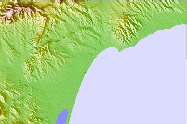
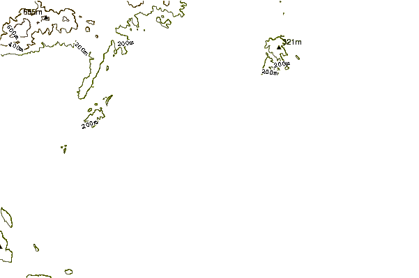
Utilizzare questa mappa sollievo per navigare East Coast surf breaks e stazioni di marea che si trovano nella zona diHamamet ( Le Port)
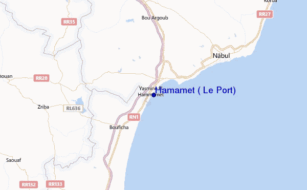
Altri surf breaks più vicini al Hamamet ( Le Port):
(clicca sul nome del luogo per maggiori informazioni)- Closest località surf35 mi
- Second closest località surf37 mi
- Third closest località surf38 mi
- Fourth closest località surf45 mi
- Fifth closest località surf75 mi
Onda boe più vicina a Hamamet ( Le Port):
- Closest Onda boa505 mi
- Second closest Onda boa507 mi
- Third closest Onda boa1014 mi
- Fourth closest Onda boa1022 mi
- Fifth closest Onda boa1076 mi
Stazioni di marea più vicina alla Hamamet ( Le Port):
- Closest marea stazioneAl Hammamat4 mi
- Second closest marea stazioneDouane12 mi
- Third closest marea stazioneDar Chabanne13 mi
- Fourth closest marea stazioneEl Maamoura16 mi
- Fifth closest marea stazioneKorba22 mi
Airports
- The closest passenger airport to Hamamet ( Le Port) is Carthage (Tunis) Airport (TUN) in Tunisia, 61 km (38 miles) away (directly).
- The second nearest airport to Hamamet ( Le Port) is Habib Bourguiba International (Monastir) Airport (MIR), also in Tunisia, 71 km (44 miles) away.
- Third is Pantelleria Airport (PNL) in Italy, 136 km (84 miles) away.
- Thyna (Sfax) Airport (SFA) in Tunisia is 184 km (114 miles) away.
- Lampedusa Airport (LMP) in Italy is the fifth nearest airport to Hamamet ( Le Port) and is 210 km (130 miles) away.
- /breaks/Hamamet/forecasts/latest


 Nearest