
Previsioni:

Previsione a breve termineper lo più asciutto. Warm (Max 25°C martedì mattina, Min 20°C Domenica mattina). Vento sarà generalmente leggero. | ||||||||||||||||||||||||
Domenica 19 | Lunedì 20 | Martedì 21 | ||||||||||||||||||||||
2 AM | 5 AM | 8 AM | 11 AM | 2 PM | 5 PM | 8 PM | 11 PM | 2 AM | 5 AM | 8 AM | 11 AM | 2 PM | 5 PM | 8 PM | 11 PM | 2 AM | 5 AM | 8 AM | 11 AM | 2 PM | 5 PM | 8 PM | 11 PM | |
Mappa dell'altezza del moto ondoso |  |  |  |  |  |  |  | 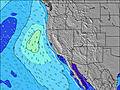 |  | |||||||||||||||
Onda Altezza (m) Direzione Periodo (s) | SW 16 | SW 16 | SW 16 | SW 17 | SW 17 | SW 17 | SW 17 | SW 17 | SW 16 | SSW 15 | SSW 15 | SSW 15 | SSW 16 | SW 16 | SW 16 | SW 16 | SSW 16 | SSW 16 | SSW 16 | SSW 16 | SSW 15 | SSW 15 | SSW 15 | SSW 15 |
Grafico delle onde | ||||||||||||||||||||||||
66 | 64 | 163 | 235 | 238 | 235 | 230 | 232 | 211 | 199 | 246 | 193 | 162 | 201 | 203 | 261 | 177 | 179 | 339 | 362 | 298 | 291 | 291 | 291 | |
Vento (km/h) | ||||||||||||||||||||||||
Stato del vento onshore cross-onshore cross-shore cross-offshore offshore piatto | cross | cross | cross-off | cross-on | cross-on | on | on | cross-on | cross-on | glassy | cross | cross-on | cross-on | on | on | cross-on | cross-on | cross-off | cross-off | cross | cross-on | on | on | cross-on |
Alta Marea | 1:16AM1.36m | 2:35PM1.43m | 2:20AM1.10m | 3:22PM1.44m | 3:53AM0.90m | 4:14PM1.46m | ||||||||||||||||||
Basso Marea | 7:48AM0.16m | 8:50PM0.53m | 8:24AM0.38m | 10:21PM0.48m | 9:02AM0.57m | |||||||||||||||||||
— | 5:56 | — | — | — | — | — | — | — | 5:56 | — | — | — | — | — | — | — | 5:56 | — | — | — | — | — | — | |
— | — | — | — | — | — | 8:02 | — | — | — | — | — | — | — | 8:01 | — | — | — | — | — | — | — | 8:01 | — | |
mm | — | — | — | — | — | — | — | — | — | — | — | — | — | — | — | — | — | — | — | — | — | — | — | — |
Temp. °C | 19 | 19 | 20 | 22 | 22 | 22 | 22 | 21 | 20 | 20 | 21 | 23 | 24 | 24 | 24 | 22 | 21 | 21 | 22 | 25 | 25 | 25 | 23 | 21 |
Gelo °C | 20 | 21 | 21 | 22 | 21 | 21 | 23 | 22 | 21 | 22 | 22 | 24 | 23 | 22 | 22 | 22 | 21 | 21 | 22 | 25 | 24 | 24 | 22 | 21 |
Onda 1 Altezza (m) Direzione Periodo (s) | W 5 | W 6 | SW 16 | SW 17 | SW 17 | SW 17 | SW 17 | S 12 | S 12 | SSW 15 | SSW 15 | SSW 15 | SSW 16 | SW 16 | SW 16 | SW 16 | W 6 | W 6 | SSW 16 | SSW 16 | SSW 15 | SSW 15 | SSW 15 | SSW 15 |
7 | 15 | 163 | 235 | 238 | 235 | 230 | 138 | 98 | 199 | 246 | 193 | 162 | 201 | 203 | 261 | 30 | 22 | 339 | 362 | 298 | 291 | 291 | 291 | |
Onda 2 Altezza (m) Direzione Periodo (s) | SSE 11 | SSE 11 | W 6 | SSE 11 | S 13 | S 13 | S 12 | SW 17 | SW 16 | S 12 | S 11 | S 11 | S 11 | S 11 | S 11 | S 11 | SSW 16 | SSW 16 | W 5 | W 5 | W 5 | SSW 9 | SSW 9 | W 5 |
39 | 38 | 15 | 38 | 123 | 112 | 103 | 232 | 211 | 95 | 57 | 82 | 89 | 88 | 86 | 82 | 177 | 179 | 13 | 13 | 13 | 27 | 27 | 20 | |
Onda 3 Altezza (m) Direzione Periodo (s) | SW 16 | SW 16 | SSE 11 | W 5 | WSW 5 | W 15 | W 15 | W 15 | WSW 5 | W 5 | W 5 | W 5 | W 5 | SSW 20 | SSW 13 | W 5 | SW 13 | SW 13 | S 10 | SSE 14 | SSW 9 | SSE 13 | SW 21 | SSW 9 |
66 | 64 | 38 | 9 | 10 | 17 | 17 | 17 | 8 | 12 | 8 | 8 | 8 | 37 | 17 | 11 | 85 | 84 | 49 | 20 | 29 | 16 | 18 | 26 | |
onde vento Altezza (m) Direzione Periodo (s) | — | — | — | — | — | W 5 | W 5 | WSW 4 | — | — | — | — | — | W 5 | W 3 | — | — | — | — | — | — | W 5 | W 5 | — |
— | — | — | — | — | 5 | 4 | 6 | — | — | — | — | — | 7 | 3 | — | — | — | — | — | — | 8 | 10 | — | |
Il più vicino Offshore or Glassy | ||||||||||||||||||||||||
Distanza (km) | 12 | 1 | 0 | 11 | 142 | 110 | 33 | 28 | 11 | 0 | 0 | 12 | 142 | 110 | 33 | 12 | 11 | 0 | 0 | 0 | 142 | 48 | 33 | 12 |
Migliori previsioni per le condizioni d'onda in Los Angeles County | ||||||||||||||||||||||||
Migliori previsioni per le condizioni d'onda in United States | ||||||||||||||||||||||||
Trova Onde Globale | ||||||||||||||||||||||||
- Map Icons:
 Break
Break Live Wave Height (m)
 Live Wind Speed (km/h)
 Surf Rating (10 Max)
 Ocean Swells (m)
- Wind Speed (km/h)
Widget Free Surf-Forecast.com per il tuo sito
La relazione di surf / widget meteo è disponibile qui sotto per incorporare su siti esterni a titolo gratuito e fornisce una sintesi delle nostre Hammerland previsione surf. Basta prendere il frammento di codice html da noi fornito e copiarlo nel proprio sito. È possibile scegliere la lingua preferita e unità metriche / imperiali per il feed delle previsioni surf per soddisfare le esigenze degli utenti del vostro sito .... Clicca qui per ottenere il codice.
 Nearest