
Previsioni:

Previsione a breve termineper lo più asciutto. Warm (Max 23°C Venerdì pomeriggio, Min 20°C giovedì notte). Vento sarà generalmente leggero. | ||||||||||||||||||||
Gio 30 | Venerdì 31 | Sabato 1 | ||||||||||||||||||
2 PM | 5 PM | 8 PM | 11 PM | 2 AM | 5 AM | 8 AM | 11 AM | 2 PM | 5 PM | 8 PM | 11 PM | 2 AM | 5 AM | 8 AM | 11 AM | 2 PM | 5 PM | 8 PM | 11 PM | |
Mappa dell'altezza del moto ondoso |  | 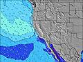 |  |  |  |  |  |  | ||||||||||||
Onda Altezza (m) Direzione Periodo (s) | SSW 14 | SSW 14 | SSW 14 | SSW 14 | SSW 14 | SSW 14 | SW 14 | SSW 14 | SW 14 | SSW 14 | SW 14 | SW 14 | SW 14 | SW 14 | SW 14 | SW 13 | SSW 13 | SW 13 | SW 14 | SW 13 |
Grafico delle onde | ||||||||||||||||||||
697 | 697 | 687 | 668 | 631 | 561 | 293 | 561 | 268 | 232 | 264 | 191 | 189 | 189 | 264 | 215 | 304 | 183 | 114 | 113 | |
Vento (km/h) | ||||||||||||||||||||
Stato del vento onshore cross-onshore cross-shore cross-offshore offshore piatto | cross-on | cross-on | cross-on | glassy | glassy | cross | cross | cross-on | cross-on | cross-on | cross | glassy | cross-on | cross-on | cross-on | cross-on | on | on | cross-on | on |
Alta Marea | 11:02AM1.30m | 10:11PM1.87m | 11:29AM1.35m | 10:44PM1.77m | 11:57AM1.41m | |||||||||||||||
Basso Marea | 4:22PM0.59m | 5:27AM-0.13m | 5:00PM0.57m | 5:53AM-0.05m | 5:41PM0.55m | |||||||||||||||
— | — | — | — | — | 6:01 | — | — | — | — | — | — | — | 6:01 | — | — | — | — | — | — | |
— | 7:49 | — | — | — | — | — | — | — | 7:47 | — | — | — | — | — | — | — | 7:46 | — | — | |
mm | — | — | — | — | — | — | — | — | — | — | — | — | — | — | — | — | — | — | — | — |
Temp. °C | 21 | 21 | 20 | 20 | 20 | 20 | 21 | 22 | 22 | 23 | 22 | 23 | 22 | 21 | 22 | 23 | 23 | 23 | 22 | 22 |
Gelo °C | 21 | 21 | 21 | 22 | 22 | 21 | 23 | 22 | 22 | 24 | 23 | 25 | 24 | 23 | 24 | 24 | 23 | 23 | 23 | 24 |
Onda 1 Altezza (m) Direzione Periodo (s) | SSW 14 | SSW 14 | SSW 14 | SSW 14 | SSW 14 | SSW 14 | SW 14 | SSW 14 | SW 14 | SSW 14 | SW 14 | SSW 10 | SW 14 | SW 14 | SW 14 | SW 13 | SSW 13 | W 8 | SSW 10 | SSW 10 |
697 | 697 | 687 | 668 | 631 | 561 | 293 | 561 | 268 | 232 | 264 | 108 | 189 | 189 | 264 | 215 | 304 | 58 | 88 | 85 | |
Onda 2 Altezza (m) Direzione Periodo (s) | W 7 | W 6 | W 6 | W 9 | W 9 | WNW 9 | SSW 12 | WNW 7 | SSW 11 | SSW 11 | S 10 | SW 14 | S 10 | S 9 | W 7 | W 7 | WNW 7 | SW 13 | W 8 | W 8 |
32 | 21 | 20 | 42 | 41 | 26 | 186 | 17 | 156 | 119 | 70 | 191 | 94 | 63 | 36 | 54 | 57 | 183 | 61 | 44 | |
Onda 3 Altezza (m) Direzione Periodo (s) | W 8 | WNW 7 | — | — | — | S 9 | WNW 9 | W 8 | W 7 | W 7 | W 8 | W 8 | W 8 | W 7 | S 9 | S 9 | SW 20 | SW 10 | SW 14 | SW 13 |
1 | 35 | — | — | — | 27 | 26 | 31 | 25 | 38 | 31 | 30 | 29 | 26 | 41 | 40 | 15 | 51 | 114 | 113 | |
onde vento Altezza (m) Direzione Periodo (s) | — | — | — | — | — | — | — | — | — | — | — | — | — | — | — | — | — | — | — | — |
— | — | — | — | — | — | — | — | — | — | — | — | — | — | — | — | — | — | — | — | |
Il più vicino Offshore or Glassy | ||||||||||||||||||||
Distanza (km) | 630 | 16 | 16 | 0 | 0 | 14 | 7 | 16 | 16 | 16 | 16 | 0 | 7 | 6 | 6 | 16 | 16 | 16 | 16 | 2 |
Migliori previsioni per le condizioni d'onda in San Diego County | ||||||||||||||||||||
Migliori previsioni per le condizioni d'onda in United States | ||||||||||||||||||||
Trova Onde Globale | ||||||||||||||||||||
- Map Icons:
 Break
Break Live Wave Height (m)
 Live Wind Speed (km/h)
 Surf Rating (10 Max)
 Ocean Swells (m)
- Wind Speed (km/h)
Widget Free Surf-Forecast.com per il tuo sito
La relazione di surf / widget meteo è disponibile qui sotto per incorporare su siti esterni a titolo gratuito e fornisce una sintesi delle nostre Hennemans previsione surf. Basta prendere il frammento di codice html da noi fornito e copiarlo nel proprio sito. È possibile scegliere la lingua preferita e unità metriche / imperiali per il feed delle previsioni surf per soddisfare le esigenze degli utenti del vostro sito .... Clicca qui per ottenere il codice.
 Nearest