
Previsioni:

Previsione a breve termineper lo più asciutto. Warm (Max 22°C Sabato mattina, Min 19°C Venerdì notte). Vento sarà generalmente leggero. | |||||||||||||||||||||
Ven 17 | Sabato 18 | Domenica 19 | |||||||||||||||||||
11 AM | 2 PM | 5 PM | 8 PM | 11 PM | 2 AM | 5 AM | 8 AM | 11 AM | 2 PM | 5 PM | 8 PM | 11 PM | 2 AM | 5 AM | 8 AM | 11 AM | 2 PM | 5 PM | 8 PM | 11 PM | |
Mappa dell'altezza del moto ondoso |  |  | 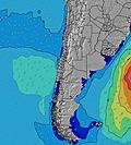 | 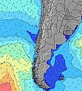 |  |  | 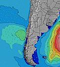 | 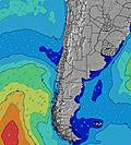 | |||||||||||||
Onda Altezza (m) Direzione Periodo (s) | WSW 9 | WSW 12 | WSW 11 | WSW 11 | WSW 11 | WSW 10 | WSW 10 | WSW 10 | WSW 10 | WSW 10 | WSW 10 | WSW 10 | WSW 10 | WSW 13 | WSW 12 | WSW 12 | WSW 12 | WSW 12 | WSW 12 | WSW 12 | WSW 11 |
Grafico delle onde | |||||||||||||||||||||
52 | 235 | 329 | 334 | 379 | 310 | 274 | 255 | 250 | 250 | 250 | 250 | 250 | 522 | 531 | 514 | 505 | 437 | 429 | 361 | 337 | |
Vento (km/h) | |||||||||||||||||||||
Stato del vento onshore cross-onshore cross-shore cross-offshore offshore piatto | on | on | glassy | cross-on | cross | glassy | glassy | glassy | on | on | glassy | glassy | glassy | glassy | glassy | glassy | cross-on | cross-on | cross | cross | cross-off |
Alta Marea | 11:30AM1.31m | 00:10AM0.84m | 12:15PM1.21m | 1:02AM0.87m | 1:01PM1.08m | ||||||||||||||||
Basso Marea | 6:15PM-0.03m | 5:48AM0.12m | 6:57PM0.01m | 6:45AM0.20m | 7:39PM0.07m | ||||||||||||||||
— | — | — | — | — | — | 7:20 | — | — | — | — | — | — | — | 7:20 | — | — | — | — | — | — | |
— | — | 6:13 | — | — | — | — | — | — | — | 6:14 | — | — | — | — | — | — | — | 6:14 | — | — | |
mm | — | — | — | — | — | — | — | — | — | — | — | — | — | — | — | — | — | — | — | — | — |
Temp. °C | 22 | 21 | 21 | 19 | 19 | 20 | 19 | 20 | 22 | 22 | 21 | 19 | 20 | 20 | 20 | 20 | 22 | 21 | 19 | 19 | 19 |
Gelo °C | 21 | 20 | 21 | 18 | 18 | 20 | 18 | 19 | 20 | 21 | 21 | 19 | 20 | 19 | 19 | 19 | 20 | 19 | 18 | 18 | 18 |
Onda 1 Altezza (m) Direzione Periodo (s) | WSW 9 | WSW 12 | WSW 11 | WSW 11 | WSW 11 | WSW 10 | WSW 10 | WSW 10 | WSW 10 | WSW 10 | WSW 10 | WSW 10 | WSW 10 | WSW 13 | WSW 12 | WSW 12 | WSW 12 | WSW 12 | WSW 12 | WSW 12 | WSW 11 |
52 | 235 | 329 | 334 | 379 | 310 | 274 | 255 | 250 | 250 | 250 | 250 | 250 | 522 | 531 | 514 | 505 | 437 | 429 | 361 | 337 | |
Onda 2 Altezza (m) Direzione Periodo (s) | SW 12 | SW 17 | SW 16 | SW 16 | SW 16 | SW 15 | SSW 15 | SW 14 | SW 14 | SSW 14 | SW 13 | SW 13 | WSW 13 | SW 12 | SSW 12 | SSW 13 | SSW 13 | SSW 13 | SSW 13 | SSW 12 | SSW 12 |
51 | 44 | 66 | 64 | 62 | 56 | 84 | 102 | 97 | 71 | 87 | 140 | 101 | 71 | 56 | 111 | 67 | 66 | 65 | 58 | 56 | |
Onda 3 Altezza (m) Direzione Periodo (s) | WNW 12 | WNW 12 | WNW 12 | WNW 12 | WNW 12 | NW 12 | SW 11 | SSW 10 | SW 11 | SW 10 | WSW 14 | WSW 13 | SSW 13 | SSW 14 | SSW 15 | NW 11 | NW 11 | NW 11 | NW 11 | NW 11 | NW 11 |
14 | 14 | 14 | 14 | 14 | 6 | 20 | 11 | 18 | 28 | 37 | 60 | 114 | 41 | 21 | 5 | 5 | 5 | 5 | 5 | 5 | |
onde vento Altezza (m) Direzione Periodo (s) | — | — | — | — | — | — | — | — | — | — | — | — | — | — | — | — | — | — | — | — | — |
— | — | — | — | — | — | — | — | — | — | — | — | — | — | — | — | — | — | — | — | — | |
Il più vicino Offshore or Glassy | |||||||||||||||||||||
Distanza (km) | 127 | 87 | 0 | 61 | 61 | 0 | 0 | 0 | 71 | 61 | 0 | 0 | 0 | 0 | 0 | 0 | 127 | 90 | 103 | 51 | 0 |
Migliori previsioni per le condizioni d'onda in Antofagasta | |||||||||||||||||||||
Migliori previsioni per le condizioni d'onda in Chile | |||||||||||||||||||||
Trova Onde Globale | |||||||||||||||||||||
- Map Icons:
 Break
Break Live Wave Height (m)
 Live Wind Speed (km/h)
 Surf Rating (10 Max)
 Ocean Swells (m)
- Wind Speed (km/h)
Widget Free Surf-Forecast.com per il tuo sito
La relazione di surf / widget meteo è disponibile qui sotto per incorporare su siti esterni a titolo gratuito e fornisce una sintesi delle nostre Hornitos previsione surf. Basta prendere il frammento di codice html da noi fornito e copiarlo nel proprio sito. È possibile scegliere la lingua preferita e unità metriche / imperiali per il feed delle previsioni surf per soddisfare le esigenze degli utenti del vostro sito .... Clicca qui per ottenere il codice.
 Nearest