
Previsioni:

Previsione a breve termineper lo più asciutto. Very mild (Max 19°C Domenica mattina, Min 17°C Sabato mattina). Vento sarà generalmente leggero. | ||||||||||||||||||||||||
Sabato 18 | Domenica 19 | Lunedì 20 | ||||||||||||||||||||||
2 AM | 5 AM | 8 AM | 11 AM | 2 PM | 5 PM | 8 PM | 11 PM | 2 AM | 5 AM | 8 AM | 11 AM | 2 PM | 5 PM | 8 PM | 11 PM | 2 AM | 5 AM | 8 AM | 11 AM | 2 PM | 5 PM | 8 PM | 11 PM | |
Mappa dell'altezza del moto ondoso |  | 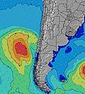 |  |  | 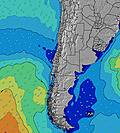 |  |  | 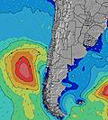 |  | |||||||||||||||
Onda Altezza (m) Direzione Periodo (s) | WSW 10 | WSW 10 | WSW 10 | WSW 10 | WSW 10 | WSW 10 | WSW 10 | WSW 10 | WSW 13 | WSW 12 | WSW 12 | WSW 12 | WSW 12 | WSW 12 | WSW 12 | WSW 11 | WSW 11 | WSW 11 | WSW 11 | WSW 11 | WSW 11 | WSW 11 | WSW 12 | WSW 12 |
Grafico delle onde | ||||||||||||||||||||||||
320 | 294 | 250 | 250 | 250 | 250 | 250 | 294 | 594 | 522 | 514 | 505 | 505 | 437 | 422 | 320 | 363 | 363 | 356 | 356 | 370 | 325 | 343 | 283 | |
Vento (km/h) | ||||||||||||||||||||||||
Stato del vento onshore cross-onshore cross-shore cross-offshore offshore piatto | cross | cross | cross | glassy | glassy | glassy | glassy | glassy | cross-off | cross-on | cross | cross-on | cross-on | glassy | cross-off | cross-on | glassy | glassy | cross | on | glassy | glassy | glassy | cross |
Alta Marea | 00:15AM0.86m | 12:20PM1.23m | 1:07AM0.89m | 1:06PM1.09m | 2:00AM0.91m | 1:53PM0.95m | ||||||||||||||||||
Basso Marea | 5:54AM0.12m | 7:02PM0.01m | 6:51AM0.20m | 7:43PM0.07m | 7:52AM0.28m | 8:25PM0.13m | ||||||||||||||||||
— | 7:22 | — | — | — | — | — | — | — | 7:22 | — | — | — | — | — | — | — | 7:22 | — | — | — | — | — | — | |
— | — | — | — | — | 6:13 | — | — | — | — | — | — | — | 6:13 | — | — | — | — | — | — | — | 6:14 | — | — | |
mm | — | — | — | — | — | — | — | — | — | — | — | — | — | — | — | — | — | — | — | — | — | — | — | — |
Temp. °C | 17 | 17 | 17 | 18 | 17 | 17 | 18 | 18 | 18 | 18 | 18 | 19 | 18 | 17 | 18 | 18 | 18 | 17 | 18 | 18 | 17 | 18 | 17 | 19 |
Gelo °C | 16 | 15 | 16 | 18 | 17 | 17 | 18 | 18 | 18 | 17 | 16 | 17 | 17 | 17 | 17 | 17 | 18 | 17 | 17 | 17 | 17 | 18 | 17 | 18 |
Onda 1 Altezza (m) Direzione Periodo (s) | WSW 10 | WSW 10 | WSW 10 | WSW 10 | WSW 10 | WSW 10 | WSW 10 | WSW 10 | WSW 13 | WSW 12 | WSW 12 | WSW 12 | WSW 12 | WSW 12 | WSW 12 | WSW 11 | WSW 11 | WSW 11 | WSW 11 | WSW 11 | WSW 11 | WSW 11 | WSW 12 | WSW 12 |
320 | 294 | 250 | 250 | 250 | 250 | 250 | 294 | 594 | 522 | 514 | 505 | 505 | 437 | 422 | 320 | 363 | 363 | 356 | 356 | 370 | 325 | 343 | 283 | |
Onda 2 Altezza (m) Direzione Periodo (s) | SSW 15 | SSW 14 | SW 14 | SW 14 | SW 13 | SSW 13 | SW 13 | SSW 12 | SSW 12 | SSW 12 | SSW 13 | SSW 13 | SSW 13 | SSW 13 | SSW 12 | SSW 12 | SSW 12 | SSW 12 | SSW 12 | SSW 11 | SSW 11 | SSW 11 | SSW 11 | SSW 12 |
85 | 140 | 100 | 92 | 88 | 116 | 175 | 104 | 56 | 101 | 113 | 114 | 113 | 109 | 57 | 56 | 56 | 56 | 55 | 51 | 47 | 49 | 70 | 53 | |
Onda 3 Altezza (m) Direzione Periodo (s) | SW 12 | SSW 11 | SW 11 | SW 11 | SW 11 | WSW 13 | WSW 13 | WSW 13 | SSW 14 | SW 15 | NW 11 | NW 11 | NW 11 | NW 11 | NW 11 | NW 11 | NW 11 | — | W 23 | W 23 | NW 10 | NW 10 | W 22 | W 22 |
34 | 12 | 19 | 30 | 29 | 58 | 59 | 101 | 41 | 8 | 5 | 5 | 5 | 5 | 5 | 5 | 5 | — | 11 | 10 | 4 | 4 | 10 | 10 | |
onde vento Altezza (m) Direzione Periodo (s) | — | — | — | — | — | — | — | — | — | — | — | — | — | — | — | — | — | — | — | — | — | — | — | — |
— | — | — | — | — | — | — | — | — | — | — | — | — | — | — | — | — | — | — | — | — | — | — | — | |
Il più vicino Offshore or Glassy | ||||||||||||||||||||||||
Distanza (km) | 22 | 43 | 43 | 0 | 0 | 0 | 0 | 0 | 0 | 22 | 6 | 223 | 174 | 0 | 0 | 14 | 0 | 0 | 6 | 223 | 0 | 0 | 0 | 6 |
Migliori previsioni per le condizioni d'onda in Antofagasta | ||||||||||||||||||||||||
Migliori previsioni per le condizioni d'onda in Chile | ||||||||||||||||||||||||
Trova Onde Globale | ||||||||||||||||||||||||
- Map Icons:
 Break
Break Live Wave Height (m)
 Live Wind Speed (km/h)
 Surf Rating (10 Max)
 Ocean Swells (m)
- Wind Speed (km/h)
Widget Free Surf-Forecast.com per il tuo sito
La relazione di surf / widget meteo è disponibile qui sotto per incorporare su siti esterni a titolo gratuito e fornisce una sintesi delle nostre Huascar previsione surf. Basta prendere il frammento di codice html da noi fornito e copiarlo nel proprio sito. È possibile scegliere la lingua preferita e unità metriche / imperiali per il feed delle previsioni surf per soddisfare le esigenze degli utenti del vostro sito .... Clicca qui per ottenere il codice.
 Nearest