
Previsioni:

Previsione a breve termineper lo più asciutto. Warm (Max 20°C giovedì mattina, Min 17°C Venerdì notte). Vento sarà generalmente leggero. | ||||||||||||||||||||||||
Mer 15 | Giovedì 16 | Venerdì 17 | 18 | |||||||||||||||||||||
11 AM | 2 PM | 5 PM | 8 PM | 11 PM | 2 AM | 5 AM | 8 AM | 11 AM | 2 PM | 5 PM | 8 PM | 11 PM | 2 AM | 5 AM | 8 AM | 11 AM | 2 PM | 5 PM | 8 PM | 11 PM | 2 AM | 5 AM | 8 AM | |
Mappa dell'altezza del moto ondoso |  |  | 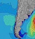 | 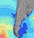 |  |  | 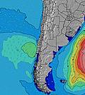 | 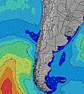 |  | |||||||||||||||
Onda Altezza (m) Direzione Periodo (s) | SW 14 | SW 12 | SW 12 | SW 13 | SW 13 | SW 13 | SW 13 | SW 13 | SW 13 | SW 12 | SW 12 | SW 12 | SW 12 | SW 12 | SW 12 | SW 12 | SW 12 | SW 11 | SW 13 | SW 12 | SW 11 | SW 11 | SW 11 | WSW 11 |
Grafico delle onde | ||||||||||||||||||||||||
459 | 712 | 736 | 721 | 755 | 814 | 732 | 732 | 581 | 546 | 486 | 423 | 367 | 314 | 232 | 232 | 158 | 145 | 80 | 236 | 331 | 389 | 431 | 389 | |
Vento (km/h) | ||||||||||||||||||||||||
Stato del vento onshore cross-onshore cross-shore cross-offshore offshore piatto | on | cross-on | cross-on | glassy | glassy | glassy | glassy | cross-on | glassy | glassy | cross-on | glassy | glassy | cross-on | glassy | cross-on | on | on | glassy | glassy | glassy | cross-on | cross-on | cross-on |
Alta Marea | 9:45AM1.58m | 10:13PM0.94m | 10:32AM1.56m | 11:05PM0.97m | 11:19AM1.49m | 11:57PM1.00m | ||||||||||||||||||
Basso Marea | 4:39PM0.24m | 3:46AM0.27m | 5:24PM0.23m | 4:39AM0.31m | 6:08PM0.25m | 5:33AM0.37m | ||||||||||||||||||
— | — | — | — | — | — | 7:15 | — | — | — | — | — | — | — | 7:15 | — | — | — | — | — | — | — | 7:15 | — | |
— | — | 6:16 | — | — | — | — | — | — | — | 6:16 | — | — | — | — | — | — | — | 6:16 | — | — | — | — | 6:17 | |
mm | — | — | — | — | — | — | — | — | — | — | — | — | — | — | — | — | — | — | — | — | — | — | — | — |
Temp. °C | 19 | 19 | 19 | 18 | 18 | 18 | 18 | 18 | 20 | 20 | 20 | 18 | 18 | 18 | 18 | 18 | 20 | 20 | 18 | 17 | 18 | 18 | 18 | 18 |
Gelo °C | 18 | 19 | 18 | 18 | 18 | 19 | 18 | 18 | 20 | 20 | 20 | 18 | 18 | 18 | 18 | 17 | 20 | 20 | 18 | 18 | 18 | 17 | 17 | 17 |
Onda 1 Altezza (m) Direzione Periodo (s) | WSW 12 | SW 12 | SW 12 | SW 13 | SW 13 | SW 13 | SW 13 | SW 13 | SW 13 | SW 12 | SW 12 | SW 12 | SW 12 | SW 12 | SW 12 | SW 12 | SW 12 | SW 11 | SW 9 | SW 12 | SW 11 | SW 11 | SW 11 | WSW 11 |
384 | 712 | 736 | 721 | 755 | 814 | 732 | 732 | 581 | 546 | 486 | 423 | 367 | 314 | 232 | 232 | 158 | 145 | 52 | 236 | 331 | 389 | 431 | 389 | |
Onda 2 Altezza (m) Direzione Periodo (s) | SW 14 | WNW 13 | WNW 13 | SSW 6 | SSW 6 | NW 13 | WNW 13 | NW 13 | NW 12 | W 10 | W 10 | W 10 | W 10 | W 10 | W 9 | SW 18 | WSW 9 | SW 18 | SW 13 | SW 16 | SW 16 | SW 16 | SW 16 | SW 15 |
459 | 17 | 17 | 3 | 3 | 7 | 17 | 7 | 6 | 8 | 8 | 8 | 8 | 7 | 7 | 13 | 8 | 49 | 80 | 69 | 91 | 90 | 119 | 107 | |
Onda 3 Altezza (m) Direzione Periodo (s) | WNW 13 | — | WNW 13 | WNW 13 | WNW 13 | SW 6 | — | — | — | NW 12 | NW 12 | NW 12 | NW 12 | NW 12 | WNW 12 | WNW 12 | SW 18 | WSW 9 | SW 18 | W 9 | NW 12 | NW 12 | NW 12 | NW 11 |
17 | — | 17 | 17 | 17 | 1 | — | — | — | 6 | 6 | 6 | 6 | 6 | 14 | 14 | 50 | 8 | 49 | 6 | 6 | 5 | 5 | 5 | |
onde vento Altezza (m) Direzione Periodo (s) | — | — | SSW 6 | — | — | — | — | — | — | — | — | — | — | — | — | — | — | — | — | — | — | — | — | — |
— | — | 3 | — | — | — | — | — | — | — | — | — | — | — | — | — | — | — | — | — | — | — | — | — | |
Il più vicino Offshore or Glassy | ||||||||||||||||||||||||
Distanza (km) | 3 | 3 | 3 | 0 | 0 | 0 | 0 | 2 | 0 | 0 | 3 | 0 | 0 | 3 | 0 | 3 | 3 | 3 | 0 | 0 | 0 | 3 | 3 | 3 |
Migliori previsioni per le condizioni d'onda in Tarapaca | ||||||||||||||||||||||||
Migliori previsioni per le condizioni d'onda in Chile | ||||||||||||||||||||||||
Trova Onde Globale | ||||||||||||||||||||||||
- Map Icons:
 Break
Break Live Wave Height (m)
 Live Wind Speed (km/h)
 Surf Rating (10 Max)
 Ocean Swells (m)
- Wind Speed (km/h)
Widget Free Surf-Forecast.com per il tuo sito
La relazione di surf / widget meteo è disponibile qui sotto per incorporare su siti esterni a titolo gratuito e fornisce una sintesi delle nostre Huayquique previsione surf. Basta prendere il frammento di codice html da noi fornito e copiarlo nel proprio sito. È possibile scegliere la lingua preferita e unità metriche / imperiali per il feed delle previsioni surf per soddisfare le esigenze degli utenti del vostro sito .... Clicca qui per ottenere il codice.
 Nearest