
Previsioni:

Previsione a breve termineper lo più asciutto. Very mild (Max 19°C Domenica mattina, Min 16°C Lunedì notte). Vento sarà generalmente leggero. | |||||||||||||||||||||||
Domenica 19 | Lunedì 20 | Martedì 21 | |||||||||||||||||||||
5 AM | 8 AM | 11 AM | 2 PM | 5 PM | 8 PM | 11 PM | 2 AM | 5 AM | 8 AM | 11 AM | 2 PM | 5 PM | 8 PM | 11 PM | 2 AM | 5 AM | 8 AM | 11 AM | 2 PM | 5 PM | 8 PM | 11 PM | |
Mappa dell'altezza del moto ondoso | 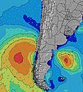 | 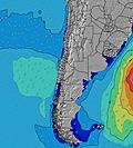 | 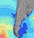 |  | 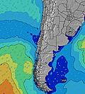 |  |  | 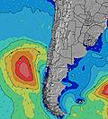 |  | ||||||||||||||
Onda Altezza (m) Direzione Periodo (s) | WSW 10 | WSW 13 | WSW 12 | WSW 12 | WSW 12 | WSW 12 | WSW 12 | WSW 11 | WSW 11 | WSW 11 | WSW 11 | WSW 11 | WSW 11 | WSW 12 | WSW 12 | WSW 12 | WSW 12 | WSW 12 | WSW 12 | WSW 12 | WSW 12 | WSW 11 | WSW 11 |
Grafico delle onde | |||||||||||||||||||||||
270 | 578 | 605 | 605 | 500 | 500 | 399 | 366 | 353 | 302 | 346 | 346 | 372 | 412 | 412 | 405 | 347 | 317 | 311 | 311 | 324 | 307 | 307 | |
Vento (km/h) | |||||||||||||||||||||||
Stato del vento onshore cross-onshore cross-shore cross-offshore offshore piatto | glassy | glassy | cross-on | glassy | glassy | glassy | glassy | glassy | glassy | glassy | glassy | cross | cross-on | on | glassy | glassy | glassy | cross-on | cross-on | cross-on | cross-on | on | on |
Alta Marea | 12:51PM1.27m | 1:49AM1.04m | 1:40PM1.14m | 2:51AM1.07m | 2:33PM1.02m | ||||||||||||||||||
Basso Marea | 6:31AM0.44m | 7:36PM0.31m | 7:36AM0.52m | 8:20PM0.35m | 8:50AM0.58m | 9:06PM0.39m | |||||||||||||||||
7:15 | — | — | — | — | — | — | — | 7:15 | — | — | — | — | — | — | — | 7:13 | — | — | — | — | — | — | |
— | — | — | — | 6:17 | — | — | — | — | — | — | — | 6:19 | — | — | — | — | — | — | — | 6:19 | — | — | |
mm | — | — | — | — | — | — | — | — | — | — | — | — | — | — | — | — | — | — | — | — | — | — | — |
Temp. °C | 18 | 18 | 19 | 19 | 18 | 18 | 17 | 17 | 17 | 17 | 19 | 19 | 18 | 16 | 18 | 17 | 17 | 17 | 19 | 19 | 19 | 18 | 18 |
Gelo °C | 18 | 18 | 18 | 20 | 18 | 19 | 18 | 17 | 17 | 17 | 19 | 19 | 18 | 16 | 18 | 17 | 17 | 16 | 18 | 18 | 18 | 17 | 17 |
Onda 1 Altezza (m) Direzione Periodo (s) | WSW 10 | WSW 13 | WSW 12 | WSW 12 | WSW 12 | WSW 12 | WSW 12 | WSW 11 | WSW 11 | WSW 11 | WSW 11 | WSW 11 | WSW 11 | WSW 12 | WSW 12 | WSW 12 | WSW 12 | WSW 12 | WSW 12 | WSW 12 | WSW 12 | WSW 11 | WSW 11 |
270 | 578 | 605 | 605 | 500 | 500 | 399 | 366 | 353 | 302 | 346 | 346 | 372 | 412 | 412 | 405 | 347 | 317 | 311 | 311 | 324 | 307 | 307 | |
Onda 2 Altezza (m) Direzione Periodo (s) | SW 13 | SSW 12 | SW 14 | SSW 12 | SSW 13 | SSW 13 | SSW 13 | SSW 13 | SSW 12 | SSW 12 | SSW 12 | SSW 12 | SSW 12 | SSW 11 | SSW 11 | SSW 11 | SSW 11 | SSW 11 | SSW 11 | SSW 11 | SSW 11 | SSW 11 | SSW 11 |
175 | 131 | 52 | 86 | 151 | 151 | 151 | 108 | 98 | 94 | 96 | 81 | 93 | 85 | 81 | 81 | 82 | 84 | 113 | 111 | 81 | 78 | 66 | |
Onda 3 Altezza (m) Direzione Periodo (s) | WSW 13 | NW 11 | SW 12 | NW 11 | W 11 | W 11 | W 11 | W 11 | W 11 | W 10 | W 22 | W 22 | W 22 | W 22 | W 22 | W 22 | W 22 | W 21 | W 21 | WNW 21 | WNW 21 | WNW 21 | WNW 21 |
156 | 5 | 37 | 5 | 2 | 2 | 2 | 2 | 2 | 2 | 10 | 10 | 10 | 10 | 9 | 9 | 9 | 9 | 35 | 44 | 43 | 43 | 42 | |
onde vento Altezza (m) Direzione Periodo (s) | — | — | — | — | — | — | — | — | — | — | — | — | — | — | — | — | — | — | — | SW 2 | — | — | — |
— | — | — | — | — | — | — | — | — | — | — | — | — | — | — | — | — | — | — | 2 | — | — | — | |
Il più vicino Offshore or Glassy | |||||||||||||||||||||||
Distanza (km) | 0 | 0 | 0 | 0 | 0 | 0 | 0 | 0 | 0 | 0 | 0 | 0 | 0 | 0 | 0 | 0 | 0 | 0 | 0 | 0 | 0 | 0 | 0 |
Migliori previsioni per le condizioni d'onda in Tarapaca | |||||||||||||||||||||||
Migliori previsioni per le condizioni d'onda in Chile | |||||||||||||||||||||||
Trova Onde Globale | |||||||||||||||||||||||
- Map Icons:
 Break
Break Live Wave Height (m)
 Live Wind Speed (km/h)
 Surf Rating (10 Max)
 Ocean Swells (m)
- Wind Speed (km/h)
Widget Free Surf-Forecast.com per il tuo sito
La relazione di surf / widget meteo è disponibile qui sotto per incorporare su siti esterni a titolo gratuito e fornisce una sintesi delle nostre Intendencia previsione surf. Basta prendere il frammento di codice html da noi fornito e copiarlo nel proprio sito. È possibile scegliere la lingua preferita e unità metriche / imperiali per il feed delle previsioni surf per soddisfare le esigenze degli utenti del vostro sito .... Clicca qui per ottenere il codice.
 Nearest