
Previsioni:

Previsione a breve terminePioggia abbondante (Totale 45mm), più pesante durante venerdì mattina. Very mild (Max 14°C Venerdì mattina, Min 11°C Sabato notte). Venti decrescenti (bufere nelle prossimità da N Venerdì mattina, calma per domenica mattina). | |||||||||||||||||||||||
Venerdì 17 | Sabato 18 | Domenica 19 | |||||||||||||||||||||
5 AM | 8 AM | 11 AM | 2 PM | 5 PM | 8 PM | 11 PM | 2 AM | 5 AM | 8 AM | 11 AM | 2 PM | 5 PM | 8 PM | 11 PM | 2 AM | 5 AM | 8 AM | 11 AM | 2 PM | 5 PM | 8 PM | 11 PM | |
Mappa dell'altezza del moto ondoso |  |  | 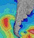 |  | 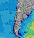 |  |  | 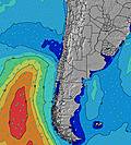 |  | ||||||||||||||
Onda Altezza (m) Direzione Periodo (s) | NNW 10 | NNW 10 | NNW 10 | NNW 10 | NNW 10 | NNW 10 | NNW 10 | NNW 9 | NNW 9 | N 9 | WNW 9 | WNW 9 | WNW 9 | WNW 10 | WNW 10 | WNW 12 | WNW 12 | WNW 11 | WNW 11 | W 11 | WNW 11 | W 11 | W 11 |
Grafico delle onde | |||||||||||||||||||||||
1088 | 1157 | 2349 | 2998 | 2540 | 2114 | 2349 | 1616 | 1151 | 412 | 424 | 370 | 378 | 511 | 482 | 953 | 966 | 750 | 634 | 545 | 469 | 396 | 389 | |
Vento (km/h) | |||||||||||||||||||||||
Stato del vento onshore cross-onshore cross-shore cross-offshore offshore piatto | cross-on | on | on | on | on | on | cross-on | on | on | on | on | on | on | cross-on | cross-on | cross-on | cross | cross-off | glassy | cross | cross-off | glassy | glassy |
Alta Marea | 12:27PM1.55m | 1:06AM1.05m | 1:12PM1.42m | 1:55AM1.06m | 1:57PM1.26m | ||||||||||||||||||
Basso Marea | 5:55AM0.10m | 7:08PM-0.01m | 6:47AM0.16m | 7:49PM0.06m | 7:42AM0.25m | 8:30PM0.14m | |||||||||||||||||
7:47 | — | — | — | — | — | — | — | 7:47 | — | — | — | — | — | — | — | 7:46 | — | — | — | — | — | — | |
— | — | — | — | 5:58 | — | — | — | — | — | — | — | 5:59 | — | — | — | — | — | — | — | 5:59 | — | — | |
mm | 6 | 12 | 3 | 1 | 1 | 3 | 5 | 8 | 6 | 3 | 1 | 1 | — | — | — | — | — | — | — | — | — | — | — |
Temp. °C | 12 | 14 | 14 | 14 | 14 | 14 | 14 | 14 | 13 | 13 | 14 | 14 | 14 | 13 | 12 | 12 | 11 | 11 | 13 | 13 | 13 | 12 | 12 |
Gelo °C | 8 | 6 | 5 | 5 | 6 | 6 | 7 | 7 | 9 | 10 | 10 | 9 | 10 | 11 | 10 | 10 | 9 | 9 | 12 | 11 | 11 | 10 | 11 |
Onda 1 Altezza (m) Direzione Periodo (s) | NNW 10 | WNW 10 | WNW 10 | SW 14 | WNW 10 | WNW 10 | SW 13 | SW 13 | SW 13 | N 9 | WNW 9 | WNW 9 | WNW 9 | WNW 10 | WNW 10 | WNW 12 | WNW 12 | WNW 11 | WNW 11 | W 11 | WNW 11 | W 11 | W 11 |
1088 | 573 | 370 | 147 | 301 | 314 | 208 | 134 | 162 | 412 | 424 | 370 | 378 | 511 | 482 | 953 | 966 | 750 | 634 | 545 | 469 | 396 | 389 | |
Onda 2 Altezza (m) Direzione Periodo (s) | WNW 10 | SW 10 | SW 9 | SW 9 | SW 13 | SW 13 | W 15 | WSW 14 | WSW 13 | WNW 9 | NNW 8 | SW 12 | SW 12 | SW 12 | N 7 | SSW 12 | SSW 11 | SSW 11 | SSW 11 | SSW 11 | SSW 11 | SSW 11 | SW 11 |
746 | 108 | 81 | 47 | 140 | 140 | 17 | 20 | 35 | 407 | 284 | 118 | 114 | 112 | 54 | 88 | 84 | 82 | 82 | 84 | 85 | 87 | 61 | |
Onda 3 Altezza (m) Direzione Periodo (s) | SW 10 | SW 14 | SW 14 | — | SW 8 | SW 8 | — | — | — | SW 12 | SW 12 | W 13 | W 12 | W 12 | W 12 | N 7 | — | N 7 | — | N 6 | — | — | NW 11 |
85 | 130 | 123 | — | 44 | 24 | — | — | — | 157 | 154 | 87 | 106 | 76 | 112 | 27 | — | 15 | — | 7 | — | — | 5 | |
onde vento Altezza (m) Direzione Periodo (s) | — | NNW 10 | NNW 10 | NNW 10 | NNW 10 | NNW 10 | NNW 10 | NNW 9 | NNW 9 | — | — | N 8 | N 8 | N 7 | — | — | — | — | — | — | — | — | — |
— | 1157 | 2349 | 2998 | 2540 | 2114 | 2349 | 1616 | 1151 | — | — | 195 | 134 | 53 | — | — | — | — | — | — | — | — | — | |
Il più vicino Offshore or Glassy | |||||||||||||||||||||||
Distanza (km) | 97 | 97 | 351 | 351 | 351 | 289 | 310 | 115 | 115 | 13 | 58 | 97 | 58 | 1 | 1 | 1 | 1 | 0 | 0 | 21 | 0 | 0 | 0 |
Migliori previsioni per le condizioni d'onda in Santiago | |||||||||||||||||||||||
Migliori previsioni per le condizioni d'onda in Chile | |||||||||||||||||||||||
Trova Onde Globale | |||||||||||||||||||||||
- Map Icons:
 Break
Break Live Wave Height (m)
 Live Wind Speed (km/h)
 Surf Rating (10 Max)
 Ocean Swells (m)
- Wind Speed (km/h)
Widget Free Surf-Forecast.com per il tuo sito
La relazione di surf / widget meteo è disponibile qui sotto per incorporare su siti esterni a titolo gratuito e fornisce una sintesi delle nostre Isla Negra previsione surf. Basta prendere il frammento di codice html da noi fornito e copiarlo nel proprio sito. È possibile scegliere la lingua preferita e unità metriche / imperiali per il feed delle previsioni surf per soddisfare le esigenze degli utenti del vostro sito .... Clicca qui per ottenere il codice.
 Nearest