
Previsioni:

Previsione a breve termineper lo più asciutto. Very mild (Max 19°C Sabato pomeriggio, Min 14°C Venerdì mattina). Vento sarà generalmente leggero. | ||||||||||||||||||||||||
Venerdì 17 | Sabato 18 | Domenica 19 | ||||||||||||||||||||||
2 AM | 5 AM | 8 AM | 11 AM | 2 PM | 5 PM | 8 PM | 11 PM | 2 AM | 5 AM | 8 AM | 11 AM | 2 PM | 5 PM | 8 PM | 11 PM | 2 AM | 5 AM | 8 AM | 11 AM | 2 PM | 5 PM | 8 PM | 11 PM | |
Mappa dell'altezza del moto ondoso |  |  |  |  | 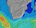 |  |  | 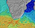 |  | |||||||||||||||
Onda Altezza (m) Direzione Periodo (s) | SW 13 | SW 13 | SW 12 | SW 12 | SW 12 | SW 11 | SW 11 | SW 11 | SW 11 | SW 10 | S 12 | SW 10 | SW 10 | SW 10 | SW 11 | SW 10 | SW 10 | SW 9 | SW 9 | SW 12 | SW 8 | SW 8 | SW 10 | SW 11 |
Grafico delle onde | ||||||||||||||||||||||||
2207 | 2555 | 2185 | 2190 | 1910 | 1481 | 1171 | 1010 | 804 | 626 | 400 | 361 | 350 | 377 | 1130 | 1219 | 777 | 508 | 402 | 319 | 427 | 1265 | 2778 | 3650 | |
Vento (km/h) | ||||||||||||||||||||||||
Stato del vento onshore cross-onshore cross-shore cross-offshore offshore piatto | off | off | off | cross-off | cross-off | cross | glassy | off | off | off | off | cross-off | cross-off | cross-off | off | off | off | off | off | cross-off | cross-off | cross-off | cross-off | cross-off |
Alta Marea | 5:32AM1.59m | 6:00PM1.69m | 6:10AM1.50m | 6:39PM1.62m | 6:48AM1.39m | 7:17PM1.51m | ||||||||||||||||||
Basso Marea | 11:31PM0.12m | 11:41AM0.04m | 00:12AM0.19m | 12:17PM0.12m | 00:52AM0.28m | 12:52PM0.23m | ||||||||||||||||||
— | 7:22 | — | — | — | — | — | — | — | 7:22 | — | — | — | — | — | — | — | 7:22 | — | — | — | — | — | — | |
— | — | — | — | — | 5:30 | — | — | — | — | — | — | — | 5:30 | — | — | — | — | — | — | — | 5:30 | — | — | |
mm | — | — | — | — | — | — | — | — | — | — | — | — | — | — | — | — | — | — | — | — | — | — | — | — |
Temp. °C | 15 | 14 | 14 | 16 | 18 | 17 | 16 | 15 | 15 | 15 | 15 | 17 | 19 | 17 | 16 | 15 | 15 | 15 | 15 | 17 | 19 | 17 | 16 | 16 |
Gelo °C | 13 | 12 | 13 | 15 | 17 | 17 | 17 | 15 | 15 | 14 | 14 | 16 | 16 | 15 | 15 | 13 | 13 | 13 | 13 | 15 | 15 | 12 | 12 | 12 |
Onda 1 Altezza (m) Direzione Periodo (s) | SW 13 | SW 13 | SW 12 | SW 12 | SW 12 | SW 11 | SW 11 | SW 11 | SW 11 | SW 10 | SW 10 | SW 10 | S 11 | S 11 | SW 11 | SW 10 | SW 10 | SW 9 | SW 9 | SW 12 | SW 12 | SE 10 | SE 10 | SE 10 |
1819 | 2088 | 2185 | 2190 | 1910 | 1481 | 1171 | 1010 | 804 | 626 | 388 | 356 | 350 | 344 | 1130 | 1219 | 777 | 508 | 402 | 295 | 244 | 134 | 115 | 196 | |
Onda 2 Altezza (m) Direzione Periodo (s) | E 11 | E 10 | E 10 | E 10 | E 10 | E 10 | E 10 | E 10 | E 10 | S 12 | S 12 | S 11 | E 10 | WSW 10 | S 11 | S 11 | SSE 11 | SW 13 | SW 13 | SSE 10 | SE 10 | SE 13 | SE 13 | S 10 |
108 | 106 | 102 | 73 | 72 | 72 | 72 | 72 | 72 | 240 | 400 | 361 | 71 | 80 | 289 | 125 | 198 | 269 | 269 | 133 | 115 | 63 | 83 | 17 | |
Onda 3 Altezza (m) Direzione Periodo (s) | — | — | — | — | — | S 14 | S 14 | S 14 | S 13 | E 10 | E 10 | E 10 | SSW 16 | E 10 | E 10 | E 10 | SW 13 | S 11 | SSE 10 | SE 10 | S 10 | SSE 10 | S 10 | E 10 |
— | — | — | — | — | 15 | 36 | 95 | 78 | 72 | 72 | 71 | 24 | 49 | 48 | 48 | 199 | 146 | 180 | 35 | 73 | 33 | 31 | 17 | |
onde vento Altezza (m) Direzione Periodo (s) | SW 13 | SW 13 | — | — | — | — | — | — | — | — | — | — | SW 10 | SW 10 | — | — | — | — | — | SW 8 | SW 8 | SW 8 | SW 10 | SW 11 |
2207 | 2555 | — | — | — | — | — | — | — | — | — | — | 348 | 377 | — | — | — | — | — | 319 | 427 | 1265 | 2778 | 3650 | |
Il più vicino Offshore or Glassy | ||||||||||||||||||||||||
Distanza (km) | 0 | 0 | 0 | 0 | 0 | 3 | 0 | 0 | 0 | 0 | 0 | 0 | 3 | 2 | 0 | 0 | 0 | 0 | 0 | 2 | 3 | 142 | 143 | 3 |
Migliori previsioni per le condizioni d'onda in Eastern Cape (South) | ||||||||||||||||||||||||
Migliori previsioni per le condizioni d'onda in South Africa | ||||||||||||||||||||||||
Trova Onde Globale | ||||||||||||||||||||||||
- Map Icons:
 Break
Break Live Wave Height (m)
 Live Wind Speed (km/h)
 Surf Rating (10 Max)
 Ocean Swells (m)
- Wind Speed (km/h)
Widget Free Surf-Forecast.com per il tuo sito
La relazione di surf / widget meteo è disponibile qui sotto per incorporare su siti esterni a titolo gratuito e fornisce una sintesi delle nostre J-Bay previsione surf. Basta prendere il frammento di codice html da noi fornito e copiarlo nel proprio sito. È possibile scegliere la lingua preferita e unità metriche / imperiali per il feed delle previsioni surf per soddisfare le esigenze degli utenti del vostro sito .... Clicca qui per ottenere il codice.
 Nearest