
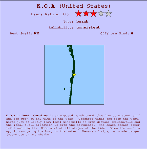
K.O.A Surf Guide
K.O.A in North Carolina is an exposed beach break that has dependable surf and can work at any time of the year. The best wind direction is from the west. Windswells and groundswells in equal measure and the ideal swell direction is from the northeast. The beach break provides left and right handers. Good surf at all stages of the tide. When the surf is up, it can get quite busy in the water. Watch out for rips, man-made danger (buoys etc...) and sharks.
K.O.A Spot Info
| Type: | Rating: | Reliability: | Todays Sea Temp*: |
|---|---|---|---|
| consistent | 26.6°C*ocean temperature recorded from satellite |
Surfing K.O.A:
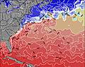
The best conditions reported for surf at K.O.A occur when a Northeast swell combines with an offshore wind direction from the West.
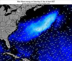
Previsioni Energia d'onda (Potenza): 12hrs
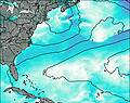

K.O.A Surf:
Saturday, 18 July 2026, 05:14 Local time| Sabato 18 | ||||
| 5AM | 8AM | 11AM | 2PM | |
| Wave (m) | ||||
| Periodo (s) | 8 | 8 | 8 | 8 |
| Vento (km/h) | ||||
| Stato del vento | cross- off |
cross- off |
cross- off |
cross- off |
- /breaks/K-O-A/forecasts/latest
K.O.A Surf Guide
K.O.A in North Carolina is an exposed beach break that has dependable surf and can work at any time of the year. The best wind direction is from the west. Windswells and groundswells in equal measure and the ideal swell direction is from the northeast. The beach break provides left and right handers. Good surf at all stages of the tide. When the surf is up, it can get quite busy in the water. Watch out for rips, man-made danger (buoys etc...) and sharks.
K.O.A Spot Info
Type: Rating: Reliability: Todays Sea Temp*:  Beach
Beach 3
3consistent 26.6°C*ocean temperature recorded from satelliteSurfing K.O.A:
The best conditions reported for surf at K.O.A occur when a Northeast swell combines with an offshore wind direction from the West.
Previsioni Energia d'onda (Potenza): 12hrs
Utilizzare la scheda di navigazione in alto per visualizzare K.O.A temperatura del mare, K.O.A fotografie, K.O.A dettagliate previsioni onde, il vento e le previsioni meteo, K.O.A webcam, vento corrente da Carolina North stazioni meteo e K.O.A previsioni marea. Il link United States mappe maree apre l'immagine grande, che mostra United States e dei mari circostanti. Queste mappe possono essere animate per mostrare le diverse componenti del moto ondoso, energia delle onde, periodo d'onda, altezza delle onde, insieme con le previsioni del vento e meteo, meteo corrente e osservazioni sullo stato del mare dal United States onda-boe, le navi passanti e stazioni meteo costiere. Ciascuna delle pagine di previsioni per questo surf break rappresenta uno strumento di wavefinder globale e regionale per individuare le migliori condizioni di surf nella zona intorno K.O.A.
K.O.A Surf:
Saturday, 18 July 2026, 05:14 Local timeSabato 18 5AM 8AM 11AM 2PM Wave (m) Periodo (s) 8 8 8 8 Vento (km/h) Stato del vento cross-
offcross-
offcross-
offcross-
off- /breaks/K-O-A/forecasts/latest
- /breaks/K-O-A/forecasts/latest/six_day
K.O.A Surf Guide
K.O.A in North Carolina is an exposed beach break that has dependable surf and can work at any time of the year. The best wind direction is from the west. Windswells and groundswells in equal measure and the ideal swell direction is from the northeast. The beach break provides left and right handers. Good surf at all stages of the tide. When the surf is up, it can get quite busy in the water. Watch out for rips, man-made danger (buoys etc...) and sharks.
K.O.A Spot Info
Type: Rating: Reliability: Todays Sea Temp*: Beach3consistent 26.6°C*ocean temperature recorded from satelliteSurfing K.O.A:
The best conditions reported for surf at K.O.A occur when a Northeast swell combines with an offshore wind direction from the West.
Previsioni Energia d'onda (Potenza): 12hrs
Utilizzare la scheda di navigazione in alto per visualizzare K.O.A temperatura del mare, K.O.A fotografie, K.O.A dettagliate previsioni onde, il vento e le previsioni meteo, K.O.A webcam, vento corrente da Carolina North stazioni meteo e K.O.A previsioni marea. Il link United States mappe maree apre l'immagine grande, che mostra United States e dei mari circostanti. Queste mappe possono essere animate per mostrare le diverse componenti del moto ondoso, energia delle onde, periodo d'onda, altezza delle onde, insieme con le previsioni del vento e meteo, meteo corrente e osservazioni sullo stato del mare dal United States onda-boe, le navi passanti e stazioni meteo costiere. Ciascuna delle pagine di previsioni per questo surf break rappresenta uno strumento di wavefinder globale e regionale per individuare le migliori condizioni di surf nella zona intorno K.O.A.
K.O.A Surf:
Saturday, 18 July 2026, 05:14 Local timeSabato 18 5AM 8AM 11AM 2PM Wave (m) Periodo (s) 8 8 8 8 Vento (km/h) Stato del vento cross-
offcross-
offcross-
offcross-
off- /breaks/K-O-A/forecasts/latest
K.O.A Surf Guide
K.O.A in North Carolina is an exposed beach break that has dependable surf and can work at any time of the year. The best wind direction is from the west. Windswells and groundswells in equal measure and the ideal swell direction is from the northeast. The beach break provides left and right handers. Good surf at all stages of the tide. When the surf is up, it can get quite busy in the water. Watch out for rips, man-made danger (buoys etc...) and sharks.
K.O.A Spot Info
Type: Rating: Reliability: Todays Sea Temp*: Beach3consistent 26.6°C*ocean temperature recorded from satelliteSurfing K.O.A:
The best conditions reported for surf at K.O.A occur when a Northeast swell combines with an offshore wind direction from the West.
Previsioni Energia d'onda (Potenza): 12hrs
Utilizzare la scheda di navigazione in alto per visualizzare K.O.A temperatura del mare, K.O.A fotografie, K.O.A dettagliate previsioni onde, il vento e le previsioni meteo, K.O.A webcam, vento corrente da Carolina North stazioni meteo e K.O.A previsioni marea. Il link United States mappe maree apre l'immagine grande, che mostra United States e dei mari circostanti. Queste mappe possono essere animate per mostrare le diverse componenti del moto ondoso, energia delle onde, periodo d'onda, altezza delle onde, insieme con le previsioni del vento e meteo, meteo corrente e osservazioni sullo stato del mare dal United States onda-boe, le navi passanti e stazioni meteo costiere. Ciascuna delle pagine di previsioni per questo surf break rappresenta uno strumento di wavefinder globale e regionale per individuare le migliori condizioni di surf nella zona intorno K.O.A.
K.O.A Surf:
Saturday, 18 July 2026, 05:14 Local timeSabato 18 5AM 8AM 11AM 2PM Wave (m) Periodo (s) 8 8 8 8 Vento (km/h) Stato del vento cross-
offcross-
offcross-
offcross-
offTide Times:
Per Rodanthe, Pamlico Sound, North Carolina, %{dist} %{km} da %{location}.
PROSSIMA È ALLE (ora locale) rimanente alta marea bassa marea K.O.A Tide Times and Tide Chart
Live Weather:
At Oregon Inlet- NC, 26 km from K.O.A.
- Air temperature
-°CBuoy Data:
At Oregon Inlet, NC, 16 miles from K.O.A.
12AM 1AM 2AM 3AM Attualità dei dati 4 hr 3 hr 2 hr 1 hr Altezza delle onde (m) 


Periodo dominante (s) 14 14 14 14 Overall K.O.A Surf Consistency and Wind Distribution in Luglio
foto dall' album
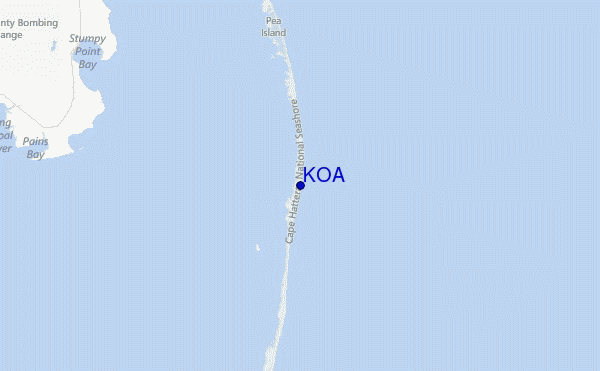
Contorni: Strade e fiumi: seleziona un surf break dal menu 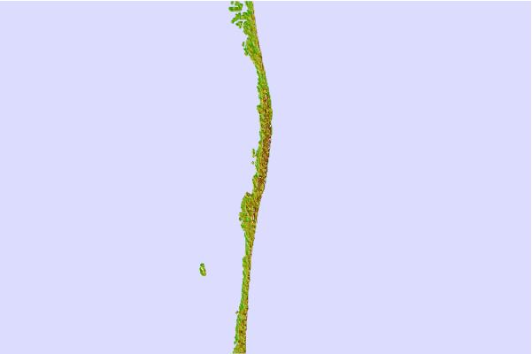

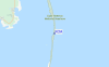
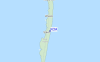
Utilizzare questa mappa sollievo per navigare Carolina North surf breaks e stazioni di marea che si trovano nella zona diK.O.A
Altri surf breaks più vicini al K.O.A:
(clicca sul nome del luogo per maggiori informazioni)- Closest località surf2 mi
- Second closest località surf4 mi
- Third closest località surf12 mi
- Fourth closest località surf13 mi
- Fifth closest località surf16 mi
Onda boe più vicina a K.O.A:
- Closest Onda boa16 mi
- Second closest Onda boa32 mi
- Third closest Onda boa37 mi
- Fourth closest Onda boa47 mi
- Fifth closest Onda boa47 mi
Stazioni di marea più vicina alla K.O.A:
- Closest marea stazioneRodanthe, Pamlico Sound4 mi
- Second closest marea stazioneAvon14 mi
- Third closest marea stazioneDavis Slough15 mi
- Fourth closest marea stazioneOregon Inlet16 mi
- Fifth closest marea stazioneOregon Inlet Bridge16 mi
Airports
- The closest passenger airport to K.O.A is Elizabeth City Cgas Rgnl Airport (ECG) in USA, 102 km (63 miles) away (directly).
- The second nearest airport to K.O.A is Cherry Point Mcas Airport (NKT), also in USA, 147 km (91 miles) away.
- Third is Oceana Nas Airport (NTU) in USA, 151 km (94 miles) away.
- Craven Co Rgnl (New Bern) Airport (EWN) in USA is 152 km (94 miles) away.
- Norfolk International Airport (ORF), also in USA is the fifth nearest airport to K.O.A and is 164 km (102 miles) away.
- /breaks/K-O-A/forecasts/latest


 Nearest