
Previsioni:

Previsione a breve termineper lo più asciutto. Very mild (Max 15°C Lunedì pomeriggio, Min 11°C mercoledì mattina). Vento sarà generalmente leggero. | |||||||||||||||||||
Dom 19 | Lunedì 20 | Martedì 21 | |||||||||||||||||
5 PM | 8 PM | 11 PM | 2 AM | 5 AM | 8 AM | 11 AM | 2 PM | 5 PM | 8 PM | 11 PM | 2 AM | 5 AM | 8 AM | 11 AM | 2 PM | 5 PM | 8 PM | 11 PM | |
Mappa dell'altezza del moto ondoso | 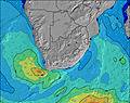 |  |  |  |  |  |  | ||||||||||||
Onda Altezza (m) Direzione Periodo (s) | SW 11 | SW 11 | SW 11 | SW 11 | SW 10 | SW 10 | SW 9 | SW 9 | SW 8 | SW 12 | SW 16 | SW 16 | SW 15 | SW 14 | SW 14 | SW 14 | SW 13 | SW 13 | SW 13 |
Grafico delle onde | |||||||||||||||||||
868 | 1100 | 1270 | 1080 | 900 | 701 | 531 | 396 | 279 | 203 | 271 | 258 | 424 | 1321 | 1895 | 2334 | 2310 | 2305 | 2114 | |
Vento (km/h) | |||||||||||||||||||
Stato del vento onshore cross-onshore cross-shore cross-offshore offshore piatto | cross-on | cross-on | cross-on | cross-on | cross-on | cross | cross-on | on | on | on | glassy | glassy | cross-off | glassy | off | cross-off | cross-off | cross-off | off |
Alta Marea | 7:01PM1.42m | 7:23AM1.17m | 7:45PM1.31m | 8:15AM1.07m | 8:37PM1.19m | ||||||||||||||
Basso Marea | 1:24AM0.33m | 1:21PM0.39m | 2:14AM0.43m | 2:09PM0.51m | |||||||||||||||
— | — | — | — | 7:46 | — | — | — | — | — | — | — | 7:46 | — | — | — | — | — | — | |
5:57 | — | — | — | — | — | — | — | 5:58 | — | — | — | — | — | — | — | 5:59 | — | — | |
mm | — | — | — | — | — | — | — | — | — | — | — | — | — | — | — | — | — | — | — |
Temp. °C | 15 | 14 | 14 | 13 | 12 | 12 | 14 | 15 | 15 | 14 | 13 | 12 | 12 | 12 | 13 | 15 | 15 | 13 | 12 |
Gelo °C | 14 | 13 | 13 | 11 | 10 | 10 | 12 | 13 | 13 | 12 | 12 | 11 | 11 | 11 | 12 | 13 | 13 | 11 | 11 |
Onda 1 Altezza (m) Direzione Periodo (s) | SW 11 | SW 11 | SW 11 | SW 11 | SW 10 | SW 10 | SW 9 | SW 9 | SW 8 | SW 8 | SSW 8 | SW 8 | SW 15 | SW 14 | SW 14 | SW 14 | SW 13 | SW 13 | SW 13 |
868 | 1100 | 1270 | 1080 | 900 | 701 | 531 | 396 | 279 | 129 | 109 | 84 | 424 | 1321 | 1895 | 2334 | 2310 | 2305 | 2114 | |
Onda 2 Altezza (m) Direzione Periodo (s) | W 10 | W 10 | W 10 | W 10 | W 10 | W 10 | W 10 | W 10 | W 10 | SW 12 | SW 16 | SW 16 | SW 7 | W 9 | W 9 | W 9 | W 9 | — | — |
100 | 125 | 121 | 153 | 94 | 94 | 116 | 121 | 90 | 203 | 271 | 258 | 77 | 39 | 39 | 25 | 24 | — | — | |
Onda 3 Altezza (m) Direzione Periodo (s) | SSE 10 | SSE 10 | SSE 10 | SSE 10 | S 9 | S 9 | S 9 | S 9 | SW 18 | W 10 | W 10 | SW 12 | SW 11 | SW 11 | WSW 11 | — | — | — | — |
19 | 18 | 18 | 9 | 7 | 6 | 6 | 6 | 50 | 89 | 89 | 120 | 150 | 31 | 12 | — | — | — | — | |
onde vento Altezza (m) Direzione Periodo (s) | — | — | — | — | — | — | — | NNW 2 | — | — | — | — | — | — | — | — | — | — | — |
— | — | — | — | — | — | — | 1 | — | — | — | — | — | — | — | — | — | — | — | |
Il più vicino Offshore or Glassy | |||||||||||||||||||
Distanza (km) | 29 | 2 | 2 | 2 | 2 | 2 | 2 | 29 | 29 | 4 | 0 | 0 | 0 | 0 | 0 | 0 | 0 | 0 | 0 |
Migliori previsioni per le condizioni d'onda in Cape Town | |||||||||||||||||||
Migliori previsioni per le condizioni d'onda in South Africa | |||||||||||||||||||
Trova Onde Globale | |||||||||||||||||||
- Map Icons:
 Break
Break Live Wave Height (m)
 Live Wind Speed (km/h)
 Surf Rating (10 Max)
 Ocean Swells (m)
- Wind Speed (km/h)
Widget Free Surf-Forecast.com per il tuo sito
La relazione di surf / widget meteo è disponibile qui sotto per incorporare su siti esterni a titolo gratuito e fornisce una sintesi delle nostre Kamer Van previsione surf. Basta prendere il frammento di codice html da noi fornito e copiarlo nel proprio sito. È possibile scegliere la lingua preferita e unità metriche / imperiali per il feed delle previsioni surf per soddisfare le esigenze degli utenti del vostro sito .... Clicca qui per ottenere il codice.
 Nearest