
Previsioni:

Previsione a breve termineper lo più asciutto. Warm (Max 27°C mercoledì notte, Min 16°C Venerdì notte). Venti in aumento (venti deboli da SSW mercoledì mattina, venti freschi da NNE per venerdì pomeriggio). | ||||||||||||||||||||||||
Mercoledì 29 | Giovedì 30 | Venerdì 31 | ||||||||||||||||||||||
2 AM | 5 AM | 8 AM | 11 AM | 2 PM | 5 PM | 8 PM | 11 PM | 2 AM | 5 AM | 8 AM | 11 AM | 2 PM | 5 PM | 8 PM | 11 PM | 2 AM | 5 AM | 8 AM | 11 AM | 2 PM | 5 PM | 8 PM | 11 PM | |
Mappa dell'altezza del moto ondoso |  | 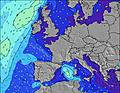 |  |  |  |  |  |  |  | |||||||||||||||
Onda Altezza (m) Direzione Periodo (s) | NNW 9 | NNW 9 | NNW 9 | NNW 9 | NNW 9 | NNW 10 | NNW 9 | NNW 9 | NNW 9 | NNW 9 | NNW 8 | NNW 8 | NNW 8 | WNW 4 | NNW 8 | WNW 4 | NNW 8 | NNW 8 | NNW 8 | NNW 8 | NW 5 | NNW 7 | NW 7 | NNW 6 |
Grafico delle onde | ||||||||||||||||||||||||
45 | 45 | 31 | 26 | 26 | 31 | 29 | 28 | 26 | 26 | 24 | 23 | 23 | 20 | 16 | 13 | 13 | 12 | 6 | 6 | 7 | 19 | 21 | 27 | |
Vento (km/h) | ||||||||||||||||||||||||
Stato del vento onshore cross-onshore cross-shore cross-offshore offshore piatto | cross-off | cross-off | cross-off | cross-off | cross-off | cross-on | cross-off | off | cross-off | cross | cross-on | on | on | cross-on | on | cross-on | cross-off | cross-off | cross-off | cross-off | cross | cross | cross | cross-on |
Alta Marea | 8:32AM2.13m | 6:51PM1.78m | 8:57PM1.82m | 9:13AM2.18m | 7:36PM1.78m | 9:36PM1.83m | 9:46AM2.23m | 10:09PM1.84m | ||||||||||||||||
Basso Marea | 2:23AM0.43m | 3:01PM0.42m | 7:26PM1.78m | 3:05AM0.40m | 3:43PM0.38m | 7:49PM1.78m | 3:42AM0.37m | 4:21PM0.34m | ||||||||||||||||
— | 5:52 | — | — | — | — | — | — | — | 5:54 | — | — | — | — | — | — | — | 5:54 | — | — | — | — | — | — | |
— | — | — | — | — | — | 9:40 | — | — | — | — | — | — | — | 9:38 | — | — | — | — | — | — | — | 9:37 | — | |
mm | — | — | — | — | — | — | — | — | — | — | — | — | — | — | — | — | — | — | — | — | — | — | — | — |
Temp. °C | 23 | 22 | 22 | 23 | 23 | 24 | 26 | 27 | 25 | 21 | 19 | 19 | 19 | 18 | 18 | 19 | 18 | 18 | 17 | 18 | 18 | 17 | 17 | 17 |
Gelo °C | 21 | 20 | 21 | 22 | 22 | 23 | 24 | 24 | 22 | 17 | 16 | 17 | 18 | 17 | 17 | 18 | 16 | 17 | 15 | 16 | 14 | 11 | 12 | 13 |
Onda 1 Altezza (m) Direzione Periodo (s) | NNW 9 | NNW 9 | NNW 9 | NNW 9 | NNW 9 | NNW 10 | NNW 9 | NNW 9 | NNW 9 | NNW 9 | NNW 8 | NNW 8 | NNW 8 | NNW 8 | NNW 8 | WNW 4 | WNW 4 | WNW 4 | NNW 5 | NNW 5 | NW 5 | NNW 7 | NW 7 | NNW 6 |
45 | 45 | 31 | 26 | 26 | 31 | 29 | 28 | 26 | 26 | 24 | 23 | 23 | 13 | 13 | 12 | 6 | 4 | 5 | 5 | 7 | 19 | 21 | 27 | |
Onda 2 Altezza (m) Direzione Periodo (s) | — | — | SW 4 | WSW 4 | WSW 4 | WSW 4 | SW 4 | NW 4 | — | — | — | — | — | — | SW 5 | NNW 8 | NNW 5 | NNW 5 | WNW 4 | NNW 8 | NNW 7 | SSW 5 | SW 5 | SW 5 |
— | — | 4 | 3 | 1 | 1 | 1 | 1 | — | — | — | — | — | — | 3 | 13 | 4 | 5 | 2 | 6 | 5 | 2 | 1 | 1 | |
Onda 3 Altezza (m) Direzione Periodo (s) | — | — | WNW 4 | N 11 | — | NW 5 | NW 4 | — | — | — | — | — | — | — | — | SW 4 | NNW 8 | NNW 8 | NNW 8 | WNW 4 | SW 5 | — | — | — |
— | — | 2 | 2 | — | 1 | 1 | — | — | — | — | — | — | — | — | 3 | 13 | 12 | 6 | 2 | 4 | — | — | — | |
onde vento Altezza (m) Direzione Periodo (s) | SW 4 | SW 4 | — | — | — | — | — | — | SE 3 | SSW 3 | WSW 4 | WSW 4 | W 4 | WNW 4 | NW 4 | — | — | — | — | ESE 2 | ENE 3 | NE 3 | NE 4 | NNE 4 |
7 | 6 | — | — | — | — | — | — | 2 | 3 | 22 | 21 | 18 | 20 | 16 | — | — | — | — | 1 | 1 | 9 | 11 | 9 | |
Il più vicino Offshore or Glassy | ||||||||||||||||||||||||
Distanza (km) | 0 | 0 | 140 | 499 | 658 | 728 | 728 | 618 | 763 | 638 | 566 | 766 | 816 | 788 | 838 | 763 | 771 | 685 | 730 | 777 | 796 | 2066 | 1933 | 795 |
Migliori previsioni per le condizioni d'onda in Netherlands | ||||||||||||||||||||||||
Migliori previsioni per le condizioni d'onda in Netherlands | ||||||||||||||||||||||||
Trova Onde Globale | ||||||||||||||||||||||||
- Map Icons:
 Break
Break Live Wave Height (m)
 Live Wind Speed (km/h)
 Surf Rating (10 Max)
 Ocean Swells (m)
- Wind Speed (km/h)
Widget Free Surf-Forecast.com per il tuo sito
La relazione di surf / widget meteo è disponibile qui sotto per incorporare su siti esterni a titolo gratuito e fornisce una sintesi delle nostre Kogerstrand (De Koog) previsione surf. Basta prendere il frammento di codice html da noi fornito e copiarlo nel proprio sito. È possibile scegliere la lingua preferita e unità metriche / imperiali per il feed delle previsioni surf per soddisfare le esigenze degli utenti del vostro sito .... Clicca qui per ottenere il codice.
 Nearest