
Previsioni:

Previsione a breve terminePioggia moderata (Totale 15mm), più pesante Sabato notte. Warm (Max 26°C martedì mattina, Min 18°C Lunedì notte). Venti decrescenti (venti freschi da O Sabato pomeriggio, calma per lunedì mattina). | |||||||||||||||||||||
25 | Domenica 26 | Lunedì 27 | |||||||||||||||||||
11 AM | 2 PM | 5 PM | 8 PM | 11 PM | 2 AM | 5 AM | 8 AM | 11 AM | 2 PM | 5 PM | 8 PM | 11 PM | 2 AM | 5 AM | 8 AM | 11 AM | 2 PM | 5 PM | 8 PM | 11 PM | |
Mappa dell'altezza del moto ondoso | 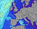 |  |  |  |  |  |  |  | |||||||||||||
Onda Altezza (m) Direzione Periodo (s) | W 6 | WNW 6 | WNW 7 | WNW 7 | NW 7 | NW 7 | NW 7 | NW 7 | NW 7 | NW 7 | NW 7 | NW 6 | NW 6 | NW 6 | NW 7 | NW 7 | NW 11 | NW 10 | NW 10 | NW 10 | NW 10 |
Grafico delle onde | |||||||||||||||||||||
175 | 293 | 385 | 323 | 344 | 412 | 353 | 285 | 206 | 164 | 143 | 116 | 88 | 91 | 131 | 121 | 162 | 392 | 369 | 361 | 361 | |
Vento (km/h) | |||||||||||||||||||||
Stato del vento onshore cross-onshore cross-shore cross-offshore offshore piatto | on | on | on | cross-on | cross-on | cross-on | cross-on | on | cross-on | cross-on | cross-on | on | on | on | cross-on | on | glassy | cross | cross | cross | cross |
Alta Marea | 2:53PM2.86m | 3:25AM2.82m | 3:44PM3.02m | 4:11AM2.97m | 4:26PM3.21m | ||||||||||||||||
Basso Marea | 8:20AM1.23m | 8:57PM1.11m | 9:16AM1.10m | 9:48PM0.94m | 10:02AM0.93m | 10:31PM0.76m | |||||||||||||||
— | — | — | — | — | — | 6:47 | — | — | — | — | — | — | — | 6:48 | — | — | — | — | — | — | |
— | — | — | 9:37 | — | — | — | — | — | — | — | 9:36 | — | — | — | — | — | — | — | 9:35 | — | |
mm | — | — | 1 | 4 | 3 | 3 | 1 | — | 1 | — | — | — | — | — | — | 1 | 1 | — | — | — | — |
Temp. °C | 22 | 22 | 22 | 21 | 21 | 20 | 20 | 20 | 21 | 21 | 22 | 21 | 21 | 20 | 20 | 20 | 20 | 21 | 21 | 21 | 20 |
Gelo °C | 18 | 18 | 19 | 19 | 19 | 18 | 18 | 18 | 19 | 19 | 20 | 20 | 21 | 20 | 20 | 21 | 23 | 22 | 20 | 21 | 21 |
Onda 1 Altezza (m) Direzione Periodo (s) | W 12 | W 12 | — | NW 11 | — | — | — | NW 7 | NW 7 | NW 10 | WNW 10 | NW 6 | NW 6 | NW 6 | NW 7 | NW 7 | NW 7 | NW 10 | NW 10 | NW 10 | NW 10 |
3 | 3 | — | 5 | — | — | — | 285 | 206 | 4 | 9 | 116 | 88 | 91 | 131 | 121 | 130 | 392 | 369 | 361 | 361 | |
Onda 2 Altezza (m) Direzione Periodo (s) | — | — | — | — | — | — | — | — | — | — | NW 12 | WNW 9 | WNW 9 | NW 12 | NW 11 | NW 11 | NW 11 | — | — | — | — |
— | — | — | — | — | — | — | — | — | — | 6 | 8 | 8 | 21 | 46 | 77 | 162 | — | — | — | — | |
Onda 3 Altezza (m) Direzione Periodo (s) | — | — | — | — | — | — | — | — | — | — | — | NW 12 | NW 12 | WNW 9 | — | — | — | — | — | — | — |
— | — | — | — | — | — | — | — | — | — | — | 6 | 23 | 8 | — | — | — | — | — | — | — | |
onde vento Altezza (m) Direzione Periodo (s) | W 6 | WNW 6 | WNW 7 | WNW 7 | NW 7 | NW 7 | NW 7 | — | — | NW 7 | NW 7 | — | — | — | — | — | — | — | — | — | — |
175 | 293 | 385 | 323 | 344 | 412 | 353 | — | — | 164 | 143 | — | — | — | — | — | — | — | — | — | — | |
Il più vicino Offshore or Glassy | |||||||||||||||||||||
Distanza (km) | 182 | 149 | 317 | 163 | 163 | 163 | 163 | 73 | 163 | 350 | 211 | 40 | 41 | 41 | 40 | 40 | 0 | 104 | 104 | 38 | 0 |
Migliori previsioni per le condizioni d'onda in Landes | |||||||||||||||||||||
Migliori previsioni per le condizioni d'onda in France | |||||||||||||||||||||
Trova Onde Globale | |||||||||||||||||||||
- Map Icons:
 Break
Break Live Wave Height (m)
 Live Wind Speed (km/h)
 Surf Rating (10 Max)
 Ocean Swells (m)
- Wind Speed (km/h)
Widget Free Surf-Forecast.com per il tuo sito
La relazione di surf / widget meteo è disponibile qui sotto per incorporare su siti esterni a titolo gratuito e fornisce una sintesi delle nostre Hossegor - La Centrale previsione surf. Basta prendere il frammento di codice html da noi fornito e copiarlo nel proprio sito. È possibile scegliere la lingua preferita e unità metriche / imperiali per il feed delle previsioni surf per soddisfare le esigenze degli utenti del vostro sito .... Clicca qui per ottenere il codice.
 Nearest