
La Cienega Surf Guide
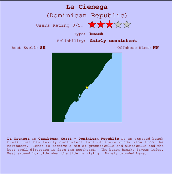
La Cienega on the South Coast is an exposed beach break that has quite reliable surf The best wind direction is from the northwest. Tends to receive a mix of groundswells and windswells and the best swell direction is from the southeast. Waves at the beach tend to peel to the left. Best around low tide when the tide is rising. Rarely crowded here.
La Cienega Spot Info
| Type: | Rating: | Reliability: | Todays Sea Temp*: |
|---|---|---|---|
| fairly consistent | 28.9°C*ocean temperature recorded from satellite |
Surfing La Cienega:
The best conditions reported for surf at La Cienega occur when a Southeast swell combines with an offshore wind direction from the Northwest.

Previsioni Energia d'onda (Potenza): 12hrs


La Cienega Surf:
Saturday, 25 July 2026, 16:26 Local time| Sabato 25 | Dom | |||
| 5PM | 8PM | 11PM | 2AM | |
| Wave (m) | ||||
| Periodo (s) | 7 | 7 | 7 | 7 |
| Vento (km/h) | ||||
| Stato del vento | cross- on |
cross | cross | cross |
- /breaks/La-Cienega/forecasts/latest
La Cienega Surf Guide
La Cienega on the South Coast is an exposed beach break that has quite reliable surf The best wind direction is from the northwest. Tends to receive a mix of groundswells and windswells and the best swell direction is from the southeast. Waves at the beach tend to peel to the left. Best around low tide when the tide is rising. Rarely crowded here.
La Cienega Spot Info
Type: Rating: Reliability: Todays Sea Temp*:  Beach
Beach 3
3fairly consistent 28.9°C*ocean temperature recorded from satelliteSurfing La Cienega:
The best conditions reported for surf at La Cienega occur when a Southeast swell combines with an offshore wind direction from the Northwest.
Previsioni Energia d'onda (Potenza): 12hrs
Utilizzare la scheda di navigazione in alto per visualizzare La Cienega temperatura del mare, La Cienega fotografie, La Cienega dettagliate previsioni onde, il vento e le previsioni meteo, La Cienega webcam, vento corrente da Caribbean Coast stazioni meteo e La Cienega previsioni marea. Il link Dominican Republic mappe maree apre l'immagine grande, che mostra Dominican Republic e dei mari circostanti. Queste mappe possono essere animate per mostrare le diverse componenti del moto ondoso, energia delle onde, periodo d'onda, altezza delle onde, insieme con le previsioni del vento e meteo, meteo corrente e osservazioni sullo stato del mare dal Dominican Republic onda-boe, le navi passanti e stazioni meteo costiere. Ciascuna delle pagine di previsioni per questo surf break rappresenta uno strumento di wavefinder globale e regionale per individuare le migliori condizioni di surf nella zona intorno La Cienega.
La Cienega Surf:
Saturday, 25 July 2026, 16:26 Local timeSabato 25 Dom 5PM 8PM 11PM 2AM Wave (m) Periodo (s) 7 7 7 7 Vento (km/h) Stato del vento cross-
oncross cross cross - /breaks/La-Cienega/forecasts/latest
- /breaks/La-Cienega/forecasts/latest/six_day
La Cienega Surf Guide
La Cienega on the South Coast is an exposed beach break that has quite reliable surf The best wind direction is from the northwest. Tends to receive a mix of groundswells and windswells and the best swell direction is from the southeast. Waves at the beach tend to peel to the left. Best around low tide when the tide is rising. Rarely crowded here.
La Cienega Spot Info
Type: Rating: Reliability: Todays Sea Temp*: Beach3fairly consistent 28.9°C*ocean temperature recorded from satelliteSurfing La Cienega:
The best conditions reported for surf at La Cienega occur when a Southeast swell combines with an offshore wind direction from the Northwest.
Previsioni Energia d'onda (Potenza): 12hrs
Utilizzare la scheda di navigazione in alto per visualizzare La Cienega temperatura del mare, La Cienega fotografie, La Cienega dettagliate previsioni onde, il vento e le previsioni meteo, La Cienega webcam, vento corrente da Caribbean Coast stazioni meteo e La Cienega previsioni marea. Il link Dominican Republic mappe maree apre l'immagine grande, che mostra Dominican Republic e dei mari circostanti. Queste mappe possono essere animate per mostrare le diverse componenti del moto ondoso, energia delle onde, periodo d'onda, altezza delle onde, insieme con le previsioni del vento e meteo, meteo corrente e osservazioni sullo stato del mare dal Dominican Republic onda-boe, le navi passanti e stazioni meteo costiere. Ciascuna delle pagine di previsioni per questo surf break rappresenta uno strumento di wavefinder globale e regionale per individuare le migliori condizioni di surf nella zona intorno La Cienega.
La Cienega Surf:
Saturday, 25 July 2026, 16:26 Local timeSabato 25 Dom 5PM 8PM 11PM 2AM Wave (m) Periodo (s) 7 7 7 7 Vento (km/h) Stato del vento cross-
oncross cross cross - /breaks/La-Cienega/forecasts/latest
La Cienega Surf Guide
La Cienega on the South Coast is an exposed beach break that has quite reliable surf The best wind direction is from the northwest. Tends to receive a mix of groundswells and windswells and the best swell direction is from the southeast. Waves at the beach tend to peel to the left. Best around low tide when the tide is rising. Rarely crowded here.
La Cienega Spot Info
Type: Rating: Reliability: Todays Sea Temp*: Beach3fairly consistent 28.9°C*ocean temperature recorded from satelliteSurfing La Cienega:
The best conditions reported for surf at La Cienega occur when a Southeast swell combines with an offshore wind direction from the Northwest.
Previsioni Energia d'onda (Potenza): 12hrs
Utilizzare la scheda di navigazione in alto per visualizzare La Cienega temperatura del mare, La Cienega fotografie, La Cienega dettagliate previsioni onde, il vento e le previsioni meteo, La Cienega webcam, vento corrente da Caribbean Coast stazioni meteo e La Cienega previsioni marea. Il link Dominican Republic mappe maree apre l'immagine grande, che mostra Dominican Republic e dei mari circostanti. Queste mappe possono essere animate per mostrare le diverse componenti del moto ondoso, energia delle onde, periodo d'onda, altezza delle onde, insieme con le previsioni del vento e meteo, meteo corrente e osservazioni sullo stato del mare dal Dominican Republic onda-boe, le navi passanti e stazioni meteo costiere. Ciascuna delle pagine di previsioni per questo surf break rappresenta uno strumento di wavefinder globale e regionale per individuare le migliori condizioni di surf nella zona intorno La Cienega.
La Cienega Surf:
Saturday, 25 July 2026, 16:26 Local timeSabato 25 Dom 5PM 8PM 11PM 2AM Wave (m) Periodo (s) 7 7 7 7 Vento (km/h) Stato del vento cross-
oncross cross cross Tide Times:
Per Enriquillo, %{dist} %{km} da %{location}.
PROSSIMA È ALLE (ora locale) rimanente alta marea bassa marea La Cienega Tide Times and Tide Chart
Live Weather:
At Barahona Airport, 39 km from La Cienega.
fresh winds from the SE
(km/h)Air temperature
33°COverall La Cienega Surf Consistency and Wind Distribution in Luglio
foto dall' album
Contorni: Strade e fiumi: seleziona un surf break dal menu 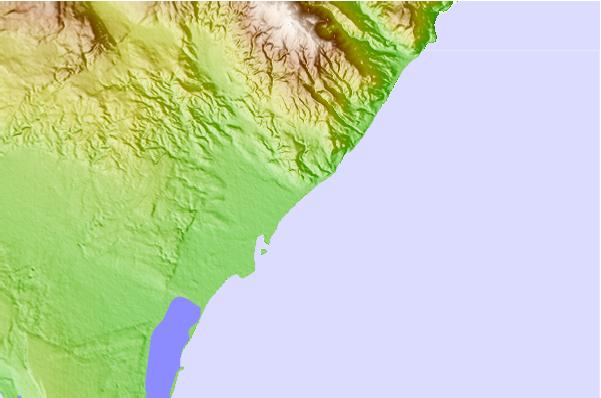
Utilizzare questa mappa sollievo per navigare Caribbean Coast surf breaks e stazioni di marea che si trovano nella zona diLa Cienega
Altri surf breaks più vicini al La Cienega:
(clicca sul nome del luogo per maggiori informazioni)- Closest località surf6 mi
- Second closest località surf7 mi
- Third closest località surf10 mi
- Fourth closest località surf18 mi
- Fifth closest località surf21 mi
Onda boe più vicina a La Cienega:
- Closest Onda boa263 mi
- Second closest Onda boa311 mi
- Third closest Onda boa341 mi
- Fourth closest Onda boa382 mi
- Fifth closest Onda boa415 mi
Stazioni di marea più vicina alla La Cienega:
- Closest marea stazioneEnriquillo2 mi
- Second closest marea stazioneParaiso10 mi
- Third closest marea stazioneBarahona25 mi
- Fourth closest marea stazionePedernales34 mi
- Fifth closest marea stazionePaya68 mi
Airports
- The closest passenger airport to La Cienega is Maria Montez International (Barahona) Airport (BRX) in Dominican Republic, 43 km (27 miles) away (directly).
- The second nearest airport to La Cienega is Port Au Prince International (Port-au-prince) Airport (PAP) in Haiti, 135 km (84 miles) away.
- Third is Herrera International (Santo Domingo) Airport (HEX) in Dominican Republic, 151 km (94 miles) away.
- Las Americas International (Santo Domingo) Airport (SDQ) in Dominican Republic is 178 km (111 miles) away.
- Cibao International (Santiago) Airport (STI), also in Dominican Republic is the fifth nearest airport to La Cienega and is 183 km (114 miles) away.
- /breaks/La-Cienega/forecasts/latest


 Nearest