
Previsioni:

Previsione a breve terminePioggia abbondante (Totale 147mm), più pesante durante mercoledì pomeriggio. Very mild (Max 14°C mercoledì notte, Min 11°C giovedì notte). Venti decrescenti (Burrasca da NNE giovedì pomeriggio, calma per giovedì notte). | ||||||||||||||||||||||||
Mer 15 | Giovedì 16 | Venerdì 17 | 18 | |||||||||||||||||||||
11 AM | 2 PM | 5 PM | 8 PM | 11 PM | 2 AM | 5 AM | 8 AM | 11 AM | 2 PM | 5 PM | 8 PM | 11 PM | 2 AM | 5 AM | 8 AM | 11 AM | 2 PM | 5 PM | 8 PM | 11 PM | 2 AM | 5 AM | 8 AM | |
Mappa dell'altezza del moto ondoso |  |  | 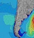 | 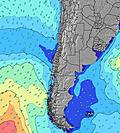 |  |  | 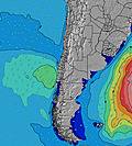 | 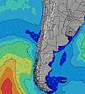 |  | |||||||||||||||
Onda Altezza (m) Direzione Periodo (s) | WNW 10 | WNW 10 | N 7 | N 7 | N 7 | N 7 | N 8 | N 9 | N 10 | NNW 11 | NNW 11 | N 10 | NW 11 | NW 10 | NW 10 | NW 10 | SW 13 | NW 10 | NW 9 | SW 13 | SW 13 | SW 13 | SW 12 | SW 12 |
Grafico delle onde | ||||||||||||||||||||||||
282 | 240 | 321 | 481 | 538 | 762 | 1669 | 3159 | 5426 | 7160 | 4921 | 1838 | 1210 | 951 | 665 | 511 | 495 | 451 | 414 | 380 | 343 | 321 | 301 | 253 | |
Vento (km/h) | ||||||||||||||||||||||||
Stato del vento onshore cross-onshore cross-shore cross-offshore offshore piatto | cross | cross | cross | cross | cross | cross | cross | cross | cross | cross | cross | cross-on | glassy | glassy | glassy | glassy | glassy | cross | cross | cross-off | cross | cross | cross-on | cross |
Alta Marea | 11:11AM1.73m | 11:49PM1.04m | 11:58AM1.69m | 00:36AM1.07m | 12:44PM1.60m | 1:23AM1.09m | ||||||||||||||||||
Basso Marea | 5:58PM-0.07m | 5:22AM0.08m | 6:42PM-0.05m | 6:12AM0.11m | 7:24PM-0.00m | 7:04AM0.17m | ||||||||||||||||||
— | — | — | — | — | — | 7:56 | — | — | — | — | — | — | — | 7:56 | — | — | — | — | — | — | — | 7:56 | — | |
— | — | 5:54 | — | — | — | — | — | — | — | 5:55 | — | — | — | — | — | — | — | 5:55 | — | — | — | — | 5:57 | |
mm | 8 | 15 | 17 | 9 | 3 | 3 | 8 | 5 | 12 | 17 | 11 | 6 | 3 | 2 | 6 | 4 | 1 | 2 | 3 | 1 | 7 | 8 | 1 | 1 |
Temp. °C | 13 | 13 | 13 | 14 | 14 | 14 | 14 | 14 | 13 | 12 | 13 | 13 | 12 | 11 | 11 | 11 | 12 | 13 | 12 | 12 | 11 | 11 | 11 | 11 |
Gelo °C | 10 | 8 | 8 | 8 | 8 | 6 | 4 | 3 | 0 | -1 | 3 | 7 | 12 | 10 | 11 | 11 | 12 | 12 | 10 | 10 | 9 | 9 | 8 | 8 |
Onda 1 Altezza (m) Direzione Periodo (s) | WNW 10 | WNW 10 | W 10 | W 9 | W 9 | W 9 | SW 12 | SW 12 | SW 16 | SW 16 | NNW 11 | N 10 | NW 11 | NW 10 | NW 10 | N 9 | NW 9 | NW 10 | NW 9 | N 9 | NW 9 | NW 9 | NW 9 | NW 9 |
282 | 240 | 268 | 162 | 159 | 103 | 134 | 83 | 169 | 302 | 4921 | 1838 | 1210 | 951 | 665 | 471 | 456 | 398 | 414 | 367 | 343 | 258 | 278 | 253 | |
Onda 2 Altezza (m) Direzione Periodo (s) | WSW 10 | SW 10 | SW 12 | SW 12 | SW 12 | SW 12 | W 9 | SW 17 | SW 11 | SW 11 | SW 16 | NW 11 | N 10 | N 10 | N 9 | NW 10 | N 9 | N 9 | N 9 | NW 9 | N 9 | SW 13 | SW 12 | SW 12 |
125 | 142 | 132 | 134 | 137 | 134 | 57 | 102 | 45 | 20 | 236 | 1403 | 1109 | 725 | 549 | 480 | 365 | 357 | 359 | 343 | 313 | 321 | 301 | 212 | |
Onda 3 Altezza (m) Direzione Periodo (s) | SW 12 | SW 12 | WNW 8 | WNW 8 | WNW 8 | SW 17 | SW 17 | — | — | — | SW 11 | SW 15 | SW 14 | SW 14 | SW 14 | SW 13 | SW 13 | SW 13 | SW 13 | SW 13 | SW 13 | WSW 13 | WSW 13 | W 13 |
72 | 74 | 7 | 7 | 7 | 44 | 47 | — | — | — | 43 | 421 | 466 | 632 | 534 | 511 | 495 | 451 | 386 | 380 | 326 | 59 | 59 | 89 | |
onde vento Altezza (m) Direzione Periodo (s) | N 7 | N 7 | N 7 | N 7 | N 7 | N 7 | N 8 | N 9 | N 10 | NNW 11 | — | — | — | — | — | — | — | — | — | — | — | N 9 | N 8 | N 8 |
179 | 173 | 321 | 481 | 538 | 762 | 1669 | 3159 | 5426 | 7160 | — | — | — | — | — | — | — | — | — | — | — | 299 | 279 | 230 | |
Il più vicino Offshore or Glassy | ||||||||||||||||||||||||
Distanza (km) | 347 | 347 | 289 | 229 | 174 | 386 | 358 | 375 | 1273 | 206 | 135 | 135 | 0 | 0 | 0 | 0 | 0 | 62 | 62 | 0 | 21 | 62 | 206 | 206 |
Migliori previsioni per le condizioni d'onda in Concepcion | ||||||||||||||||||||||||
Migliori previsioni per le condizioni d'onda in Chile | ||||||||||||||||||||||||
Trova Onde Globale | ||||||||||||||||||||||||
- Map Icons:
 Break
Break Live Wave Height (m)
 Live Wind Speed (km/h)
 Surf Rating (10 Max)
 Ocean Swells (m)
- Wind Speed (km/h)
Widget Free Surf-Forecast.com per il tuo sito
La relazione di surf / widget meteo è disponibile qui sotto per incorporare su siti esterni a titolo gratuito e fornisce una sintesi delle nostre La Gotera previsione surf. Basta prendere il frammento di codice html da noi fornito e copiarlo nel proprio sito. È possibile scegliere la lingua preferita e unità metriche / imperiali per il feed delle previsioni surf per soddisfare le esigenze degli utenti del vostro sito .... Clicca qui per ottenere il codice.
 Nearest