
Previsioni:

Previsione a breve termineper lo più asciutto. Warm (Max 25°C mercoledì pomeriggio, Min 24°C mercoledì pomeriggio). Vento sarà generalmente leggero. | ||||||||||||||||||||||||
Mer 15 | Giovedì 16 | Venerdì 17 | 18 | |||||||||||||||||||||
3 PM | 6 PM | 9 PM | 12 AM | 3 AM | 6 AM | 9 AM | 12 PM | 3 PM | 6 PM | 9 PM | 12 AM | 3 AM | 6 AM | 9 AM | 12 PM | 3 PM | 6 PM | 9 PM | 12 AM | 3 AM | 6 AM | 9 AM | 12 PM | |
Mappa dell'altezza del moto ondoso | 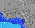 | 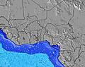 | 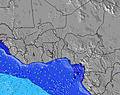 | 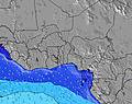 | 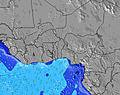 | 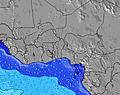 | 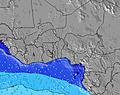 | 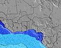 | 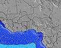 | |||||||||||||||
Onda Altezza (m) Direzione Periodo (s) | S 7 | S 6 | S 6 | S 6 | SSW 19 | SSW 19 | SSW 16 | SSW 16 | SSW 16 | SSW 17 | SSW 18 | SSW 18 | SSW 15 | SSW 17 | SSW 14 | SSW 16 | SSW 16 | SSW 16 | SSW 16 | SSW 15 | SSW 15 | SSW 15 | SSW 15 | SSW 14 |
Grafico delle onde | ||||||||||||||||||||||||
196 | 166 | 139 | 139 | 146 | 214 | 148 | 144 | 232 | 344 | 480 | 273 | 204 | 469 | 211 | 481 | 481 | 575 | 392 | 445 | 411 | 498 | 485 | 384 | |
Vento (km/h) | ||||||||||||||||||||||||
Stato del vento onshore cross-onshore cross-shore cross-offshore offshore piatto | on | on | on | on | on | on | on | cross-on | cross-on | cross-on | on | on | cross-on | cross-on | cross-on | cross-on | cross-on | cross-on | on | on | cross-on | cross-on | cross-on | cross-on |
Alta Marea | 5:35PM1.03m | 6:37AM1.09m | 6:22PM1.01m | 7:18AM1.08m | 7:08PM0.98m | 7:58AM1.06m | ||||||||||||||||||
Basso Marea | 11:42PM0.23m | 12:12PM0.45m | 00:25AM0.26m | 12:59PM0.45m | 1:08AM0.31m | |||||||||||||||||||
— | — | — | — | — | 6:09 | — | — | — | — | — | — | — | 6:09 | — | — | — | — | — | — | — | 6:09 | — | — | |
— | 6:32 | — | — | — | — | — | — | — | 6:32 | — | — | — | — | — | — | — | 6:32 | — | — | — | — | — | 6:32 | |
mm | — | — | — | — | — | — | — | — | — | — | — | — | — | — | — | — | — | — | — | — | — | — | — | — |
Temp. °C | 25 | 24 | 24 | 24 | 24 | 24 | 24 | 25 | 24 | 24 | 24 | 24 | 24 | 24 | 24 | 24 | 24 | 24 | 24 | 24 | 24 | 24 | 24 | 24 |
Gelo °C | 24 | 24 | 24 | 24 | 23 | 24 | 24 | 25 | 24 | 25 | 25 | 25 | 24 | 25 | 25 | 25 | 25 | 25 | 25 | 24 | 25 | 24 | 24 | 24 |
Onda 1 Altezza (m) Direzione Periodo (s) | SSW 11 | SSW 12 | SSW 12 | SSW 11 | SSW 11 | SSW 11 | SSW 10 | S 7 | S 7 | SSE 7 | S 7 | SSE 7 | SSW 15 | SSW 17 | SSW 14 | SSW 16 | SSW 16 | SSW 16 | S 8 | SSW 15 | SSW 15 | SSW 15 | SSW 15 | SSW 14 |
82 | 91 | 88 | 111 | 76 | 99 | 73 | 70 | 77 | 86 | 100 | 71 | 204 | 469 | 173 | 481 | 481 | 575 | 113 | 445 | 411 | 498 | 485 | 384 | |
Onda 2 Altezza (m) Direzione Periodo (s) | SSW 13 | SSW 13 | SSW 13 | SSW 14 | SSW 19 | SSW 19 | SSW 16 | SSW 11 | SSW 16 | SSW 17 | SSW 18 | SSW 18 | SSW 18 | SW 10 | SSW 16 | SSE 8 | S 8 | SW 9 | SSW 16 | SSE 8 | S 9 | SSE 9 | SW 11 | S 16 |
98 | 102 | 70 | 36 | 146 | 214 | 144 | 75 | 232 | 344 | 480 | 273 | 178 | 47 | 211 | 65 | 105 | 30 | 392 | 103 | 117 | 86 | 30 | 81 | |
Onda 3 Altezza (m) Direzione Periodo (s) | SSW 18 | SSW 18 | SSW 18 | SSW 18 | SW 14 | SSW 14 | SSW 19 | SSW 16 | SW 10 | SW 10 | SW 10 | SSW 15 | SW 10 | S 11 | SW 10 | SW 10 | SW 9 | SSE 9 | SSW 12 | SSW 17 | S 16 | SW 9 | SE 10 | SW 9 |
61 | 61 | 61 | 64 | 46 | 37 | 148 | 144 | 53 | 53 | 48 | 121 | 48 | 2 | 23 | 23 | 29 | 9 | 99 | 97 | 85 | 12 | 26 | 12 | |
onde vento Altezza (m) Direzione Periodo (s) | S 7 | S 6 | S 6 | S 6 | S 6 | S 6 | S 6 | WSW 5 | WSW 5 | WSW 5 | WSW 4 | SW 4 | S 7 | S 8 | S 8 | SW 4 | SW 4 | S 8 | — | SW 4 | SW 3 | SW 4 | S 9 | S 9 |
196 | 166 | 139 | 139 | 115 | 115 | 115 | 19 | 13 | 12 | 8 | 9 | 108 | 114 | 117 | 11 | 8 | 104 | — | 9 | 6 | 9 | 148 | 162 | |
Il più vicino Offshore or Glassy | ||||||||||||||||||||||||
Distanza (km) | 1819 | 2398 | 1823 | 340 | 340 | 340 | 340 | 340 | 340 | 1097 | 340 | 190 | 340 | 231 | 285 | 340 | 340 | 190 | 190 | 340 | 340 | 190 | 340 | 340 |
Migliori previsioni per le condizioni d'onda in Ivory Coast | ||||||||||||||||||||||||
Migliori previsioni per le condizioni d'onda in Côte d'Ivoire | ||||||||||||||||||||||||
Trova Onde Globale | ||||||||||||||||||||||||
- Map Icons:
 Break
Break Live Wave Height (m)
 Live Wind Speed (km/h)
 Surf Rating (10 Max)
 Ocean Swells (m)
- Wind Speed (km/h)
Widget Free Surf-Forecast.com per il tuo sito
La relazione di surf / widget meteo è disponibile qui sotto per incorporare su siti esterni a titolo gratuito e fornisce una sintesi delle nostre La Passe previsione surf. Basta prendere il frammento di codice html da noi fornito e copiarlo nel proprio sito. È possibile scegliere la lingua preferita e unità metriche / imperiali per il feed delle previsioni surf per soddisfare le esigenze degli utenti del vostro sito .... Clicca qui per ottenere il codice.
 Nearest