
Previsioni:

Previsione a breve terminepioggia leggera (Totale 4mm), per lo più che cade giovedì pomeriggio. Very mild (Max 16°C Venerdì pomeriggio, Min 12°C mercoledì mattina). Vento sarà generalmente leggero. | ||||||||||||||||||||||||
Mercoledì 15 | Giovedì 16 | Venerdì 17 | 18 | |||||||||||||||||||||
8 AM | 11 AM | 2 PM | 5 PM | 8 PM | 11 PM | 2 AM | 5 AM | 8 AM | 11 AM | 2 PM | 5 PM | 8 PM | 11 PM | 2 AM | 5 AM | 8 AM | 11 AM | 2 PM | 5 PM | 8 PM | 11 PM | 2 AM | 5 AM | |
Mappa dell'altezza del moto ondoso |  | 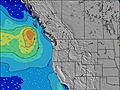 | 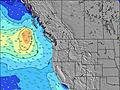 | 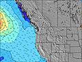 | 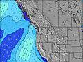 | 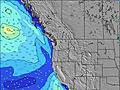 | 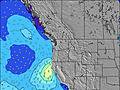 | 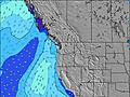 | 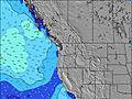 | |||||||||||||||
Onda Altezza (m) Direzione Periodo (s) | W 10 | W 9 | W 9 | W 9 | SW 18 | W 18 | W 19 | W 19 | W 19 | W 18 | W 18 | W 17 | W 17 | W 17 | W 17 | W 17 | W 16 | W 16 | W 16 | WNW 11 | WNW 10 | WNW 10 | WNW 10 | WNW 10 |
Grafico delle onde | ||||||||||||||||||||||||
188 | 173 | 165 | 162 | 152 | 162 | 116 | 116 | 173 | 161 | 150 | 206 | 197 | 270 | 287 | 200 | 260 | 254 | 251 | 313 | 318 | 307 | 307 | 288 | |
Vento (km/h) | ||||||||||||||||||||||||
Stato del vento onshore cross-onshore cross-shore cross-offshore offshore piatto | glassy | on | on | cross-on | cross-on | cross-on | glassy | glassy | glassy | cross | cross | cross | cross | cross-off | cross-off | cross-off | cross-off | cross | cross-on | on | glassy | glassy | cross-off | glassy |
Alta Marea | 2:33PM2.18m | 1:51AM2.71m | 3:15PM2.26m | 2:42AM2.56m | 3:56PM2.31m | 3:34AM2.34m | ||||||||||||||||||
Basso Marea | 7:57AM-0.80m | 7:58PM0.57m | 8:41AM-0.69m | 8:50PM0.49m | 9:24AM-0.51m | 9:43PM0.44m | ||||||||||||||||||
5:33 | — | — | — | — | — | — | 5:35 | — | — | — | — | — | — | — | 5:35 | — | — | — | — | — | — | — | 5:37 | |
— | — | — | — | 9:13 | — | — | — | — | — | — | — | 9:12 | — | — | — | — | — | — | — | 9:10 | — | — | 9:09 | |
mm | — | — | — | — | — | — | — | — | 1 | — | 1 | 2 | — | — | — | — | — | — | — | — | — | — | — | — |
Temp. °C | 12 | 15 | 15 | 15 | 14 | 13 | 13 | 13 | 14 | 14 | 14 | 14 | 14 | 13 | 14 | 13 | 14 | 15 | 16 | 15 | 15 | 13 | 13 | 13 |
Gelo °C | 12 | 14 | 13 | 13 | 12 | 12 | 13 | 13 | 14 | 12 | 12 | 13 | 13 | 11 | 12 | 11 | 12 | 13 | 14 | 14 | 15 | 13 | 12 | 13 |
Onda 1 Altezza (m) Direzione Periodo (s) | W 10 | W 9 | W 9 | W 9 | WNW 9 | WNW 8 | WNW 8 | WNW 8 | WNW 8 | WNW 8 | W 7 | W 7 | W 7 | WNW 8 | WNW 8 | WNW 8 | WNW 8 | WNW 8 | WNW 7 | WNW 11 | WNW 10 | WNW 10 | WNW 10 | WNW 10 |
188 | 173 | 165 | 162 | 123 | 122 | 116 | 116 | 104 | 105 | 112 | 131 | 134 | 151 | 178 | 151 | 131 | 99 | 76 | 313 | 318 | 307 | 307 | 288 | |
Onda 2 Altezza (m) Direzione Periodo (s) | SW 13 | WSW 18 | SW 18 | SW 18 | SW 18 | W 18 | W 19 | W 19 | W 19 | W 18 | W 18 | W 17 | W 17 | W 17 | W 17 | W 17 | W 16 | W 16 | WNW 11 | W 16 | W 16 | W 16 | W 16 | W 16 |
78 | 121 | 152 | 152 | 152 | 162 | 110 | 111 | 173 | 161 | 150 | 206 | 197 | 270 | 287 | 200 | 260 | 254 | 126 | 183 | 248 | 245 | 242 | 239 | |
Onda 3 Altezza (m) Direzione Periodo (s) | SW 18 | SW 12 | SW 12 | SW 12 | W 18 | SW 18 | SW 17 | SW 17 | SW 16 | SW 16 | SW 16 | SW 16 | SW 16 | SW 16 | SW 16 | SW 16 | WNW 12 | WNW 11 | W 16 | SW 19 | SW 19 | SW 19 | SW 19 | SW 19 |
80 | 39 | 38 | 38 | 103 | 108 | 77 | 72 | 69 | 67 | 66 | 90 | 90 | 90 | 124 | 124 | 46 | 102 | 251 | 179 | 130 | 181 | 130 | 94 | |
onde vento Altezza (m) Direzione Periodo (s) | — | — | — | — | — | — | — | — | — | — | — | — | SSE 2 | SSE 2 | — | SSE 3 | SSE 3 | S 3 | S 4 | — | — | — | — | — |
— | — | — | — | — | — | — | — | — | — | — | — | 1 | 1 | — | 3 | 2 | 4 | 4 | — | — | — | — | — | |
Il più vicino Offshore or Glassy | ||||||||||||||||||||||||
Distanza (km) | 0 | 53 | 1236 | 1234 | 65 | 65 | 0 | 0 | 0 | 49 | 49 | 49 | 47 | 0 | 0 | 0 | 0 | 53 | 116 | 254 | 0 | 0 | 0 | 0 |
Migliori previsioni per le condizioni d'onda in Washington State | ||||||||||||||||||||||||
Migliori previsioni per le condizioni d'onda in United States | ||||||||||||||||||||||||
Trova Onde Globale | ||||||||||||||||||||||||
- Map Icons:
 Break
Break Live Wave Height (m)
 Live Wind Speed (km/h)
 Surf Rating (10 Max)
 Ocean Swells (m)
- Wind Speed (km/h)
Widget Free Surf-Forecast.com per il tuo sito
La relazione di surf / widget meteo è disponibile qui sotto per incorporare su siti esterni a titolo gratuito e fornisce una sintesi delle nostre La Push previsione surf. Basta prendere il frammento di codice html da noi fornito e copiarlo nel proprio sito. È possibile scegliere la lingua preferita e unità metriche / imperiali per il feed delle previsioni surf per soddisfare le esigenze degli utenti del vostro sito .... Clicca qui per ottenere il codice.
 Nearest