
Previsioni:

Previsione a breve terminePioggia abbondante (Totale 37mm), più pesante durante venerdì notte. Very mild (Max 12°C giovedì pomeriggio, Min 6°C Sabato notte). Venti in aumento (calma giovedì notte, venti freschi da NNE per venerdì notte). | |||||||||||||||||||||
Gio 16 | Venerdì 17 | Sabato 18 | |||||||||||||||||||
11 AM | 2 PM | 5 PM | 8 PM | 11 PM | 2 AM | 5 AM | 8 AM | 11 AM | 2 PM | 5 PM | 8 PM | 11 PM | 2 AM | 5 AM | 8 AM | 11 AM | 2 PM | 5 PM | 8 PM | 11 PM | |
Mappa dell'altezza del moto ondoso |  |  | 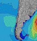 | 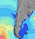 |  |  | 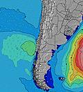 | 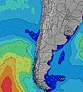 | |||||||||||||
Onda Altezza (m) Direzione Periodo (s) | N 10 | NNW 11 | NNW 11 | NNW 10 | NW 10 | NW 10 | NW 10 | NW 10 | NW 10 | NW 10 | NW 9 | NW 9 | NW 9 | NW 9 | N 9 | WSW 12 | N 10 | N 10 | N 9 | N 9 | WNW 12 |
Grafico delle onde | |||||||||||||||||||||
7326 | 5670 | 3477 | 2377 | 989 | 842 | 716 | 602 | 479 | 391 | 300 | 269 | 246 | 192 | 372 | 1180 | 414 | 356 | 241 | 188 | 412 | |
Vento (km/h) | |||||||||||||||||||||
Stato del vento onshore cross-onshore cross-shore cross-offshore offshore piatto | cross-on | cross-on | cross-on | cross | glassy | glassy | glassy | cross-off | glassy | cross-on | cross-off | cross-off | cross-off | cross-on | on | cross | cross | glassy | glassy | glassy | glassy |
Alta Marea | 12:09PM1.70m | 00:46AM1.06m | 12:54PM1.60m | 1:32AM1.08m | 1:39PM1.46m | ||||||||||||||||
Basso Marea | 6:52PM-0.05m | 6:20AM0.11m | 7:34PM0.00m | 7:11AM0.18m | 8:15PM0.08m | ||||||||||||||||
— | — | — | — | — | — | — | 8:03 | — | — | — | — | — | — | — | 8:02 | — | — | — | — | — | |
— | — | 5:54 | — | — | — | — | — | — | — | 5:55 | — | — | — | — | — | — | — | 5:57 | — | — | |
mm | 8 | 9 | 1 | — | — | — | — | — | — | — | 1 | 4 | 5 | 10 | 4 | 1 | 1 | 1 | — | — | — |
Temp. °C | 12 | 12 | 11 | 10 | 10 | 10 | 10 | 9 | 11 | 12 | 11 | 10 | 10 | 11 | 12 | 10 | 9 | 9 | 9 | 9 | 8 |
Gelo °C | 4 | 8 | 9 | 9 | 9 | 9 | 9 | 7 | 10 | 10 | 9 | 8 | 8 | 7 | 6 | 6 | 7 | 7 | 7 | 7 | 6 |
Onda 1 Altezza (m) Direzione Periodo (s) | SW 16 | SW 16 | NNW 11 | NNW 10 | NW 10 | NW 10 | NW 10 | NW 10 | NW 10 | NW 10 | NW 9 | NW 9 | NW 9 | NW 9 | SW 12 | N 9 | N 10 | N 10 | N 9 | N 9 | WNW 12 |
159 | 196 | 3477 | 2377 | 989 | 842 | 716 | 602 | 479 | 391 | 300 | 269 | 246 | 192 | 314 | 463 | 414 | 356 | 241 | 188 | 412 | |
Onda 2 Altezza (m) Direzione Periodo (s) | — | — | SW 15 | SW 14 | N 10 | N 10 | N 10 | N 9 | N 9 | N 9 | SW 13 | SW 13 | SW 13 | SW 12 | NW 9 | SW 12 | SW 12 | SW 7 | SW 11 | SW 11 | N 9 |
— | — | 266 | 248 | 569 | 494 | 371 | 251 | 241 | 235 | 424 | 363 | 352 | 324 | 163 | 23 | 195 | 119 | 344 | 263 | 148 | |
Onda 3 Altezza (m) Direzione Periodo (s) | — | — | — | WSW 15 | WSW 8 | WSW 8 | SW 8 | SW 13 | SW 13 | SW 13 | N 9 | N 9 | N 9 | N 9 | W 13 | — | NW 9 | SW 11 | WNW 10 | NW 10 | SW 11 |
— | — | — | 74 | 256 | 175 | 119 | 250 | 444 | 437 | 198 | 165 | 157 | 160 | 55 | — | 83 | 182 | 164 | 94 | 198 | |
onde vento Altezza (m) Direzione Periodo (s) | N 10 | NNW 11 | — | — | — | — | — | — | — | — | — | — | — | SE 3 | N 9 | WSW 12 | SW 7 | — | — | — | — |
7326 | 5670 | — | — | — | — | — | — | — | — | — | — | — | 2 | 372 | 1180 | 200 | — | — | — | — | |
Il più vicino Offshore or Glassy | |||||||||||||||||||||
Distanza (km) | 1299 | 1299 | 547 | 30 | 0 | 0 | 0 | 0 | 0 | 45 | 0 | 0 | 0 | 45 | 1046 | 536 | 30 | 0 | 0 | 0 | 0 |
Migliori previsioni per le condizioni d'onda in Concepcion | |||||||||||||||||||||
Migliori previsioni per le condizioni d'onda in Chile | |||||||||||||||||||||
Trova Onde Globale | |||||||||||||||||||||
- Map Icons:
 Break
Break Live Wave Height (m)
 Live Wind Speed (km/h)
 Surf Rating (10 Max)
 Ocean Swells (m)
- Wind Speed (km/h)
Widget Free Surf-Forecast.com per il tuo sito
La relazione di surf / widget meteo è disponibile qui sotto per incorporare su siti esterni a titolo gratuito e fornisce una sintesi delle nostre Las Peñas previsione surf. Basta prendere il frammento di codice html da noi fornito e copiarlo nel proprio sito. È possibile scegliere la lingua preferita e unità metriche / imperiali per il feed delle previsioni surf per soddisfare le esigenze degli utenti del vostro sito .... Clicca qui per ottenere il codice.
 Nearest