
Previsioni:

Previsione a breve terminePioggia moderata (Totale 19mm), più pesante mercoledì notte. Warm (Max 28°C Lunedì mattina, Min 27°C Lunedì pomeriggio). Principalmente venti freschi. | ||||||||||||||||||||||||
Lunedì 3 | Martedì 4 | Mercoledì 5 | ||||||||||||||||||||||
1 AM | 4 AM | 7 AM | 10 AM | 1 PM | 4 PM | 7 PM | 10 PM | 1 AM | 4 AM | 7 AM | 10 AM | 1 PM | 4 PM | 7 PM | 10 PM | 1 AM | 4 AM | 7 AM | 10 AM | 1 PM | 4 PM | 7 PM | 10 PM | |
Mappa dell'altezza del moto ondoso |  | 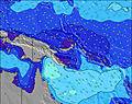 | 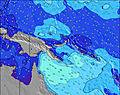 | 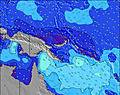 | 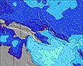 | 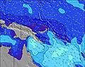 | 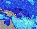 | 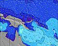 | 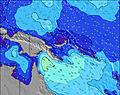 | |||||||||||||||
Onda Altezza (m) Direzione Periodo (s) | NNE 15 | NNE 14 | NNE 14 | NNE 13 | NNE 13 | NNE 13 | NNE 13 | NNE 13 | NNE 13 | NNE 14 | NNE 14 | NNE 13 | NNE 13 | NNE 13 | NNE 13 | N 13 | N 12 | N 13 | N 13 | N 13 | N 13 | N 12 | N 12 | N 12 |
Grafico delle onde | ||||||||||||||||||||||||
84 | 178 | 108 | 158 | 158 | 154 | 147 | 129 | 93 | 154 | 189 | 187 | 187 | 184 | 176 | 161 | 72 | 166 | 88 | 171 | 166 | 148 | 143 | 105 | |
Vento (km/h) | ||||||||||||||||||||||||
Stato del vento onshore cross-onshore cross-shore cross-offshore offshore piatto | cross-on | cross-on | cross-on | cross-on | cross-on | cross-on | cross-on | cross-on | cross-on | cross-on | cross-on | cross-on | cross-on | cross-on | cross-on | cross-on | cross-on | cross | cross-on | cross-on | cross-on | cross-on | cross-on | cross-on |
Alta Marea | 11:24PM0.90m | 3:46AM1.00m | 7:00AM1.02m | 7:32PM1.20m | 11:39PM0.90m | 3:57AM0.85m | 7:52AM0.89m | 5:13PM1.09m | 8:01PM1.19m | 00:02AM0.89m | 8:43AM0.75m | 5:16PM1.15m | 8:29PM1.19m | |||||||||||
Basso Marea | 10:28PM0.90m | 1:04AM0.88m | 5:16AM0.97m | 10:23AM0.68m | 11:00PM0.89m | 2:11AM0.81m | 5:47AM0.81m | 10:27AM0.71m | 5:27PM1.09m | 11:32PM0.89m | 6:23AM0.64m | 10:33AM0.68m | 6:31PM1.13m | |||||||||||
— | 6:01 | — | — | — | — | — | — | — | 6:01 | — | — | — | — | — | — | — | 6:01 | — | — | — | — | — | — | |
— | — | — | — | — | 6:02 | — | — | — | — | — | — | — | 6:02 | — | — | — | — | — | — | — | 6:02 | — | — | |
mm | — | 2 | 1 | — | — | — | — | — | — | — | 1 | — | — | 1 | 2 | 1 | 1 | — | 2 | 1 | 1 | 2 | 1 | 3 |
Temp. °C | 27 | 27 | 27 | 28 | 28 | 28 | 27 | 27 | 27 | 27 | 27 | 27 | 28 | 28 | 27 | 28 | 27 | 27 | 27 | 28 | 28 | 28 | 27 | 27 |
Gelo °C | 28 | 28 | 28 | 28 | 28 | 28 | 28 | 27 | 26 | 28 | 28 | 28 | 30 | 30 | 28 | 28 | 29 | 27 | 27 | 30 | 30 | 30 | 29 | 30 |
Onda 1 Altezza (m) Direzione Periodo (s) | NE 12 | NNE 14 | NNE 14 | NNE 13 | NNE 13 | NNE 13 | NNE 13 | NNE 13 | NNE 13 | NNE 14 | NNE 14 | NNE 13 | NNE 13 | NNE 13 | NNE 13 | N 13 | N 12 | N 13 | N 13 | N 13 | N 13 | N 12 | N 12 | N 12 |
71 | 178 | 108 | 158 | 158 | 154 | 147 | 129 | 93 | 154 | 189 | 187 | 187 | 184 | 176 | 161 | 72 | 166 | 88 | 171 | 166 | 148 | 143 | 105 | |
Onda 2 Altezza (m) Direzione Periodo (s) | ENE 15 | ENE 14 | NE 12 | ESE 5 | ESE 9 | ENE 13 | ENE 13 | ENE 13 | ENE 13 | ESE 10 | E 10 | E 8 | ESE 9 | E 9 | E 9 | E 9 | E 9 | ESE 9 | NNE 12 | ENE 11 | E 9 | ENE 11 | ESE 9 | ESE 9 |
71 | 70 | 35 | 8 | 29 | 60 | 60 | 60 | 60 | 52 | 47 | 30 | 47 | 42 | 42 | 43 | 42 | 28 | 46 | 50 | 39 | 48 | 26 | 26 | |
Onda 3 Altezza (m) Direzione Periodo (s) | NNE 15 | SW 6 | ESE 9 | ENE 14 | ENE 14 | ESE 10 | ESE 10 | ESE 10 | ESE 10 | SSW 6 | ENE 13 | ENE 13 | ENE 12 | ENE 12 | ENE 12 | ENE 13 | NNE 14 | ENE 13 | ENE 13 | SSW 6 | ENE 11 | E 4 | ENE 11 | ENE 11 |
84 | 9 | 27 | 66 | 36 | 19 | 19 | 19 | 31 | 17 | 67 | 65 | 60 | 60 | 51 | 62 | 62 | 64 | 64 | 7 | 48 | 6 | 49 | 51 | |
onde vento Altezza (m) Direzione Periodo (s) | SSE 3 | SSE 4 | S 6 | SSW 7 | SSW 7 | SSW 7 | S 7 | S 7 | S 7 | SSW 6 | S 6 | S 6 | SSW 6 | SSW 6 | — | — | SSW 6 | — | E 9 | E 9 | ESE 9 | — | — | — |
3 | 5 | 21 | 25 | 35 | 37 | 47 | 47 | 34 | 53 | 29 | 28 | 13 | 6 | — | — | 7 | — | 41 | 40 | 82 | — | — | — | |
Il più vicino Offshore or Glassy | ||||||||||||||||||||||||
Distanza (km) | 3 | 3 | 2 | 2 | 2 | 2 | 3 | 839 | 822 | 3 | 3 | 3 | 2 | 2 | 3 | 822 | 2 | 822 | 629 | 3 | 2 | 2 | 3 | 2 |
Migliori previsioni per le condizioni d'onda in New Ireland | ||||||||||||||||||||||||
Migliori previsioni per le condizioni d'onda in Papua New Guinea | ||||||||||||||||||||||||
Trova Onde Globale | ||||||||||||||||||||||||
- Map Icons:
 Break
Break Live Wave Height (m)
 Live Wind Speed (km/h)
 Surf Rating (10 Max)
 Ocean Swells (m)
- Wind Speed (km/h)
Widget Free Surf-Forecast.com per il tuo sito
La relazione di surf / widget meteo è disponibile qui sotto per incorporare su siti esterni a titolo gratuito e fornisce una sintesi delle nostre Long Long previsione surf. Basta prendere il frammento di codice html da noi fornito e copiarlo nel proprio sito. È possibile scegliere la lingua preferita e unità metriche / imperiali per il feed delle previsioni surf per soddisfare le esigenze degli utenti del vostro sito .... Clicca qui per ottenere il codice.
 Nearest